Trip Reports
Log in to add a reportDC
Delbert Carter
Sep 13, 2011
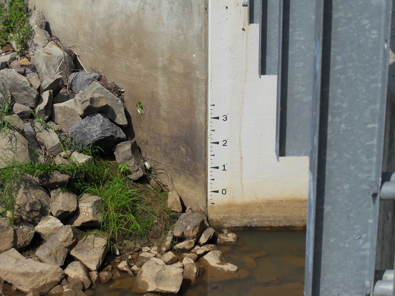
Here is a new gauge that 'somebody' put on the Saxon bridge. -2' is the lowest I'd recommend for the Fairdale to Arnett section and -5' is the lowest I'd recommend for the Dry Creek to Sundial (Pettry Bottom) section.
DC
Delbert Carter
Apr 9, 2006
Here is 'Rock wall #2' at 14' above 0' on the tree trunk gauge
DC
Delbert Carter
Feb 9, 2006
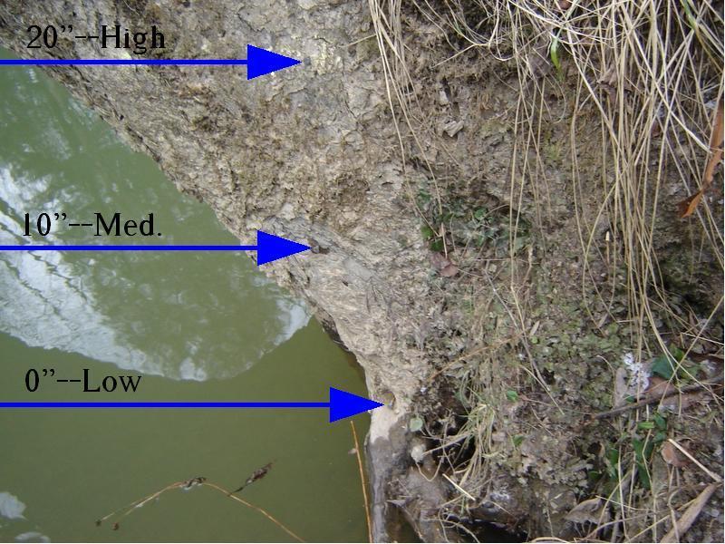
This is the tree just down stream of the Saxon bridge that I use as a gauge for the Marsh fork, (see other tree gauge photo). There are 3 nails, the bottom nail represents 0' (lowest recommended level), I paddled this section at -2' once, the rapids were still fun but it was pretty scrapy where the creek widens here and there. The middle nail (10' above 0'), is where it gets noticably faster and pushy. Between the middle nail and the top nail (20' above 0') it really picks up the pace! The highest I paddled this section was 30' above 0', I portaged 'Rock wall #2' on the right, but the rest of the run was good to go. It is kind of hard to see the nails in this picture, so I pointed them out.
DC
Delbert Carter
Feb 8, 2006
Looking down stream from the Saxon bridge you can see the over hanging tree that I use to gauge the level of the Marsh fork. Just past the tree there is a pull off spot on right side of the road. On the down stream side of the tree trunk there are 3 nails, the lowest nail represents 0', (lowest recommended level), I paddled this section at -2' once, the rapids were still fun but it was pretty scrapy at some of the wider sections. The middle nail (10' above 0') is when it starts getting noticably faster and pushy. Between the middle nail and the top nail it really picks up the pace. The highest I've paddled this section was 30' above 0', I portaged 'Rock wall #2' on the right, but the rest of the run was good to go. See other tree gauge photo.
DC
Delbert Carter
Jan 20, 2006
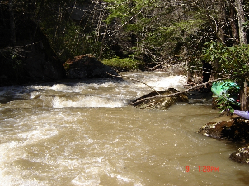
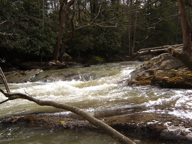
This is a low water picture of 3 of 5 ledges known as the Stairsteps. I have a tree trunk gauge that I go by. The lowest I've paddled the Fairdale to Arnett section of the Marsh fork was a scrapy -2', the highest was a fast big water feeling 30'. This picture was low water, 1'.
I live about one mile from a tree trunk gauge I use to determine the level. From 0' to 20' this photo shows a low level of 1'.
On a tree trunk gauge ranging from 0' to 20' this photo shows a low level of 1'.
From 0' to 20' on a tree trunk gauge I use, this photo shows 1'. I call it Jail house because a big tree fell across the end of the rapid and branchs that resemble jail bars used to hang down into the water and you had to make it through the 'bars'. Most of them has broken off now and the tree is about 7 to 8 feet above the water.
From 0' to 20' on the tree trunk gauge I use, this photo shows a low level of 1'.
The tree crossing the river used to have branches hanging down into the water that resembled jail bars, you had to make it through the 'bars' then punch a hole. The tree trunk gauge I go by, from 0' to 20', this was a low level of 1'.
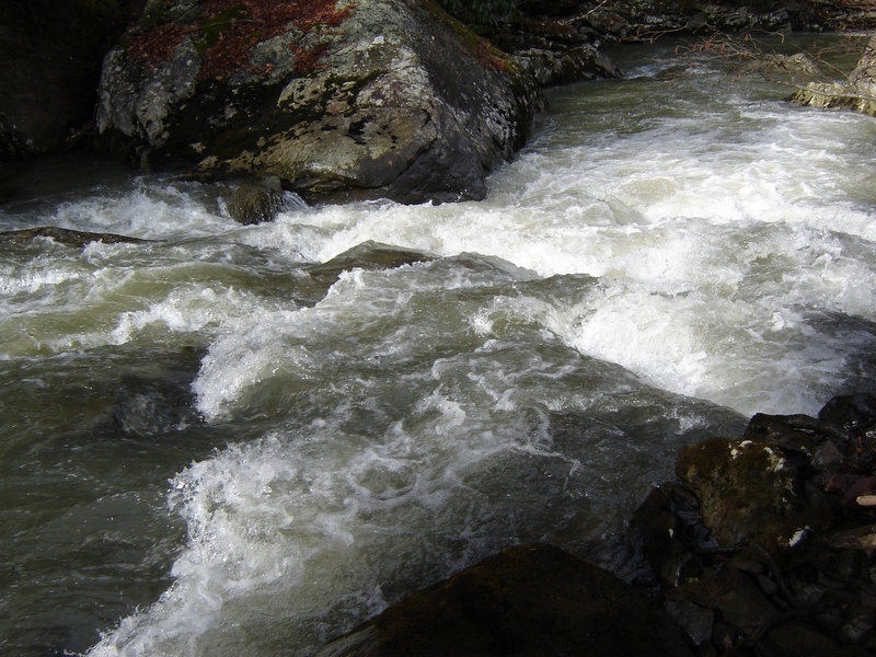
This rapid is pretty tame at lower levels, but at higher levels the water flows more into the undercut. I always get out on river right and look to make sure a strainer hasn't been lodged across the bottom (you can't tell from your boat). There was a strainer there for a while but it's been clear for a few years now. From 0' to 20' on a tree trunk gauge that I go by, this photo shows a low level of 1'.
I call this Rock wall #2 because just up stream there is a simular rapid that is a bit tamer. At higher levels the current slams into the 'rock wall' at the bottom right side of the rapid. I portaged it on river right one day, (there is a small clearing that makes it an easy portage), it was the highest I've ever run this section of the Marsh fork, the big rock on river left was sending a huge curler wave directly into the 'rock wall', I wasn't sure if I could punch through it. I have a tree trunk gauge that I go by that ranges from 0' to 20', this photo shows a low level of 1'.
DC
Delbert Carter
Jan 20, 2006
I call this Rock wall #2. It is between Fairdale and the Saxon bridge. On my tree trunk gauge ranging from 0' to 20', this photo shows a low level of about 1'. Any lower it starts getting scrapy in spots, I have paddled it once at -2', the rapids were still fun but it was pretty scrapy in some of the wider sections.
SW
Steve Weliver
Jan 1, 1900
A broken down rock weir provides a short boulder-bed rapid. This is located at Camp Comfort Co. Park north of Clarksville.
DC
Delbert Carter
Jan 1, 1900
From this perspective you can see what I call 'pillow rock' on river left, at higher levels pillow rock sends a curler wave straight into the 'rock wall' boulder. At around 15' and higher I portage on river right because the curler wave looks like you 'might' be able to punch through it, if you don't make it, it'll slam you into the 'rock wall'. I always go to the one boat eddy on river right regardless of the level, from there you can see if the rapid is clear and the line that you wan't to take, or you can make an easy portage. This photo shows a low level of 1' (using the tree trunk gauge).
