Big Sandy Creek (Cheat trib.)
3. Rockville to Jenkinsburg Bridge (Cheat River)(Lower Big Sandy)
| Difficulty | IV-V |
| Length | 5.1 mi |
| Avg Gradient | 79 fpm |
| Reach Info Last Updated | June 22, 2025 |
River Description
Run Description
The Big Sandy is becoming more popular every year as the jewel of the Cheat River watershed, the largest undammed watershed east of the Mississippi. The run includes two waterfalls--Wonder Falls and the more challenging Big Splat--along with several technical class IV rapids. Big Splat is an AW Standard Rated Rapid with a difficulty of 5.1 when the Rockville Gauge reads 6.1.
At higher water levels (> 6' at Rockville), it's often fun to run the Upper Big Sandy or the Little Sandy before the Lower. This gives a longer run including good play and scenery, and it gives those who don't want to tackle the Lower a good opportunity to enjoy the Sandy without fear. You'll find a nice surfing wave at the Rockville putin, and a great view of the beautiful Sovern Run Falls.
For a Go Pro helmet cam video of Wonder Falls, Zoom Flume, Little Splat, and Big Splat, go to http://www.youtube.com/watch?v=nRcwW2Bs-rU
Logistics
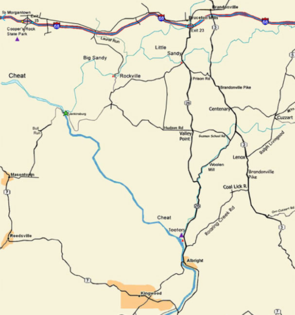
For those coming from the West, there is now a better road that goes South to Rockville from Morgantown Road. Turn under I-68 at Laurel Run and follow to the NEW put-in parking lot. See the Keel-haulers' map.
From the East or South, you can still head south from Bruceton Mills(I-68) or north from Albright on WV 26 to Valley Point (just about 6 miles from either direction). Look for the turn-off to Hudson Road (WV 15), take it west for 4.8
...River Features
Put In - Rockville WV Bridge
Put in just below the Rockville bridge.
Wonder Falls
After a mile of mostly Class-3 ledgy stuff, with some good play, the paddler comes to Wonder Falls. This 18-footer, which follows a mildly complex set of offset diagonal holes, is one of the more photogenic rapids around, and it's easier than most falls of its height. Warning: at higher water, 6.5' or so, it sneers viciously at the off-line paddler, with a hydraulic that will multiply recirculate the unfortunate swimmer. Those who want to run it a second, third, or seventh time carry back up on river left, a short hike through the omnipresent rhododendrons. One paddling friend found a can of beer there once, which made the foot attainment doubly worthwhile!
Lat/Longitude coords for this and subsequent rapids are verified by GPS, helpfully provided by Charlie Walbridge.
Undercut Rock
Wonder Falls is followed by rapids that are typical of the character of the Sandy: continuous Class-3 boogie water. About a half mile along comes Undercut Rock, which lives up to its name only for those who choose to run it on the right. That line requires a strong punch of the hole that surfs the paddler into the rock. However, it's an easy ledge-drop for those who run it to the left of the rock.
Zoom Flume
Undercut Rock is the lead-in to the most intense section of the Sandy, beginning with Zoom Flume. Though this rapid can be run on the left, as AW safety guru Charlie Walbridge does, most boaters choose to take on a complex series of holes and diagonal waves just above a cheese-grater slide. This is where people tend to break paddles just out of the shrinkwrap, or put a grapefruit-sized hole in the shoulder of the article of clothing formerly known as 'drysuit.' Those who flip in Zoom Flume tend to favor one shoulder or elbow when they go to work the following Monday. Don't ask me how I know. See another good Zoom Flume pic by clicking here.
Little Splat
A short pool is abruptly punctuated by Little Splat. Not as notorious as its big brother, Little Splat can still pack a punch for the unwary. It's a long, technical rapid with a bad pinning rock at the end. My line begins at the far, far left, avoiding a ledge-hole that's grabbier than it looks. I then head for an eddy in the middle left before working my way to the far left again. Whatever you do, be sure to end up left of the pinning rock at the bottom (just to the river right of the paddler in the picture).
Big Splat
One short pool beyond Little Splat is the Biggie. There's no shame in walking Big Splat, a 15-footer in which all of the flow wants you to land on a bad piton rock. The line at the main drop is tough to read from water level. As if that weren't enough, the approach is gnarly, with undercuts and a bad keeper hole. This reporter once found himself upside-down through the horseshoe hole in the approach and barely rolled up in time for the main drop, an experience I never wish to repeat! Splat certainly lives up to its 5.1 AW rating. The portage is on river right, where a rope is attached to help you get down the ledgy drop.
Some first-timers walk around the gnarly approach to Splat and simply run the final drop.
Whether you walk or run Splat, it's a good idea to turn around and look back upstream. The view of the rocks, trees, and the travertine green water is something to treasure. It's part of why so many of us have fallen in love with the Big Sandy.
First Island
After Big Splat is some more of the Class-3 boogie water that makes the Sandy such a joy. The paddler has to keep his eyes open, as there are pinning spots to avoid (especially at low water) and some play holes to enjoy, but for the most part, it's a fun slalom adventure. About a mile downstream, soon after a good play hole, comes First Island. This is a pair of narrow slots separated by a narrow, deceptively short and fast 'pool.' The second slot requires a solid right boof against the flow that tries to land the paddler into a very unpleasant rock.
Coordinates from Jeff Macklin (verified by GPS). The coordinates of the end of this rapid are 39.60871, -79.73970.
Bridge Pier Rapid
Soon after First Island, when you see a rectangular concrete wall on River Left, you've come to this rapid, which has a big-ol' ledge-hole at higher levels.
Thanks to Jeff Macklin for the GPS coordinates for this rapid!
Second Island
Another mile below First Island is...Second Island. Not normally counted among the Big Sandy 'Biggies,' this one is a fun, straightforward Class-3+ boulder hop--unless you go left! If you go left, it's a blind, screaming drop with only a couple of feet of leeway. Call it a Class 5; this is a good rapid for elbow pads, as even a good line can give the paddler an unwelcome shot.
Just a few short yards below Second Island is the takeout, the confluence with the Cheat Canyon, and the beginning of the scariest experience of the day: the shuttle out!
Lat/longitude coordinates, verified by GPS, are courtesy of Jeff Macklin. Coords of the endo this rapid: 39.59684, -79.74444.
Take Out - Jenkinsburg Bridge
Takeout is at the Jenkinsburg Bridge just upstream on the Cheat River.
Trip Reports
Log in to add a reportNo trip reports yet.