Birch
1. Boggs to Cora Brown Bridge

| Difficulty | II+(IV) |
| Length | 12 mi |
| Avg Gradient | 53 fpm |
| Gauge | Birch River at Herold, Wv |
| Flow Rate as of 1 hour | 1.95 ftbelow recommended |
| Reach Info Last Updated | December 28, 2024 |
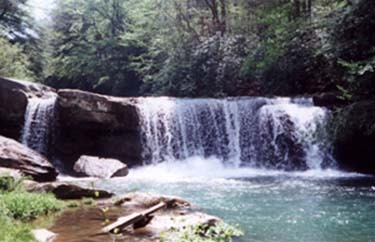
The biggest obstacle on this stretch of Birch is the Boggs Falls. It is an approximate 16 foot drop. This stretch of river is easily accessible as it is right beside the highway between Birch River and Boggs. An interesting feature found on the falls is a sluice that was cut into the solid rock to power a gristmill as shown in the extreme left of the picture.. Although the mill ceased to exist at least 50 years ago, the rock channel is there for eternity.
Oct 13, 2008
Robert Farmer---The waterfall is located 7.4 miles east of Route 19 (town of Birch River). There is no place to park or access the falls. I walked up the streambed from downstream; it is a very beautiful streambed, often with large ledges on the shores. The falls has a submerged ledge in the landing zone, approximately 2.5 - 3 feet below the surface at low water, all of the way across, except for a notch on the far river left, where the double lip is. If you want to do it, scout, stay left, and land shallow-to-flat. It looks as though it would be a nice trip, although the difficulty of the falls is greater than that of the rest of the creek.
Jan 1, 1900
This is the Boggs Falls, which is about a 16 foot drop. It used to be the site of a mill that had the water flume, that you can still see, hand cut out of the stone on the left side of the picture.