Cheat, Shavers Fork

3. McGee Run to Bemis

Reach banner
DifficultyIII-V
Length15 mi
Avg Gradientn/a
GaugeShavers Fork at Bemis, Wv
Flow Rate as of 22 minutes
3.49 ftlow runnable
Reach Info Last UpdatedMarch 12, 2026

River Description

Shavers at Bemis USGS Gauge

Upper Shaver's Fork is a classic remote WVA run requiring a full day of shuttling and paddling to access and enjoy. The first few miles are easy Class II-III. High Falls of the Cheat, a 15-20 ft riverwide ledge falls, marks the beginning of a Class IV section that is followed by several more miles of Class III-IV.

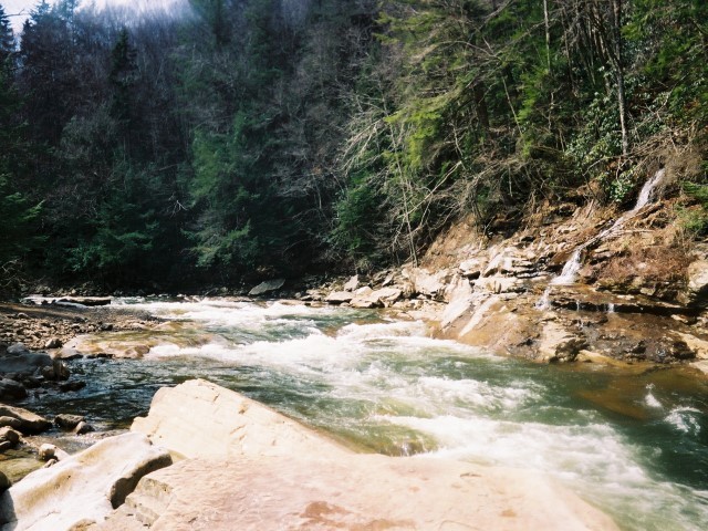
The run begins at McGee Run, which is located near railroad marker 61. At railroad marker 53, the river constricts and gorges up, marking the beginning of a mile of class 3 rapids above High Falls. The first of these rapids comes on a sharp right-hand bend and consists of 3 different series of 3 foot ledges. Through this section the river continually drops over a number of moderate-sized bedrock slides composed of varying types of rock.

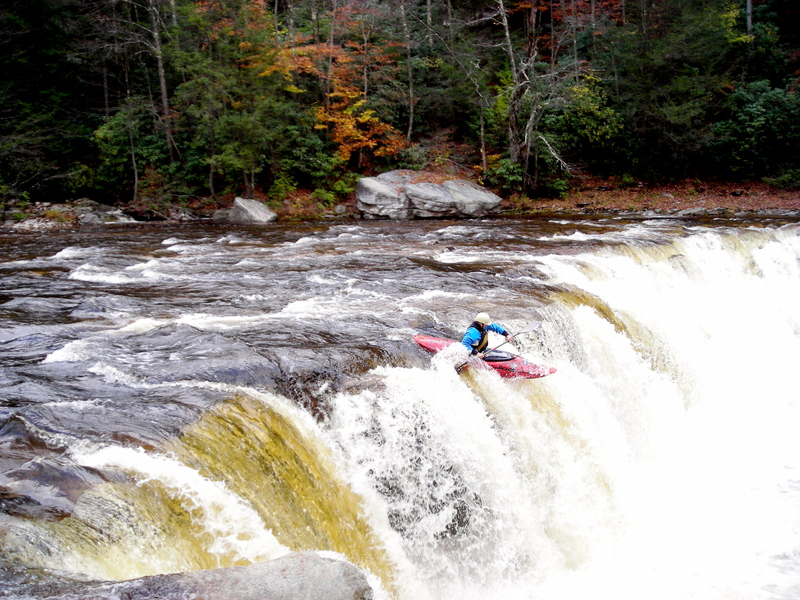
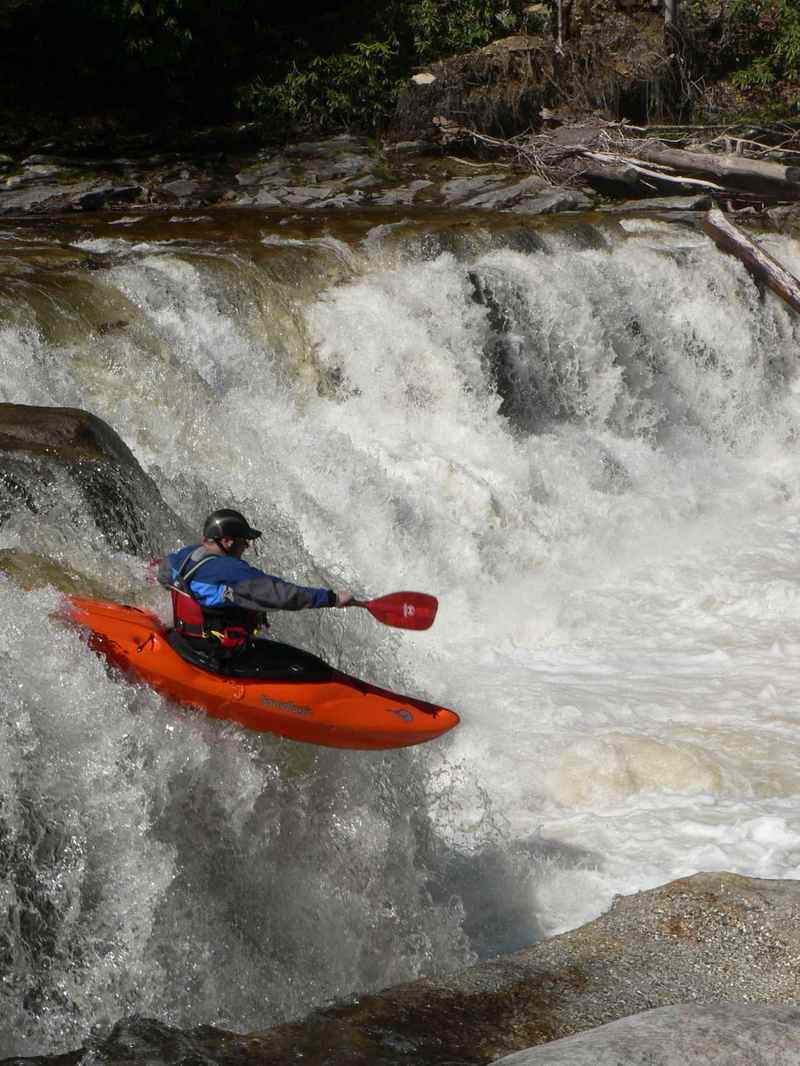
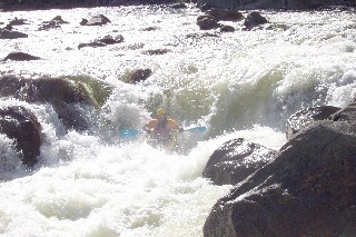
When you see a distinct horizon line, a wooden observation deck, and a primitive campsite, get out on river right to scout or portage High Falls. The cleanest line over the falls is right of center, just to the left of a rock promontory that can be jumped off of in low water. There is also a potential line on river right; however, this side of the falls is backed up by one of the biggest boils I have ever seen- it most definitely did not look friendly if you screwed up.

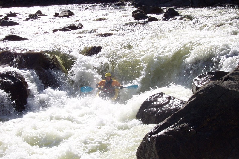
Below the falls, the river drops through several tough class 4 rapids. The first of these is a series of broken, boulder-strewn ledges with a tricky, technical line down the right or a narrow sneak down river left. The second drop below the falls consists of a long series of boulder drops which funneled the river towards an ugly pillowed boulder near river left. Below the boulder, which should be avoided at all costs, the rapid squeezes to the right over a drop which is partially blocked by a nasty strainer. Anyone with doubts about their ability to negotiate the technical approach to and the narrow gap through the strainer should

...

River Features

Put-In - McGee Run

Distance: 0 mi
Access Point

FROM BEMIS TO MCGEE RUN: Continue following CR 22 through Bemis and up the mountain- the road quickly turns to dirt/gravel, becoming very rough and muddy (4x4 might help but is not necessary). Resist the urge to take any of the many roads which branch off CR 22 as you climb up and over the mountain, particularly a lefthand private road which leads to nowhere (just continue following the main road to the right up the mountain and you should be fine). Eventually, CR 22 ends at a 3 way T intersection with an unmarked dirt road, which is CR 30 (Left Fork Files Creek Road). Take a left onto this road; you will know you are on the right one if you immediately pass a red farm gate on your right. This road soon becomes paved again, passing a couple side roads and several homes. Eventually it ends at a 3 way intersection with a stop sign. Turn left here onto CR 37/8 (Files Creek Road)- landmarks on this road include a gas refinery station on the immediate left after making the turn, an Izaak Walton League building on the left a little farther up, and the Tygart Valley Muzzleloaders shooting range on the left where the road turns into gravel. Continue following this road (resist the urge to take a right and cross a small bridge over a stream, continue left instead) until you come to Forest Service Route 92, which branches off to the left and is marked by a brown sign on a post which says '92'. Follow FR 92 for several miles, keeping your eyes open for FR 210 (McGee Run Road), which will branch off FR 92 to the left and is marked with a large brown sign marked '210'. Take this road to the putin at the Shavers Fork catch and release area (which has 3 primitive campsites). This part of the shuttle (Bemis to McGee Run) takes about an hour.

Take Out - Bemis

Distance: 15.19 mi
Access Point

To Bemis Take-out: From Route 33/55 heading west towards Elkins, turn left at Alpena (at the Alpine Motel) onto CR 27, following it to Glady. At Glady, bear right onto CR 22, which heads over the hill and down to Bemis. At Bemis, park along the right side of the road directly across the bridge over the Shaver's Fork (ask permission at the house on the right, the owner was very friendly and didn't mind us parking there at all- let's keep it that way).


AS
Andy Stuart

Apr 1, 2018


Finally got to run the Shavers Fork 3/31/18, McGee Run to US 33 (the trailer park where 33 turns from the river). When we put on, Cheat Bridge was at 562 cfs/6.9'. When we took off, Bowden was at 1500/6.5. Most agreed that any much lower would have started exposing many FU rocks.

By a Caltopo trace, McGee Run to Bemis is actully 15.4 miles and Bemis to 33 is 8.9.

MB
Mike Beswick

Jul 3, 2011


mike dropping high falls

MB
Mike Beswick

Jul 3, 2011


tyler flying over high falls

CP
CHRIS PREPERATO

Oct 18, 2010


Ran it 10/01/2010. Opting to try for a shorter put-in option, we hiked the High Falls trail to the river. We all agreed that, even though it cuts the shuttle to about 10-15mins each way, the 3 mile hike over the ridge is probably not worth it. The altitude gain isn't too bad, but it switchbacks quite a bit and took us over 2 hours of hiking

As for the river, the level was around 500cfs at Cheat Bridge, and 1400ish at Bowden. It had receded from levels of 4000 and 9000 respectively the previous day. High Falls had a few runnable lines, and the rapids between that and Railroad were fairly continuous Class 3+-4. Railroad itself would be best called a Class IV rapid, with a fairly obvious line down the right of center with a decent margin for error. With more water, I could see the hole being an issue

Mule Hole on the other hand looked more like a Class IV-V rapid...the right side ledge halfway down has a very strong backwash and low head dam qualities (and seems to feed an undercut shelf). The left line was shallow and had some decent sized holes as well.

?

Aug 12, 2010


Paddled Shavers Fork 8/5/2010, McGee Run to Bowden. The level was 450cfs at Cheat Bridge and 1300cfs at Bowden. This was a great level, no scraping and not pushy. I think we counted less than 5 (small)pools we had to paddle across. 20+miles of great waves and play with a few challenging rapids to keep your attention. No wood issues currently. Fantastic run.

SM
Shawn McClung

Apr 23, 2006


What a fun drop

NO
Nori Onishi

Apr 19, 2006


You want to lean forward on the fall so you do not land flat. If you mess it up just run it again and again
For the full-sized version of this photo, click here.

RS
Robert S. Farmer

Jan 28, 2006


I couldn't read through the enormous amount of info above, but it's worth noting that the Bemis gauge is not readable on-site (i.e. telemetric only), so don't look for it. Also, Carlos Kinder, 636-8113, has always done my shuttle for me. He lives in the house next to the railroad tracks.
Also, the drop called Mule Hole has an enormous, ugly, sickle-shaped undercut horizontal shelf on the right, exactly where you need to run. It's terrifying, and may be covered at higher levels. Be aware. I always end up ferrying hard left above it--kind of spooky. Uncertain boaters should portage.

JM
Jonathan Mayhew

Apr 18, 2004


Got another opportunity on 4/17/2004 to run the Shaver's Fork- the level when we put on at 9:00 AM was 3.6 ft Bemis, 6.0 ft Cheat Bridge. We found that this run was much scrapier this time around, despite the fact that the water was only an inch or so lower; keep this in mind when planning trips up here- small changes in water level overnight can be a big difference. Several of the smaller rapids at the top and a few of the larger rapids below High Falls were very tough to negotiate, causing us to run aground or become pinnned a few times. High Falls itself was too low for the Shredders this time, although a kayak could have easily ran it. One thing we have noticed about the drop on both trips is that the river right side of the falls is very dangerous- a massive boil (the boil constantly surges 3-4 feet above the pool level) blocks the outflow of the hole at the base of the falls. Additionally, due to the low water we noticed that there is a recess behind the waterfall curtain on this side of the falls that would not be a good place to end up. After running this section again, I realized that there were a few difficult and possibly dangerous rapids I simply didn't remember from the first trip. Most of these are straightforward but strong class 4 rapids similar to the bigger rapids on the Kitzmiller section of the North Branch Potomac. One rapid, though, deserves a mention, and comes about 2 miles below High Falls. The river bends slightly to the left and several large, rounded boulders split the flow into slots on river right. These slots carry the majority of the river's flow, as opposed to a wide, shallow, rocky sneak on river left. Unfortunately, these slots are completely blind from the top, and all of these boulders are severely undercut. The line starts from river right and forces the paddler to work hard towards river left through a narrow slot, avoiding a center channel which had 3 trees pinned in it today. This drop is pretty sketchy due to the undercuts and trees- if you are unsure about the safety of the passage it is best to try and bang down the sneak on river left. In general, we noticed alot more undercuts this run down; most of the major rapids have at least one undercut boulder or shelf of rock which would be fatal to a swimmer- one guy dropped his paddle on accident only to watch it disappear underneath a rock shelf just downstream (it never came out). As far as water level is concerned, kayakers should be fine down to the minimums in the guidebooks; rafters, however, would be wise to stay off the water unless it is at least 3.7 at Bemis- higher is probably better still though.

JM
Jonathan Mayhew

Apr 17, 2004


An upstream view of the first significant rapid on the Shavers Fork.
This picture shows an upstream view of the bottom of the first class 4 rapid below High Falls. The big ledge in the picture is best run on river right; however, the line is complicated upstream by several ledges and boulder drops which push left.
This is a downstream view into what is probably the hardest rapid that is not regularly portaged. The best route is to work towards river left, cutting in behind the large undercut halfway down the rapid- missing this move pushes the boater into a junky boulder pile or a nasty pinning rock. The strainer that was at the bottom of this rapid was flushed out by the high water last week.
This drop is located a couple bends above the railroad bridges and consists of a steep approach over a 5 foot ledge. Fun drop.
This succession of class 3 ledges (and the beautiful scenery around them) is characteristic of most of this run.