Cheat, Shavers Fork
3. McGee Run to Bemis
October 18, 2010
| Reporter | CHRIS PREPERATO |
Ran it 10/01/2010. Opting to try for a shorter put-in option, we hiked the High Falls trail to the river. We all agreed that, even though it cuts the shuttle to about 10-15mins each way, the 3 mile hike over the ridge is probably not worth it. The altitude gain isn't too bad, but it switchbacks quite a bit and took us over 2 hours of hiking
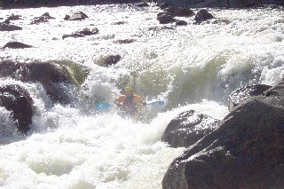
As for the river, the level was around 500cfs at Cheat Bridge, and 1400ish at Bowden. It had receded from levels of 4000 and 9000 respectively the previous day. High Falls had a few runnable lines, and the rapids between that and Railroad were fairly continuous Class 3+-4. Railroad itself would be best called a Class IV rapid, with a fairly obvious line down the right of center with a decent margin for error. With more water, I could see the hole being an issue
Mule Hole on the other hand looked more like a Class IV-V rapid...the right side ledge halfway down has a very strong backwash and low head dam qualities (and seems to feed an undercut shelf). The left line was shallow and had some decent sized holes as well.