| Difficulty | III-V |
| Length | 5.2 mi |
| Avg Gradient | 75 fpm |
| Gauge | Little Kanawha River Nr Wildcat, Wv |
| Flow Rate as of 55 minutes | 4.40 ftbelow recommended |
| Reach Info Last Updated | October 21, 2003 |
River Description
This reach does not have a description. If you know about this reach, please tell us about it!
River Features
Put In
Access PointDistance: 0 mi
Take Out
Access PointDistance: 5.4 mi
Trip Reports
Log in to add a reportCA
Charles and Nancy Brabec
Feb 27, 2007
Posted for Nori Onishi...
It requires a lot a rain to run. The online gauge at Wildcat reads the combination of Little Kanawha, Glady creek and right fork of the little Kanawha so you need a lot of water. I did it at 1200 cfs online gauge and It seem like there was 300 cfs in little Kanawha which felt like good level (upper yough at 2.0)
Take out. Make sure you have a gazetteer you are in the backcountry. Get off I 79 at Roanoke exit. Take 19 south until Ireland, WV. Take a left at CR 50 Wildcat rd. Turn left at CR 54 or Ingo bablin Rd just before you see the river. Drive up to Ingo there is a church there. You can park at Ingo if you only have a car but you can drive further up stream if you have a high clearance car. We parked along the road on someone summer camp about 2 miles up stream of Ingo. Not the first field which there is a rock fence but the second field with trailers.
Put in. From take out you drive back to Ingo. First road to the right Cr 46.1 will take you up Heaston ridge rd but 4x4 required or drive back to Ingo and take Cr 46 Cherry fork rd to Heaston ridge Rd. Drive the main rd on cherry fork rd until end and turn right. That will be Heaston ridge rd and just follow the paved road until Arlington. Make sure you scout the fall behind the Mill. At shop sign cross the two lanes and park at the church. That is the put in.
First Rapid is the Mill rapid. Run where the water is. Then it is boogey water for 2 miles. You can boat scout all these.
Cable rapid. After the 2nd or 3rd island the first class 4. It is a boulder garden. Start the run on the right side and to the center. At the end there is a cable hanging over the river but not an issue just duck under it.
Next rapid 1st mini gorge. Obvious horizon line. Scout on the left side. There are 3 slots on this rapid. We ran the right line and left line.
2nd rapid mini gorge. Aka Trash bin. Obvious horizon line but there is an island in the middle. You can sneak the left side or run the meat. 8 foot drop into some swallow landing. We paddle up the middle rock and boofed. Sweet. Down stream the drop there is wood but easy to get around.
The river gets easy after this until the take out.
Next time I will get pictures.
2-26-2007
Nori Onishi
RS
Robert S. Farmer
Jun 5, 2006
Caught it at 6.33, January, 2007. This level seems low. If you find the supercool 200-or-so-foot slide at the top even slightly intimidating, it gets much harder, so be warned. I shore-scouted seven times, sometimes only 100-200 feet apart. The first bad rapid appeared as I approached the bottom end of an island, on the right side. I almost wandered too far, which would have been ugly, you bet. I scouted left. At the bottom of this rapid is a two-log footbridge that someone has installed in a most-inconvenient place for kayaking (with a rotted old rope above--perhaps the 'cable' mentioned in the next posting).
Immediately downstream is the worst rapid. I scouted from midstream, and ended up doing a \'wheelchair\' move through a 20-or-so-inch-wide slot in the center. The right slot has a huge boulder in the middle; the left slots are sieves or blocked by logs. They might be runnable or more runnable with more water, but are certainly potentially fatal at low levels.
Soon is another large horizon line (12 feet high) on the right with the black cliff behind it. Notice how the water disappears underneath the horizon line. Sneak easily to the left of the island.
This creek is one of the rockiest creeks that I can remember! It is non-stop action, with lots of maneuvering for boat-scouting, and is quite difficult to find your way down safely without a guide. Taking out well-upstream of Ingo will eliminate some logs in the \'flat section\' that might need portaging at some levels. Quite a run!! I notice that the difficulty is listed as Class 3-5. There is nothing Class 3 about this run! Do not try it without at least a few Class 5\'s behind you. For comparison, this is probably harder and much tighter than Fikes Creek, certainly much harder than the Upper Yough at low release levels. Note that while I ran this at a low level, the posting after this one was done near the maximum recommended level, so beware of the differences!
The shuttle described above seems unnecessarily convoluted. Here's how I did it: From Buckhannon drive south on 20 to Arlington. Visually check the river level. Leave your boats at the church near the shore. Drive down river right on the road. Take one left turn near the top of the hill (I think), and then take the first left. (Just stay left--it's easy!) This leads to the river. Nothing complicated about it. I drove it in my old sedan without scraping. Halfway down the road, Leonard, who lives in the isolated cabin there, helped me run shuttle.
CW
Charles Walbridge
Apr 16, 2006
Ran the river today (4-16-06) at about 5.5. A nice low level EXCEPT that the big rapid in the mini gorge sieves out and becomes unrunnable. It was a nasty portage on the left. At the island drop next, be sure to run left rather than right into the black cliff. Either that or scout carefully. The final frop is 1--12' high and several passages drop into undercut rocks! Pretty creek!
JP
John Petretich
Mar 29, 2005
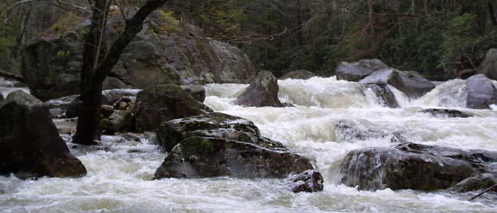
This rapid is characteristic of what you'll see for most of the day. Busy boulder rapids and a constricted river bed all enclosed in a scenic remote forest.
Mountain scenery and busy little rapids await around every corner in the early part of the run.
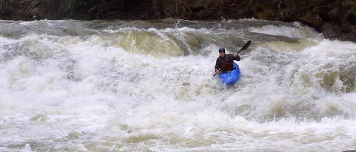
This is the entrance boof to the second rapid in the mini gorge. You'll have about 3-4 seconds of recovery time before having to maneuver out of the way of a bad strainer.
The only way through is to the right. The strainer blocks the entire left channel shown here. Yuck!
JP
John Petretich
Jan 1, 1900
This rapid is distinguishible from the large boulder on river right. The combination of ill placed logs and a nasty sieve were enough to persuade this lazy kayaker to walk down the bank. This rapid is the first of a short succession of difficult drops fondly known as 'Mini Gorge'.