Peters Creek
County 22 bridge to mouth
| Difficulty | II-III(IV) |
| Length | 3.2 mi |
| Avg Gradient | n/a |
| Gauge | Peters Creek Near Lockwood, Wv |
| Flow Rate as of 57 minutes | 37 cfsbelow recommended |
| Reach Info Last Updated | October 23, 2013 |
Lat/longitude coords are approximate, from TopoZone.
Oct 21, 2013
Ran this creek twice in September 2013 at 1000cfs and then at 200cfs. I would rate this creek class III+ at low water and IV(IV+) at higher flows which takes on a big water feel. I disagree with the below post about any of the rapids being class V on this run. The two rapids after the falls are definitely the crux of this run but are boat-scoutable. As noted below, the first rapid after the falls has a large undercut boulder on the left which is easy to avoid if you are on line and moving but one of our crew came really close to going under it. Also in the final rapid, there is a tree in the left line at 200cfs its chest high, at 1000cfs its probably in the landing zone. You have to force your way right at low flows to avoid it. Also the rapid above the falls has a undercut bolder on the river left, this one might be worth scouting on river left at higher flows, the line isn't difficult but you want to be on it.
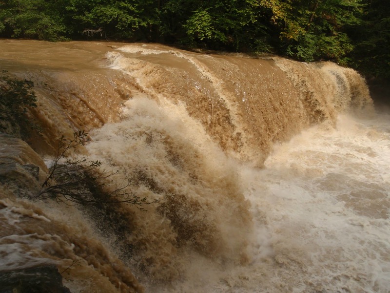
The falls did not look good at either of these levels, I think at medium flows would be fine though. We scouted and portaged on river right. Easiest put-in we found was a mile up panther creek rd at the bridge.
Sep 20, 2013
25ft waterfall on Peters creek at 1000cfs. Probably a too high the boil line was pretty large
Sep 20, 2013
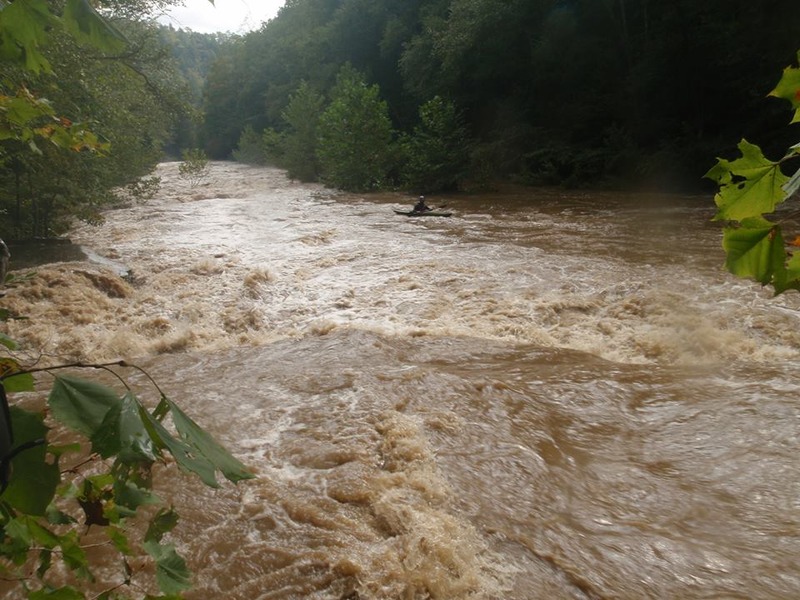
One of the first main rapids on Peters
Sep 20, 2013
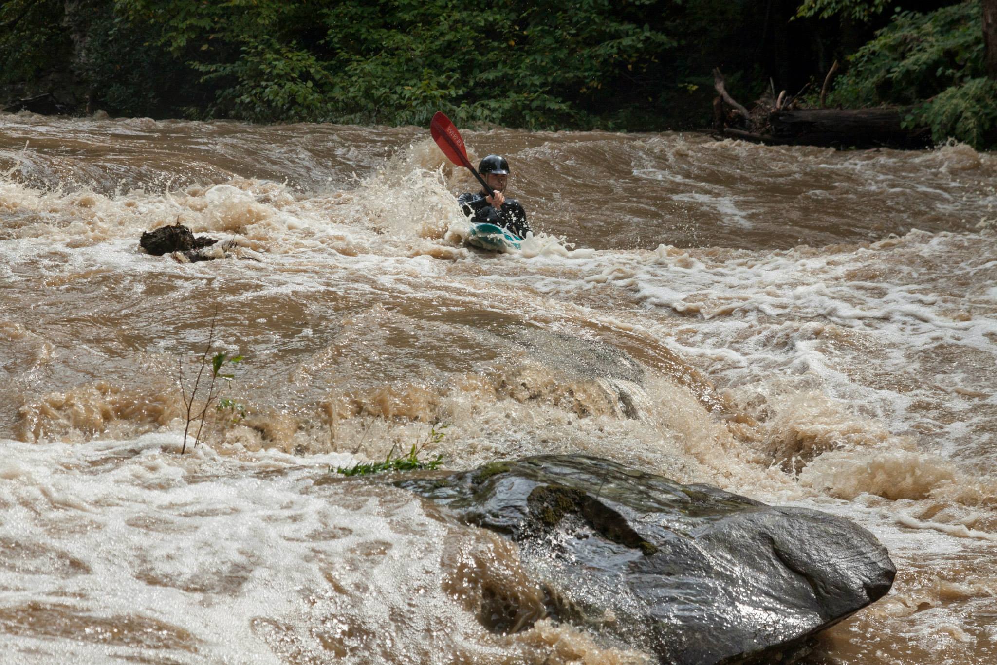
Last rapid above the falls. The left side is very undercut and hole is potentially sticky.
Sep 20, 2013
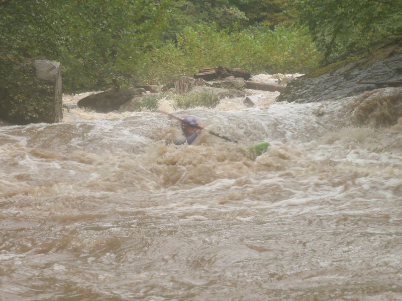
Final drop of peters. Note the there is a tree in the left line at 200cfs its chest high, at 1000cfs its probably in the landing zone. You have to force your way right at low flows to avoid it.
Aug 1, 2009
I ran this creek on 7-30-09 putting in at the Drennen Post Office (129 & 39 intersection) and running it all the way to the mouth on the Gauley. The upper half of is best suited as a canoe stream, virtually all swift water or Class I. The scenery is pleasant enough, more secluded than you might think, but not really outstanding. The faint of heart should definitely take out at the last car bridge crossing about a mile below where the creek leaves Route 39 for safety reasons.
The bottom half below the last car bridge is for expert kayakers only. The 'Big Three' rapids compose the formidible part of the run about midway into this section. The 20 foot falls is a Class VI drop, followed by two very technical Class V rapids (which I'll call 'Right Dogleg' and 'Rock Jumble'). The reason this section of the creek is not run very often is because portaging is VERY strenuous. The incline of the left bank (where the railroad tracks are) is so steep that it requires a long rope (both for pulling my boat up and lowering it down) for practical success.
20 Foot Falls is a straight drop just right of center but I'd recommend the pool be scouted at low water first in advance to see where any hazardous rocks may lie. Right Dogleg requires initially manuvering far right to avoid the undercut rock on the left, but the second half drop is cleaner on far left. Rock Jumble features a 'U' shaped ledge entrance with the majority of the water splitting into left and right channels. The bottom half of the rapid has a short pool followed by left and right slots with a 5 foot drop. I took the right channel at the top half, then took the left slot for the bottom drop.
The remainder of the run is not difficult, the only dilemma being whether to take out at the mouth of Peters Creek or continue on the lower 3rd of the Gauley. The only takeout option is to walk all the way back to the last bridge via the train tracks (not practical) so I decided to continue on to the Swiss takeout. This section features another 'Big Three' rapids on the larger Gauley....Mash, Heaven Help You, and Pure Screaming Hell for good measure. The shuttle distance from the town of Swiss (not the 1st takeout) to the last car bridge on Peters Creek is probably about 8 miles.
Jan 24, 2009
The 38 acres that the put in spot on peters creek resides on was recently purchased by my wife and I...this is pnow our home site and we will soon have rental cabins, and a new put in just upstream sfor those of you ythat are interested in covernight or weekly stays hon the property...The oproperty has been posted, so for those of you that would like access please email us in advance for permission at THRTKENNEL@AOL.COM Thanks Kevin & Terri Kershner
Dec 19, 2008
Peter's Creek is fun and does have a clean 20fter. If you look at the map you will see the train tracks go through a mountain. If you put in and paddle the 'loop' then once you get the the next train bridge the 20fter is about 1/4 mile away. You can walk the shuttle for the loop throught on the tracks. The other rapids are shallow ledges with nice play. Go intro creek for those in training. 250 cfs is good for the falls but the rest is good at 150cfs. Here is a link to some video and pictures. http://www.marshall.edu/muwc/peters.htm Heath Damron
Nov 17, 2008
Peter's Creek is not the put-in for the Lower Gauley. Peter's Creek confluences with the Lower Gauley near the railroad bridge upstream of Upper Mash. There's a clean 20 foot waterfall on this creek. This creek runs beside Peter's Creek Road just of route 39, which is on the way to the Lower Gauley put-in.
Apr 24, 2006
It is the really steep creek that peters creek road follows. It is the putin for the Lower Gauley.