Potomac, S. Branch

4. US 220 Bridge North of Upper Tract to Big Bend Campground(Upper Smokehole Canyon)

Reach banner
DifficultyI-III+
Length10 mi
Avg Gradient25 fpm
GaugeSouth Branch Potomac River at Franklin, Wv
Flow Rate as of 28 minutes
1.68 ftbelow recommended
Reach Info Last UpdatedApril 21, 2026

River Description

The easiest put-in is a 200 yards below the US 220 Bridge on river left at a river ford.

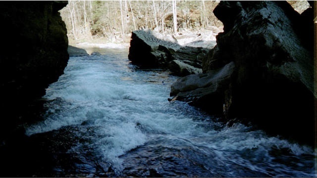
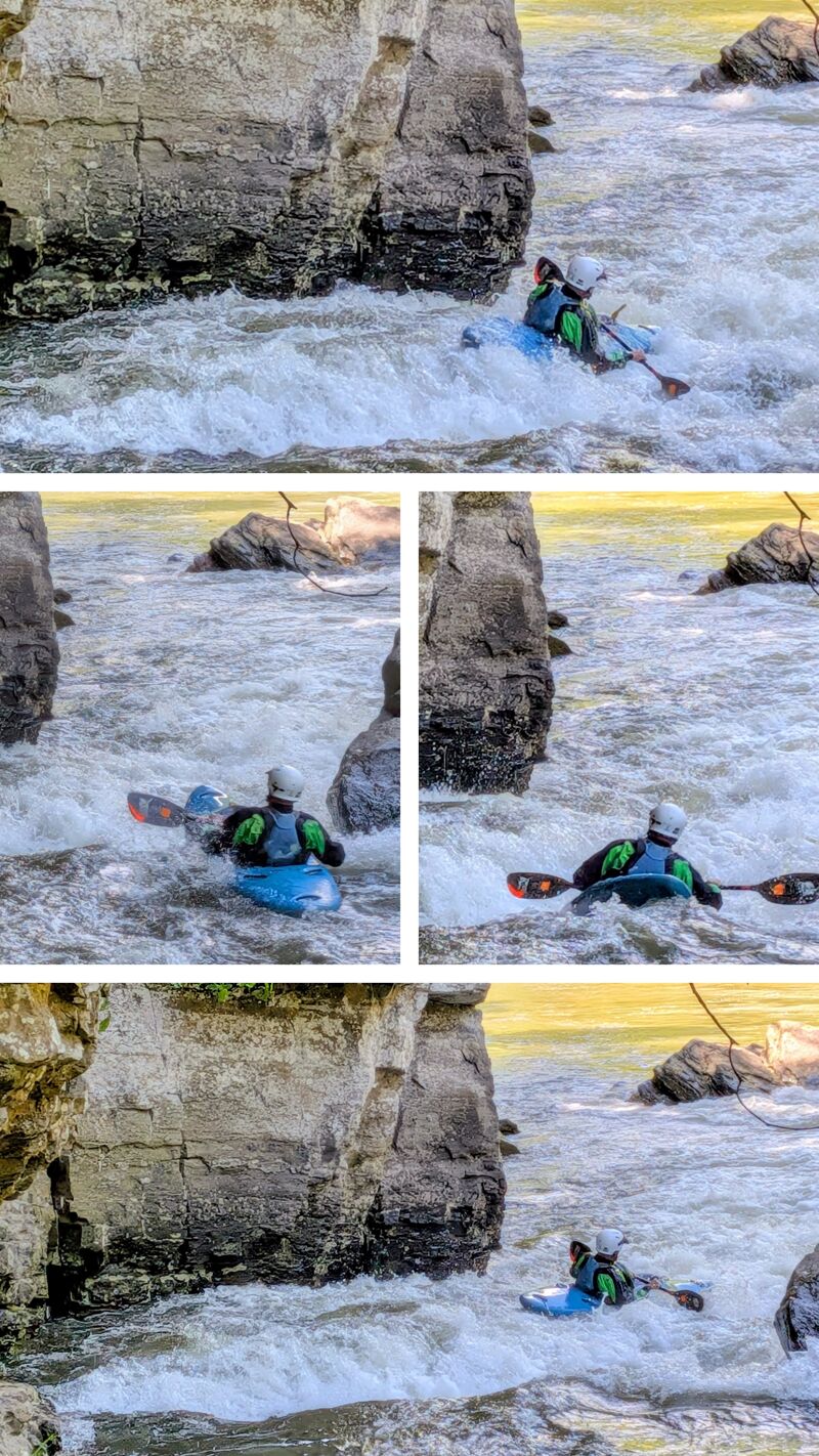
The first rapid as you enter a small box canyon is called Landslide and is more impressive looking then difficult. Boaters unfamiliar with this rapid should scout from river right. A river left boat scouting eddy comes and goes according to how severe the last high water affected it.

For boaters going to Big Bend there will be a portage at a low water bridge about 5 miles from the put-in.

A shorter trip can be made by taking out at 'Eagles Rock', a tall rock face pinnacle on River right. It will come into view once you leave the canyon and into flater water. A short acces road will be to your left with room to leave a vehicle. There is also a gated area but if you decide to use the field beyond it, please be mindful to chain the gate.


River Features

Put In - US 220 Bridge North of Upper Tract

Distance: 0 mi

Put In - US 220 Bridge North of Upper Tract

Landslide Rapid

Class: III+Distance: 0.69 mi
Rapid
Landslide Rapid

Landslide Rapid

Low Water Bridge

Distance: 4.19 mi
Portage
Hazard

Low Water Bridge

Take Out - Big Bend Campground

Distance: 10.11 mi
Take Out
Take Out - Big Bend Campground

Take Out - Big Bend Campground


MB
Mark Brenneman

Apr 21, 2021


Six of ran this section down to the low water bridge on April 20, 2021. The Landslide rapid is no longer blocked by downed trees. While is is now completely clear, it’s still a good idea to scout it because the narrow slot does have the potential to accumulate wood. We ran it at a low level (240 cfs) it found plenty of water in most of the rapids, with only some minor scraping on some gravel bars.

EB
Earl Baer

Jun 8, 2020


We ran this section June 6, 2020. The left side run out for landslide rapid is blocked as described below. the right side run out is open and can be run. If you are comfortable running this rapid you should be fine, scout from the usual gravel bar on river left above the rapid. If you come out of your boat the current will push you into the root ball/tree described in the comment below. Nobody in our crew of six paddlers had any trouble making the right line.

CM

Landslide is still unrunnable as of early May, 2020. The portage is along the opposite bank and, trust me, isn't worth it due to the steep gradient and bushwhacking through poison ivy. I can't emphasize enough that one should put-in below this rapid by skipping the first mile or two of the canyon. I have a tentative plan to go in with a chainsaw in October and liberate Landslide. This run is night and day different from lower Smoke Hole Canyon starting from Big Bend-- whereas in the latter you have one or two class II+, the class III wave trains are abundant and at times continuous in upper Smoke Hole (i.e., this run).

KB
Kolya Belcher

Jul 17, 2018


I ran this section both July 13th and 14th 2018. I am a begginer Paddler with a good bit of talent who's home river is the Yough. I made the mistake of not scouting Landslide at lower water and relied on research. There are at least two massive trees now lodged from the cascade line across both left eddys and anchored on the large rock downstream left. I hit the drop perfect but had already been aiming left and when I tried to carve along the flow right to miss the trees and hole, was sucked towards the trees, went under and couldn't roll so had to wet exit. Thankfully nothing bad happened and just floated my stomper downstream. The rest of this river was a blast to run with no trouble. I skipped landslide the second day.

TC
Timothy Collins

May 27, 2014


A big group of us put in at the 220 bridge and took out at the low water bridge. maybe 5 miles. The gauge was reading 2.7. Two of the canoes had two dogs and two paddlers, and another in the group was in an open touring kayak. Most of us ran the 'landslide rapid' (w/o the dogs), and ended up swimming. Only one canoe made it through upright, they lined up way right. Nobody got banged up here. I highly recommend this float, and I wouldn't worry about open canoes, at this level a bail bucket and some moderate river skills is all you will need.

BH
Brett Hagerty

May 23, 2013


In response to the previous comments about this section - The four mile stretch from 220 to the picnic bridge is a great run for those who are wanting a beginner creek experience. It is class III with some pools but lots of continuous water. Open canoes should consider this an expert run, but it is not class V. Landslide rapid could be considered a III+ at higher levels.

JG
Johnny G

Apr 18, 2012


May 2010: We ran this at 2.75 feet Memorial Day weekend and got worked hard because we made the mistake of bringing open canoes, loaded ones at that, onto the upper section. To be clear to all readers, open canoes have no business above the campground at this level or higher unless you have excellent skills and air bags. More water would have definitely helped, and to be clear, we did not run landslide; we put in below that. Our advice: save those open canoes for the section from the Big Bend campground down to Petersburg, which is a relatively straightforward float at that water level.

Update April 2012: We ran from halfway down upper smokehole (a few miles before Big Bend) down to Petersburg 4/14/12-4/15/12 at 2.25 feet. It was bony but we had very little walking and it was beautiful. With good reading skills and lighter gear, this can be run below recommended, though I wouldnt' run it lower than this. The final rapid at the dam had rebar sticking out but it wasn't sketchy. I recommend anyone running it at this level bring a battery-powered saw and cut that rebar out to do a big favor for boaters at higher water levels.

HS
Hugh Stoll

May 30, 2011


We consider this our club run. We usually run it at least 6-10 times a season. Landslide is usually easier than it looks. Everybody in our group has rolled in it and just flushed right through. We always scout it on the left. Stop on the sandbar and walk carefully along left bank. I'ld call it a IV but only because a line too far left will put a new scratch on your helmet. As always...make your own decision. Shoot me an email if you're a solid class III paddler with a bombproof roll, and you'ld like someone to paddle this section with. hugetroll@yahoo.com

?
Untitled

May 16, 2011


My dad and I paddled this stretch April 30, 201 | [RIVER LEVEL]: 3.9 (at put-in), 3.77 at take-out [PADDLER EXPERIENCE]: Bow (19 y/o f): novice; Stern (56y/o m): experienced paddler | [BOAT]: Dagger caption complete with front and rear flotation, kneeling pillars, thigh straps, and no camping gear. | [PERSONAL GEAR]: Full wetsuits, helmets, and water/tennis shoes. | This stretch was an absolute blast. 9 miles of nearly non-stop class 3 rapids (a few stretches of calm, but there were definitely more rapids than not). Great fun for the experienced. Guaranteed no boredom! [LANDSLIDE RAPID]: This rapid is the first one you'll hit right if you put in at the 220 bridge. At 3.9, this was a raging V. Experienced kayakers, have fun, but to anyone who's brainless enough to hit this in a canoe or as an amateur in a kayak, I seriously hope you've got your will in order. Hey, this is how natural selection works, right? When you see car-sized boulders, pull off to the right immediately (left is a sheer cliff) and portage around or at least scout it. There is a calm place to put in just downstream. The portage isn't the best (about 15 minutes through bramble-infested cliff trails). If you're on the fence deciding whether or not to shoot this, don't. This is not the place you want to have river rescue pull you out. The cliff by the road is high and impossible to climb and pulling out here would be impossible. There is no cell reception, so you'd have go to downstream to a quarter or a half mile to pull out and hope a car comes by to give you a lift. | ['SCHOOL BUS RAPID'] I don't know the official name of this rapid, but there is an old school bus on the left shore, which is why we refer to it as such. There is a sand-bar/island right by the bus. At 3.9 the river was a bit low on the right, so we went left. We got sucked in by the bank and flipped in a solid III. The channel here is narrow, but the water is deceptively deep. at 5'9', I couldn't touch bottom. The current here is pretty fierce and there's another solid III just a bit after which you definitely don't want to swim, so if you flip, get out asap. It's deep, but there are still lots of nasty rocks. My dad and I both came out bleeding from this one. | [LOW WATER BRIDGE]: There is a great stretch of III's right before the low water bridge. Warning signs to watch for are a sign to the left for Smoke Hole Cave (you'll just see the plaque, though), then a broken down RV (if it's still there, but it looked like it had been there for quite a while). You'll have to pull out in the middle of a long stretch of III's unless getting sucked under the bridge is particularly appealing or you. There is not good place to pull out. We ended up grabbing the left bank trying to stop. Good luck. [WHAT I WOULD HAVE DONE DIFFERENTLY]: (1) Worn a light life jacket. My wetsuit provided some buoyancy, but with the current and depth, I would have appreciated an extra boost.
(2)Worn something over my ankles, considering I paddled this over two weeks ago and the four inches between where my wetsuit stopped and my shoes began are still a painful grey/blue from deep tissue bruising and complimented with some lovely battle scars.
(3)Gone with a decked canoe. Especially with higher water levels, there isn't a whole lot you can do in an open boat not to swamp against 3-4' standing waves.
| [ADVICE]
(1)Take this with a grain of salt as I'm still an amateur, but I lost one paddle, so I'd definitely bring an extra even if you're in a kayak, and two or three if you're with a partner in a canoe. You're toast if you're trying this with only one person paddling. Don't forget to strap them in!
(2)Don't touch this if you're not a good swimmer.
(3)Leave the kids at home
(4)Don't make this a training trip for new paddlers. I knew the basics of paddling and still got us capsized 4 times.
(5)Wear a full wetsuit even if the water is gloriously warm. No one plans on capsizing, but if you do, when you get out and see the knicks or tears in your suit, you'll be glad it wasn't your body.

Happy Adventuring!

?
Untitled

May 2, 2011


My adult daughter and I ran this section on April 30, 2011. We put in when the Franklin gauge was at 3.9 (about noon) and took out at Big Bend Campground about 5 PM when the gauge was at 3.77. We were in a 14' Dagger Caption designed for whitewater, with kneeling pillars, thigh straps and flotation bags in front and back. We were in wet suits and helmets. I'm a well-seasoned amateur; my daughter has been down 3 very easy rivers, so still a novice. I read a guide book online that said 'the first rapid below 220 is the best' and described it as a class III. Fortunately, someone at the campground warned me about it (Landslide rapid). We walked around it. It looks like a mankiller to me, definitely a class V. I think a world class kayaker could do it, but anyone less is taking an unreasonable risk with their life.
The portage 'path' on the right is simply awful--high sharp boulder, thorns and brambles, etc. But I'm still glad I portaged.
Not too far above the low water bridge at Smoke Hole the river splits--where an old dilapidated brownish school bus sits on the left. We scouted (as we were driving to the put in) and ran the left side. There is a very large boulder near the left bank with a very heavy flow of water over it and to the right of it. It looks runnable just to right of the boulder, and we tried, but I think a cross current caught us and we swamped, got bashed up a little bit. (If you swamp here, you need to get out fast, because there is another very heavy rapid right ahead where the river re-converges and you don't want to swim it.)
The low water bridge looked deadly--about 6' of daylight between the top of the water and the bridge, with heavy water flow. I could find no good place to get out above the low water bridge. The water is very swift and heavy along the entire length--no eddies, sandbars, banks, etc. We ended up grabbing saplings on the left bank and that finally stopped us, but it was not pleasant.
Otherwise, we had an awesome time. We encountered LONG stretches of non-stop class III waves. We shipped some water in some of the waves (had to pull off and empty out). There were actually not a whole lot of turns to be made--main challenge was picking the right spot and keeping the boat absolutely straight when hitting the waves.
We viewed the river one day before when the Franklin gauge was at 4.34. There were a lot of REALLY ugly looking waves (backward bending whitecaps) at that level. I was highly relieved when the level dropped to 3.9, and those ugly waves tamed down considerably.
We swamped 4 times. There seems to be NO 'good' place to swamp on this river--the fast, heavy flow is practically non-stop. Our flotation bags helped considerably in making the boat more bouyant and easier to pull over to a bank. (There is a quiet pool below landslide falls--for the lucky ones who survive.)
When I do it again, I'll wear a life jacket to supplement the bouyancy of the wet suit. My daugther got scratched up where her ankle area was exposed between where the wet suit stopped and her water shoes begain. Next time she'll have uninterrupted coverage there in case we swim again. I wore Frogg Togg neoprene wader booties (purchased at Gander Mountain) as socks inside sneakers and I was fine.