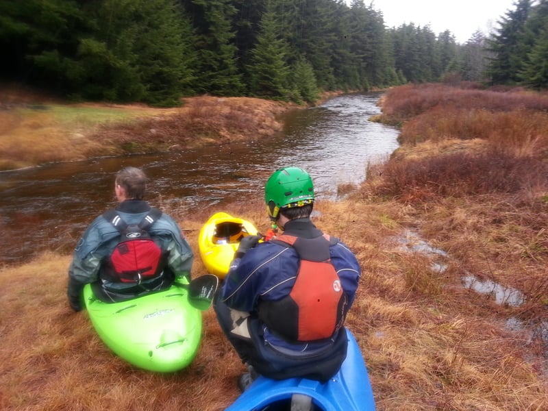
Red Creek
2. D4149 North Branch Bridge to confluence with the Dry Fork
| Difficulty | III-IV |
| Length | 7 mi |
| Avg Gradient | 75 fpm |
| Gauge | Blackwater River at Davis, Wv |
| Flow Rate as of 50 minutes | 42 cfsbelow recommended |
| Reach Info Last Updated | January 30, 2024 |
Sections of this run have been channelized.
If not continuing down the Dry Fork paddlers may take out at the old bridge location about 1/4 upstream from the confluence of the Dry Fork or at the WV 32 bridge another 3/4 mile upstream.
Lat/longitude coords are approximate, from TopoZone.
The put-in for lower Red Creek is at the Laneville bridge. Parking is on the upstream end, where you can carry boats to the creek underneath the bridge.
NOTE: As of summer 2022 the Laneville bridge is closed and will be replaced with a temporary bridge in the coming months.
Take-out - Old Siding Rd. Bridge
Dry Fork Confluence - Paddlers can continue down the Dry Fork to the Jenningston Rd. Access on the Dry Fork.
Mar 25, 2019
Re-visting the accident site (Nancy Kell's) provided some valuable insight on a few unique dangers. The accident took place just below the confluence of Collins Run (river left), there's a very large strainer on the far left side which is easily avoided to the right of it. Below that strainer is where the real danger lies. The left bank is heavily undercut via erosion and develops lots of root balls. The strainers and root balls are cleared out but it's only a matter of time before new ones are uncovered. Stay 10' from the left shore to avoid entrapment along the river side left bank.
May 7, 2018
Paddled this on 5/6/2018. Blackwater gauge at Davis was around 880 CFS when we put on, and rose to around 940 CFS by the time we took off.
Red Creek is continuous and somewhat shallow in places. It felt a lot like the Savage at normal release levels, but beefed up a bit and without all the nice people to cut the wood out for you beforehand. The largest set of drops I remember were about halfway down the run: the river curves to the right and drops over a set of shelves and ledge holes. After that, there's a short break as the river curves back to the left, followed by a straight shot for 100 yards of large offset holes. This section comes to a close when you punch a fairly sticky, almost river-wide hole.
There was a good amount of wood in the run, and though most was avoidable, I portaged one rapid because of it. It is important to be comfortable with boat scouting in continuous Class III on this run; it's almost guaranteed that there will be wood somewhere in it.
This is a run where you need a decent combat roll. It's shallow enough that you wouldn't want to spend a lot of time upside down, and swims will be long and cold. Eddies are very small and sparse, so getting an empty boat to shore is challenging.
Dec 9, 2014
Since we were staying at Old Timberline (behind the gate of ultra exclusive estates), we were able to hike in via the Valley View trail at the top of the hill (next to Timberline). The hike was easier than coming in the traditional way (via Red Creek Campground) and took us about 35 min of mostly downhill (trail 511 towards Blackbird Knob). We put on the Left Branch of Red Creek and were able to paddle the full way down to confluence which (took about 35 mins). The Left Branch was very low and scrappy but never got out of boat and no real wood issue.
Oct 10, 2012
I paddled this May 9, 2012. The water was too low up at the takeout for the upper section, but I put in at the lower road bridge, and the water was barely adequate for a day of new river exploration, checking visually. The Hendricks gauge read 3.9. Parts of this run were nice, and several were too bony, but would have been nice with 6-12 inches more water. The first part had a lot of small boulders. There were several logs to dodge, as well as a massive log jam that needed to be portaged, but which would be possible to sneak to the right with perhaps 2 more feet of water, although that might be risky. Downstream of the highway, there is an island. Due to low water, I went left, whereupon I immediately pinned on a small log that I tried and just failed to claw my way over. Downstream still alongside this island, I broached on a very annoying pipeline---this was rather frightening, and definitely to be avoided; I swam and felt lucky to have avoided death/injury/etc. while keeping all of my gear. With another six inches of water, the pipeline might be under water. Probably best to go right of the island, although the pipeline is probably over there, too, so watch out! Be alert! Somewhere around here (I think, upstream of the highway) there were some beautiful, low-angle sliding rapids on a solid rock streambed. Finally, just above the Dry Fork of the Cheat confluence, there is a super-nasty, evil-looking pourover/hole on the left side of the river against an undercut cliff where the creek jogs right a bit. Definitely avoid this!! All in all, I enjoyed it, but more water would have eliminated most of any unpleasantries that I had. With more water, I can definitely see how this could be solid, continuous Class 4; difficulty depends largely on water level, to answer the comment below mine a bit. I saw very little in the way of Class 2.
Apr 26, 2008
Yes, at low levels this is really an enjoyable class III run, not much more. There are few tricky spots in the first two miles, where the channels are very tight and you have some make some quick turns to avoid the boulders at some minor ledges. Then, around midway, there is a long rapid of low ledges and hydraulics, which is probably the most interesting stretch of the river. You should continue to the lower (old) bridge, or even onto the Dry Fork, because there are good rapids until the end.
Oct 29, 2007
After running this river 10/27/2007 I think that it is difficulty scale is a bit too high. Most of the river is a class II-III, with nothing even approaching a class IV drop. The vast majority of the rapids were of the loose cobble-bar style, reminiscent of the approach to Cucumber on the Lower Yough.
Nov 9, 2002
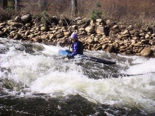
This is the last rapid on Red creek as it enters the Dry Fork.
This is the last rapid on Red creek as it enters the Dry Fork. Check out the full-sized version of this photo by clicking here.