Stony River
2. Route 50 (in West Virginia) to North Branch of Potomac River (Kitzmiller, MD Take-out)(Lower Stony)
| Difficulty | III-IV |
| Length | 15 mi |
| Avg Gradient | 72 fpm |
| Gauge | North Branch Potomac River at Kitzmiller, Md |
| Flow Rate as of 1 hour | 2.19 ftbelow recommended |
| Reach Info Last Updated | May 28, 2025 |
The Stoney is a pleasant little technical stream with some fairly complex rapids scattered through the run especially towards the end. Just before it dumps you into the meat of the N Br. Potomac, Kitzmiller Section, kinda like a version of the Middle Fork / Tygart run. Note that while the run on the Stony is 6.4 miles long, the entire run out on the NB Potomac is 15 miles.
OTHER NEARBY RIVERS:
Gradient, mile-by-mile: 40, 70, 70, 80, 70, 90, and 60 in the last 0.7 mile.
Put In - Route 50 (in West Virginia) bridge over the Stony near Mt. Storm WV.
Take Out - Kitzmiller, MD. Because the Lower Stoney and L. Br. Potomac confluence is isolated, running the Lower Stoney is usually a committment to paddle the bottom 2/3 of the Kitzmiller run down to Kitzmiller, MD
Apr 25, 2011
As of 4/23/2011, Stony is free of wood from Rt 50 down to the North Branch of the Potomac.
Jun 8, 2009
Level between 360 - 390, a very good level---I've done it lower 2 times---but below the 'official' minimum. I flipped under the right side, but portaging left is safer.
Mar 17, 2007
This is a great creek for boat-scouting. I had to shore-scout only one drop--the last big ledge before the Potomac. Speaking of which, if the Stony is running, the Potomac will be cranking! Be prepared. Also, FYI, the takeout at Laurel Run is never really an option in winter, due to extreme icing of the north-facing road.
Sep 22, 2004
Ran this stretch several times over the course of 2003 at several different water levels. This run is one of my favorites, providing a nice training ground for class 4 paddlers to work on their creeking skills. While very similar in nature to an easy Upper Yough, the Lower Stony has alot of variety in its rapids, including several high ledges and slides to break up the boulder garden action. The first 4 miles of the run is continuous class 3, consisting of boat-scoutable boulder drops and ledges reminiscent of the 'warmups' on the Yough. One of these drops is particularly vigorous, beginning with a lefthand turn over a ledge that leads into a series of constricted 2-4 foot drops. Soon the gradient will pick up, and the Stony enters a long stretch of class 4 boulder rapids which make up the most exciting and difficult part of the run. While these rapids are all boat-scoutable, there are a number of undercut rocks and pinning spots to tangle with if you get off line; also, there aren't many eddies, so leave plenty of space between paddlers. About a mile above the confluence with the North Branch, paddlers will encounter a fun three-tiered slide containing several ledge holes and some powerful lateral waves. This last mile of the Stony is tougher than the sections above, consisting of technical boulder gardens and large ledge drops. Upon reaching a small pool and a very distinct horizon line, paddlers will know they have arrived at the single largest drop on the run, a roughly 8-10 foot ledge. This ledge is solid class 4 at all flows and bumps up in difficulty as the flow increases. The best line is down the left, where the ledge is broken into 3 drops. The first drop is a funnel-shaped 2-3 foot drop into a hole, just slightly to the left of an ugly sieve/crack. The second drop runs directly into the first, a 3-4 foot slide over a cheesegrater rock into a pourover. After avoiding the pourover, the paddler is immediately launched over the final drop, a 4 foot ledge into a powerful hole. The runout from this ledge slams into a large, box-shaped undercut boulder about 15 feet down from the final hole; make sure you get over to the right when you finish! In high water the drops run together, creating a mess of lateral waves which funnel the boater into a trashy hole at the bottom. Below here, the run continues over a nother nice slide- which can be mean at high flows due to some large holes in the approach- before dumping into the meat of the North Branch.
GAUGE: There is a gauge on the Stony which monitors the outflow from the VEPCO dam at Mt. Storm lake. While 250 cfs is listed as a minimum, this should be taken as being a 'bare minimum'- we made a run at 280 cfs one day and barely made it down with our Shredders; lucky for us the run gets pretty channelized towards the end. A level of 400-600 cfs on this gauge is optimal for a class 3-4 'creeking' experience on the Stony; this run is also done in the 600-1200 cfs range as well, but the run changes significantly in character, developing fast currents, large waves, and powerful holes- call it 4-4+. A gauge at Rt. 50 also exists, unfortunately it does not get posted anywhere as far as I can tell. This gauge, however, does provide a nice visual indicator; from the put-in the gauge house can be seen on river left about 15 feet down from the bridge- if the 2x4's extending from this silo out into the river are at or below water level, the run is good to go. Unfortunately, the Stony rarely runs; a MAJOR (i.e. hurricane) rain event is necessary to get the wonderful people of VEPCO to put water into this gem (another note: I've heard rumors of the dam operators purposely shutting off the water on people running the Upper Stony, so be VERY discrete when putting on at the dam or else you might be hiking out in an hour). Basically, if the North Branch at Kitzmiller is at 5.5ft and rising, the Savage below the dam is flowing above 1000 cfs, or the Blackwater is outrageously too high, the Stony *might* have water in it.
SHUTTLE: One aspect of this run is that if you don't know where to take out, you must run 10 miles of the Kitzmiller section of the North Branch to reach your shuttle car. However, there is an obscure takeout for the Stony at its confluence, provided you know how to get there. This access is on river left at Laurel Run, near the 'town' of Schell:
- From the Rt 50 bridge over the Stony, head west to Gormania and turn right onto 560.
- Turn right onto White Church - Steyer Road (sign for Laurel Run/Wallman recreation area).
- Veer left onto Audley Riley Road. Road turns to gravel and you enter the state forest.
- Veer left at split and follow gravel road to deadend turnaround next to Laurel Run. You are about 2/10ths of a mile from the North Branch Potomac. To get to the river, ford the creek at the fiber optic cable right of way and walk down the river. There you'll see old bridge abutments and the cable right of way posts as indicators of the takeout, which is shown as Schell on the map. *NOTE*: It is advisable to walk down to the river and take serious note of where the trail to the takeout is in relation to the Stony confluence- this is NOT a good area to get hopelessly lost in.
ONE FINAL NOTE: This run is notorious for picking up strainers and has killed due to this factor. I ran this stretch the day after Hurricane Isabel came through and found no strainers, but I have run into some riverwide blockages in the past. Be careful out there.
Sep 18, 2004
This 4 foot ledge was a fun class 3 drop on river left and an interesting boof over a sticky hole on river right (just out of sight in the picture).
Some offset holes made this a pretty fun class 3 rapid.
The rapids are starting to get a little trickier.
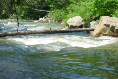
In the background of this picture is a rather mean ledge drop; in the foreground there is a riverwide strainer.
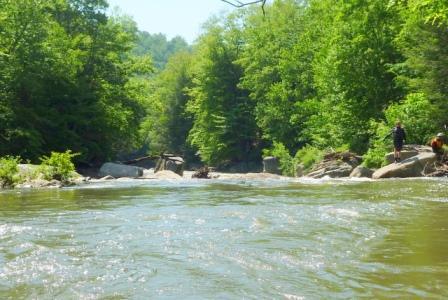
Can you spot both paddlers in this picture? (Hint: one of them is blasting through a huge wave)
Looking downstream into one of the larger class 4 rapids.
This is only part of a long class 4 rapid with some tight slots and big holes. At lower water levels, this rapid presents some tricky pinning spots. If you look carefully, you can just barely make out John sitting at the top of the rapid.
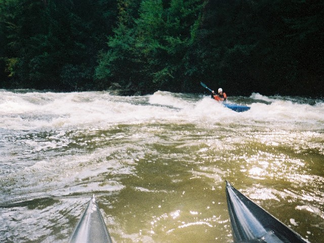
This slide is the bottom drop of the same long class 4 rapid shown in the other picture. This part has some pretty major holes to contend with, such as the one John is about to blast through.
This is the largest rapid on the run- at lower levels, it consists of 3 distinct drops in quick succession. These pictures were taken from the top of a large undercut boulder just downstream from the large bottom hole.
Chris busting through the massive bottom hole of Sawmill Ledge- don't screw up here, or you could get pushed into a nasty undercut!
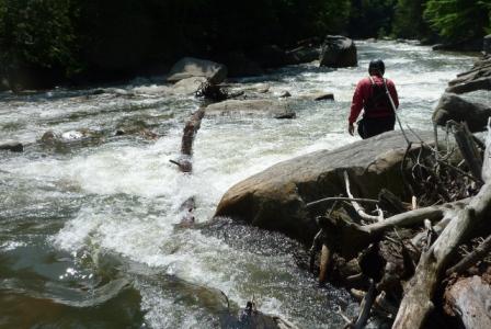
This slide, which is located just downstream from Sawmill Ledge, is about 50 yards from the confluence with the North Branch. The approach to the slide had some major holes, one of which seperated Chris from his boat. The bottom of the slide is surfable at lower levels, but watch out for a nasty left-side whirlpool in the runout.