| Difficulty | II-III(IV) |
| Length | 9.9 mi |
| Avg Gradient | n/a |
| Gauge | South Branch Potomac River at Franklin, Wv |
| Flow Rate as of 21 minutes | 56 cfsbelow recommended |
| Reach Info Last Updated | May 27, 2008 |
River Description
Lat/longitude coords are approximate, from TopoZone.
River Features
Put In
Access PointDistance: 0 mi
Take Out
Access PointDistance: 10.1 mi
Trip Reports
Log in to add a reportSE
Stephen Ettinger
May 1, 2011
A group of us ran this on the April 2011 WV Week of Rivers, starting on Whitethorn Creek just above the confluence with Blackthorn Creek (at which point Thorn Creek is formed), and taking out a quarter mile above the South Branch of the Potomac. There were a pair of barbed wire fences, above and below the confluence, that were difficult to spot but easy to lift up. There are also 4 low-water bridges to portage, 3 of them early in the trip, that are nuisances but easy to spot and portage. We encountered not a single tree strainer, although there was some wood in the creek.
Overall, it is an excellent 10-mile paddle, mostly class II in the first half and up to class III- in the second half, except for 3 places that deserve special attention. The first, not clearly visible from the road, is a 1/4-mile gorge, some 2 miles below the confluence. You can paddle down to above the first of the three, class IV rapids, but then need to get out and scout. On the first hard rapid, the main flow heads towards a dangerous undercut boulder, so most of us either portaged or took a scrapey sneak route along the right bank. Everyone portaged the next rapid, as it had some wood in it. The final hard rapid in the gorge is a long, tight chute with some ill-placed rocks; it too can be easily portaged.
Two miles later, and scoutable from the road, is a class III ledge, just after a pair of easier lead-in rapids. We all ran a bouncy line on the right.
Finally, there is a class IV rapid right at the confluence with the South Branch. It had a lot of wood in it, and the portage involves trespassing across a private lawn. We therefore took out alongside the road above this drop. If you run this rapid, you have to paddle about 1.5 miles down the South Branch (which is pretty flat there).
I think the 800 cfs minimum at Franklin is reasonable (except when levels are falling fast), but the 5000 cfs maximum is probably too high. Unless you know the creek well, you should be very cautious at levels above about 2500 cfs, especially given the risk of strainers.
JD
John Duke
Mar 7, 2004
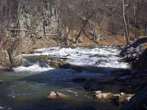
This is where Thorn Creek enters the South Branch of the Potomac..The guidebook calls this an ominous 5 foot ledge,but the drop is at least 15 feet