| Difficulty | I-III |
| Length | 9.5 mi |
| Avg Gradient | n/a |
| Reach Info Last Updated | December 13, 2001 |
River Description
Lat/longitude coords are a SWAG, awaiting someone with better local knowledge.
River Features
Put In
Access PointDistance: 0 mi
Take Out
Access PointDistance: 6 mi
Trip Reports
Log in to add a reportSP
Stan Pitcher
Jul 17, 2017
Hiked up 7-12-17 from Jack Creek and camped near first trail ford. Ran from Red Creek (a little above Venus) to Pitchfork Bridge below Picket Creek. We did 4 short portages (1 above camp, 3 below - all easily scout-able). Gauge at Meetsee was fluctuating between 1000 and 1500 or so. https://waterdata.usgs.gov/nwis/uv?site\_no=06276500 Ranch hand at takeout told us we should have asked permission to leave car near bridge. Some more info on the roadside run here: http://wyomingnaturalist.com/html/river/river\_greybull.html
TT
Thomas Turiano
Apr 12, 2006
Scott McGee and I attempted to run this stretch in Alpacka rafts after hiking over from Wiggins Fork in late May 2004 at about 200cfs.
Unfortunately, I was not aware of the stream gauge at that time and was just counting on a good spring runoff. The weather however was colder than I expected, and we received about a foot of snow during our ski traverse to reach the put-in.
We did not have enough water for an enjoyable float, and had to walk a good portion of the stretch.
The stretch begins at Venus Creek with wonderful class 1-2 braided channels/pools. After a mile or two, it enters a gorge and becomes steeper, more bouldery, and sustained. The boulders are round and smooth. Many of the boulders are refrigerator size or larger, with fun slots between them.
There was not too much wood on the stretch, except for one or two major log jams about a mile down the gorge requiring portages.
The stretch from Venus Creek to the Jack Creek trailhead is at least 11 miles.
Thomas Turiano
TT
Thomas Turiano
May 15, 2004
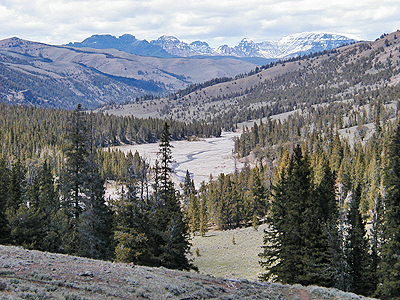
Down below is the Greybull River running through a flood plain below the gorge where Bonne Creek comes in. Venus Creek comes in below that flood plain.
This is very typical of the river as it runs through the gorge below Venus Creek. This was taken a mile or two above where Anderson Creek comes in. We floated a good portion of the river and then gave up. You can see the high water mark in the vegetation...another 2 to 4 feet.