Covel Creek
E1800 (E.18th Rd.) to Hwy.71 (6.5 miles)
| Difficulty | II(III) |
| Length | 6.5 mi |
| Avg Gradient | n/a |
| Gauge | Mazon River Near Coal City, Il |
| Flow Rate as of 56 minutes | 26 cfsbelow recommended |
| Reach Info Last Updated | February 6, 2025 |
Do not park or put-in on upstream side of E1800 (18th Road) bridge, and do not paddle upstream of bridge, at request of property owner.
Alternate put-in is near Pine Hills Golf Course near Stoneyville. (Beware golfers with a mean slice on 4th hole!)
This can be a lot of eddy hopping and surfing fun if you catch it when other rivers in the area are starting to come up (Vermilion) or are running good (Little Vermilion). Due to the small watershed it's normally the first river in the area to lose boatability after a big rain. It normally takes a good rain (2 inches or so in one day) to get it up to the 'higher' levels which can be a BLAST! When there is sufficient water, this makes a fast fun warm-up or 'chaser' for a run on the Vermilion. Much swiftwater, riffles and rips, and a few good playable rapids.
A user warns (Aug 24, 2018):
At the second busted low head dam once you get to the golf course, [at] the island ... don’t go right unless you have a chain saw and a crew of guys to clear out the mess!
Our reference gauge for this run is the Mazon River (another tributary of the Illinois River, more-or-less parallel to Covel and about 30 miles to the East). At its gauge, the Mazon has drainage area of 455 sq.mi. vs 63 sq.mi. at the put in for Covel. Thus, flow here may be just over 1/8th (0.138*) the flow on the Mazon gauge. For what it's worth, using the full history of this gauge, flow only exceeds 914 cfs 10% of the time (I.E., roughly 36 days a year). With our presently listed guess on the minimal baseline for runnability here (1600 cfs at Mazon, likely corresponding to roughly 200 cfs on Covel), figure that means likely fewer than 18 days a year (on average) for Covel to be runnable. (Small drainage flashy creeks such as these likely have runnable periods measured in hours, rather than days.)

Drainage area at our listed put-in is approximately 63 sq.mi. (as calculated via USGS StreamStats Beta software).
Roughly a 1/4 mile from the put in, this is the first constriction and gradient you'll come to. A few small pyramid waves at low flows and bigger waves at high flows, it has an eddy right behind a rock on the left side that can be used to try some ender moves, or at higher levels this rock can be boofed, but that's the extent of the excitement in this area.
It gets this name from the metal targets setup in the back yard on river right, just after you reach this small class 2- rapid. Knowing that the shooting targets are there and the river left bank/ledge is the backstop for errant shots, you may want to use caution if you hear gunshots (or what sounds like fireworks) before you get there. If you should hear shooting sounds, definitely use your whistle or make yourself seen! The last thing we want is a shooting accident on the river! (That said, I've never seen or heard any shooting on my probably triple digit worth of trips down this river.)
After the Shooting Range, the river is mostly boulder bed with a few constrictions that may be surfed but will probably just be floated through, until you get to the Oyster Wave, one of the best surf spots on the river!
Shortly after the shooting range, water picks up speed, with a few boulder bed rapids to boof or avoid. You'll start to see branches hanging low (almost into the water) on river left.
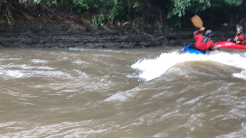
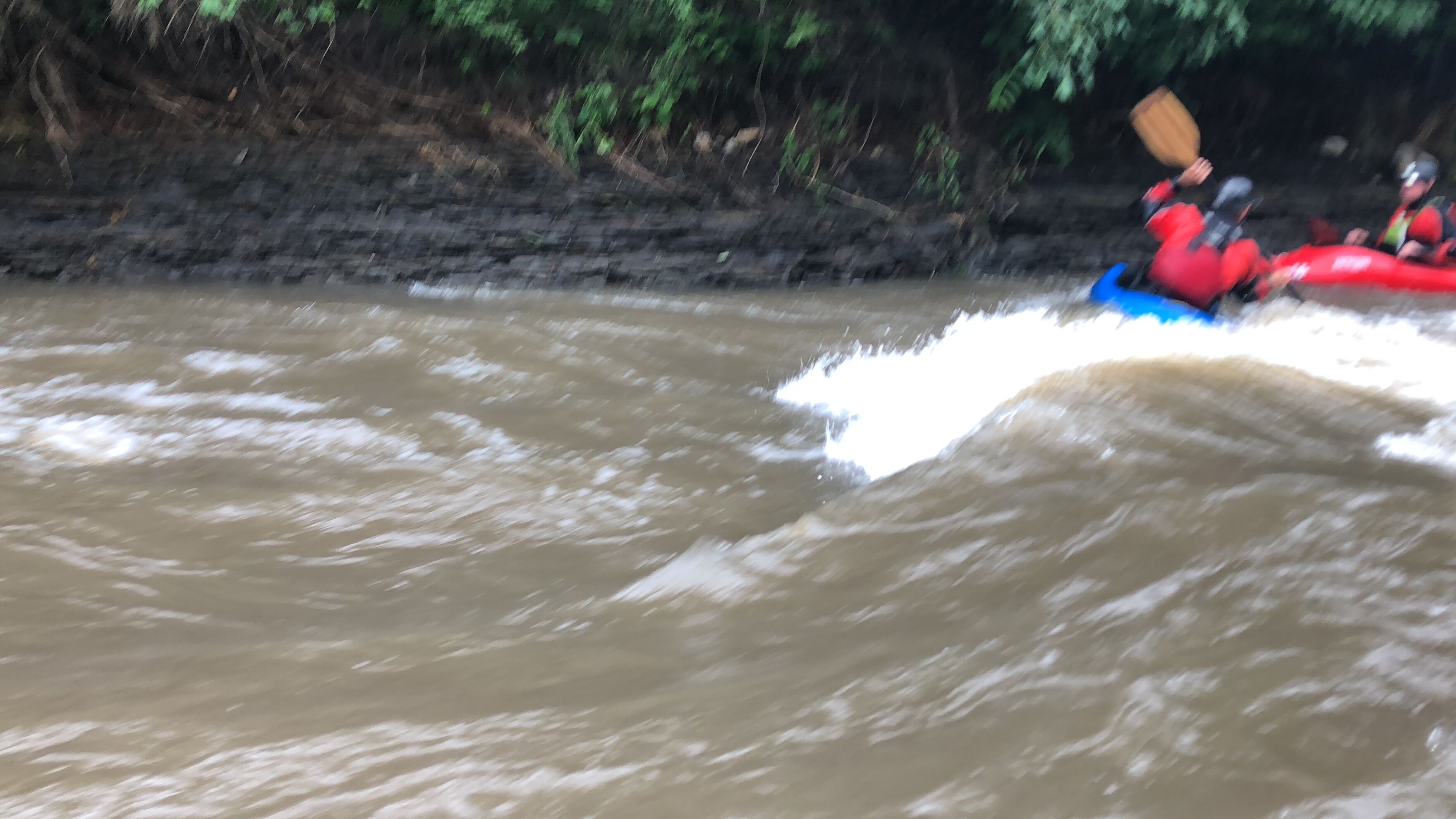
The river splits to the right (maybe 1/5 of the flow going to the right) just before a rock outcropping on the right. This constricts the flow and has about 10' of gradient over 30', creating the first wave/hole (depending on the level) where you should see a smiley face shaped foam pile (from surfers view) and possibly 6-9 pyramid waves after the foam pile (depending on flows). It's surfable at many flows, but a medium flow seems to be best for this wave.
You can catch the Oyster Wave on the fly if you paddle hard upstream and catch the tallest section of the foam pile. Eddy service from both sides allow you to re-attain the surf as many times as you want, making this a popular location when the creek is running! A great wide trough allows you to work back and forth, spin, loop (only seen the loop done here once!) and get really good play if you watch out for 'the Brown Pearl'!
The Brown Pearl is a section of the Oyster Wave about 3/4 to the rock outcropping on surfers left. You'll notice the river wants to pearl over and push your bow down. Knowing it's there and working with it, your fine, but if you aren't paying attention it will end your surf session and give the next boater in line their turn at the wave!
If you do get pushed out, you can surf the first few pyramid waves (at the right levels), but they aren't near as fun. You're better off getting back in line for your next go at the Oyster. Both eddy's are very long, so unless you come out of your boat, you should be able to get back to one or the other. The easiest side to drop into the wave is river left, as it's a straight forward few paddle strokes to drop into the wave in control and surf until your content. Tree roots sticking out and rocks to hold onto help you keep your place in line.
The river right eddy can also get you into the wave, but you will have to paddle hard and not get pushed out by the Pearl in the wave (which would be about 1/4 of the way in when you drop in from river right), and which will be between the drop in and the best surf section of the wave (the river left side of the wave to the Brown Pearl).
The Wing Man Wave can be seen easily as you approach it, due to the river being constricted down to about 1/3 it's width by a large bank of rock on river left, which creates the contriction for the wave.
The easiest way to catch this wave is to hit the eddy just above the wave (about 15-20 foot) on river right, then peel out paddling upstream to easily catch the foam pile and surf until your content. At best surf levels, this wave has a great foam pile but may be a touch flushy in the center, with great surfing troughs on either side (probably 30' wide, split into to 15' wide waves to either side). Boaters can let others solo surf first, or drop in to share the wave between 2 or 3 boaters, but you may get pushed out or not be able to do any fun moves with more than 2 boaters (you and your wing man).
The wave is best at medium to lower flows, and washes out at higher flows. At best surf levels, reattainment can be difficult. A rock (affectionately known as 'Cock-Block Rock' by the locals) blocks you from downstream on river left, and river right is all rocky bluff with swift flows. If you want repeat surfing, you will need to carry up the river-left sand/stone bank to put in above the wave.
(Merely a waypoint. This seems to be labled a number of different things on various maps.)
Very shortly after this road bridge you will be entering Pine Hills Golf Club.