Split Rock
Superior Hiking Trail to Hwy 61 (2.9 miles)
| Difficulty | IV-V |
| Length | 1.8 mi |
| Avg Gradient | 132 fpm |
| Reach Info Last Updated | May 16, 2022 |
Land around both East Branch and West Branch is posted against trespass. Some boaters on the East Branch have encountered a gun toting land owner with an ATV who has been known to escort groups until they are beyond his property.
As a result, access is often via carrying/dragging up a good trail (starting about a quarter mile the other side of the river/bridge from the wayside/parking on Hwy.61). It is a long, sometimes strenuous hike, but once you see the river, you'll realize why most think it's worth it.
When doing this trail, put-in above a great sliding, twisting drop where the Superior Hiking Trail (SHT) used to cross the river. That footbridge was washed out in a flood, but the bridge footings are still evident, and a sign directs hikers to a new footbridge a half mile upstream. (Spring of 2001, that was also swept off its footings. How many rebuilds until they figure a way that periodic flooding does not rip it out?)
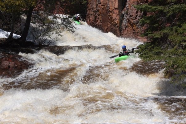
The run has an amazing assortment of big sliding drops. All are runnable (at favorable levels) by boaters with confidence and skill. Most are surprisingly forgiving, in spite of their impressive size.
The final drop is probably of the most concern. A steep, broken slide leads to a wall of rock which diverts the river ninety-degrees left, through a somewhat narrow slot, to spill across shallow splines of rock and large boulder rubble before the calmer water below. The usual route slides down the right, into the 'elbow', then slides along the right-side rock wall (avoiding potential piton rocks to the left in the final chute), then rock-dodging through the pool below.
Downstream from here there is barely more than riffles, rips, and shoals, so fish (and people fishing) tend to congregate below this drop.
Click link for video showing access via one of the branches, and all of the major drops: https://youtu.be/_TAEnA6cUJA
A substantial paved parking lot sits on the northwest side of Hwy.61 right at the river crossing.
The Superior Hiking Trail provides great access to the river, from which you can readily scout nearly every drop as you hike.
Limited roadside parking is available at a trailhead on Hwy.61 where the Superior Hiking Trail crosses (about 0.3 mile northeast of where the Split Rock passes under the highway, where a paved parking lot exists).
While you can carry up from here, this access does not let you preview (scout) any but the uppermost rapids you will run.
As mentioned above, put-in is most often via carrying up the Superior Hiking Trail to a point where it crosses the river.
More rapids do exist upstrream of the bridge crossing (for those willing to bushwhack a bit to explore them) but none are as big and dramatic as those downstream of the bridge.

At our listed (carry/drag-up) put-in, drainage is approximately 39 square miles (as calculated by USGS StreamStats Beta software).
Check out this helmet-cam video (4:16 total, beginning with 35 seconds showing the paddle-in via one of the branches, rather than the carry-up): https://youtu.be/\_TAEnA6cUJA
As you finish the final drop, the gradient peters out. The final 3/4ths of a mile is generally flatwater in braided channels until you reach Lake Superior.
The Superior Hiking Trail is alongside river-right, and offers an option of hiking out that final distance, but why not float to the finish and celebrate your run with a roll in Lake Superior!
Take-out is at a beach upon reaching Lake Superior, where it is a tradition among boaters to do a celebratory roll for continued good runs.
While this river has not suffered the same 'improvements' by the DNR as some other local streams (dynamiting the beautiful slides to transform them into stepped fish ladders), it still manages to inflict it's share of damage on boats. It is not entirely uncommon for someone (out of a group of paddlers) to end up with a major gash and leak in their boat (a split boat from the Split Rock). (North Shore paddling can be hazardous to your pocketbook!)
