Falls
Mead Rd to Lake Superior (L'Anse) (2 miles)
| Difficulty | III-IV+ |
| Length | 2.3 mi |
| Avg Gradient | 155 fpm |
| Gauge | Falls River Near L'anse, Mi |
| Flow Rate as of 54 minutes | 24 cfsbelow recommended |
| Reach Info Last Updated | December 26, 2022 |
Quick Facts
Location: L'Anse city limits to Downtown L'Anse
Put-in: 46.729810, -88.444458 (Mead Road)
Take-out: Falls River Parking L'Anse MI (S.Main Street)
Shuttle:: 3.3 miles/7 minutes
Video Link: https://youtu.be/IUij1IEZE4A
Put-in elevation is approximately 890'
Take-out elevation is approximately 600' (mean Lake Superior elevation).
Total drop is approximately 290'
Gradient: Average: 155 FPM; Max Full Mile: 175 FPM
IMPORTANT NOTE: Gradient values should be used for general comparative purposes only! Differences (even up to 15-20% and more) mean very little in the grand scheme of whitewater! (Streams with gradients in excesss of 50 FPM may be swiftwater with no meaningful rapids!)
Class/rating can also mean relatively little. Short, not overly complex rapids may be rated as III or IV (or even V), and may be run by inexperienced boaters without serious mishap! Conversely, there are complex, technical class II boulder-garden rapids which often cause upsets, injuries and even death among inexperienced boaters! Never rely solely on class/rating to decide if you should run a river/rapids!
Far more important than either gradient or class/rating are other less-quantifiable 'character factors' such as: (1) continuous versus pool/drop, (2) wide-channel with multiple routes versus narrow channel with essentially one route, (3) straight-shot routes versus complex technical maneuvering-required routes, (4) gradual river banks versus rocky shores or steep-walled gorges, (5) heavily wooded (prone to strainers, sweepers, deadfall) versus just shrubs, grasslands, or non-vegetated surroundings, et cetera.
Character: Pool/drop (at normal flows), just about the greatest assortment of drops (slides, verticals) in a short in-town run; 'intro to creeking' run.
River banks: Generally steep rocky mini-
...
Using the upper put-in has two advantages.
One: the road is much better maintained than the road to the former dam site (which, in early/wet season can be snowpacked or a total mud pit).
Two: You get a little more 'warm-up' before getting to the bigger tougher drops on the run.
When the former-dam put-in is reasonably accessible, some boaters may opt for the shorter run, concentrating on the main gradient, foregoing the one or two smaller drops on the upper part of the run and the 'boogie water' down to the site of the former dam.
Virtually all trace of the former dam have been removed. In its stead, the river is lined for a short stretch with trucked-in boulders to stabilize the banks. No falls, ledges, or significant rapids exist through that stretch -- only boogie water. Thus, many boaters opt to put in at this point, forgoing the one upper drop.
The gauge is at this point, and while it doesn't list drainage area, by my best calculation, it appears to be very near 44 square miles.

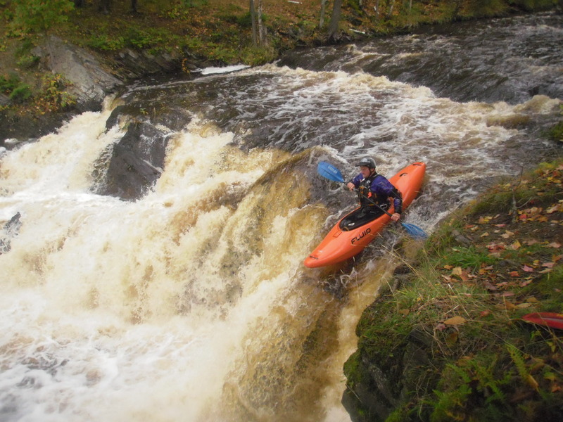
A long, usually shallow/grungy lead-in rapids pitches increasingly downward leading to the site of the powerhouse immediately on the river-right bank. The first of the more 'significant' falls lies immediately adjacent to the old building. Center and river-right all have broken pitch dropping mostly onto shallow rock, and are therefore highly recommended to avoid. River-left above the falls is a small eddy from which one can 'stage' to take a few quick strokes and 'boof' the falls.
This list of rapids is very incomplete, and the specific location (of the indicator on the map) is likely way imprecise. However, we felt it important to mention what is certainly not the biggest drop on the river but what is (perhaps) the most perennially troublesome drop on the river. By the way, the name comes not just from boaters, but from the locals who use the various 'holes' in summer for swimming. This is why it is two separate words (Ass Hole), not just one word (Asshole).
The clues that you have reached this drop are seeing a house on river-right, and seeing the river squeezed between a large hump of rock on the right and a much smaller and lower hump of rock on the left. The flow is funneled into a crease, and drops into a brief pool below. Only a couple boat-lengths downstream, the current pillows against a large rock ('Hemorrhoid Rock', 'cuz it's a real P.I.T.A.), backing up the flow, making the hole even more sticky. The usual route is to start from well-to-the-right in the pool above, charging hard to the left as you hit the crest of the drop, trying to charge hard toward the eddy to river-left of the hole. Make sure to paddle out upon landing, lest you get sucked back into the hole! There are epic tales (and videos) of boaters who didn't quite make the eddy, leaving them and their boats recircing in the hole and the 'room-of-doom' on the right. Rescue is not easy from there.
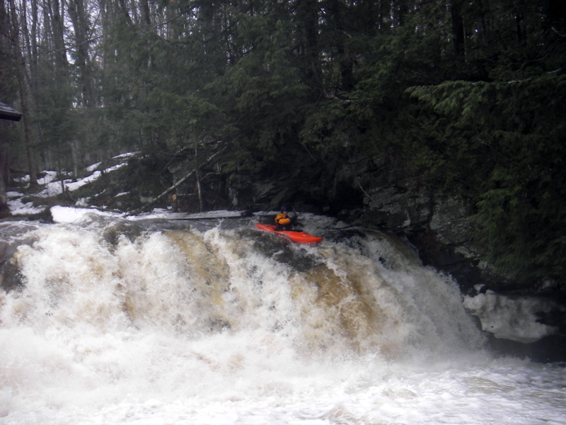
Downstream, a great wealth of ledges, slides and falls await. As stated elsewhere in the general description, the best advice on almost everything is stay to the left on all major drops and gradient.
Historically, many boaters would take out at the highway, forgoing the final series of gradient. Less adventurous boaters (or those who may have 'bitten off a bit more than they could chew' and who have been somewhat beaten-up by the river on their chosen day) may still wish to use this spot to get out.
Most boaters will want to continue under the highway and the railroad bridges (through random small ledges and wrapping waves) for a fantastic finish to the run.
USGS had a sampling site below Hwy.41, listing drainage of 47.9 square miles.
The first big slide below the highway and railroad bridges (as has already been advised for much of this run) is usually run well to the left shore.
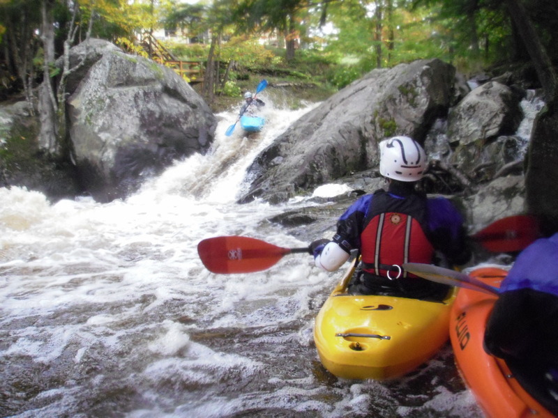
A brief rest brings up a second, lower-angle, round-the-bend (to the left) slide. Usual route on this is trying to stay to the center, angling to the left as the drop sweeps 'round the bend. Alternate route (with adequate water) is to stay to the right partway down, to drop a boof at the end.
Many paddlers will paddle out into L'Anse Bay (Keeweenaw Bay) for a celbratory roll before carrying up to the parking lot.
The final drop is an old dam. The shoulders of the dam remain (to left and right), so all water (at most flows) pours through a center notch and lands on reasonably 'cushioned' bedrock below. You will be pushed hard to the left, toward a wall of rock, and rebound to trip downstream over a few remaining small ledges, waves, and holes. The shores through here are vertical metal walls, until passing under a small bridge and out into the bay, where a beach allows easy exit from the river.