| Difficulty | IV(V) |
| Length | 3.9 mi |
| Avg Gradient | 160 fpm |
| Gauge | Town Creek Near Geraldine Al |
| Flow Rate as of 1 hour | 11 cfsbelow recommended |
| Reach Info Last Updated | June 10, 2021 |
River Description
Note: This page historically contained data for two Dry Creeks, one on the South Sauty Creek watershed, and one in the Short Creek watershed. It has been updated to reflect information only for the Dry Creek in the Short watershed.
Dry Creek is usually just that. With a tiny watershed of 7.2 sq. mi., you need a big rain event and impeccable timing to catch this micro creek. The intrepid boater will be rewarded with a big (BIG) slide drop and two miles of tight III/IV creeking before being deposited on Lake Guntersville.
Access is fairly simple: a small side road near the Martling Road bridge offers easy parking and water access. The takeout is the same as for Short Creek, at the AL 227 ranger station on Lake Guntersville. At least the lake paddle is shorter, since Dry dumps into the lake about a mile after Short does.
There is a faded painted gauge on the downstream side of the Martling bridge. According to Alabama Whitewater, 0'' is scrapable, 4-6'' is ideal, and 12'' is high. There is now an online gauge for the nearby Short Creek, operated by the non-profit entity Streambeam. Like any micro, developing a correlation to other gauges is difficult at best, but this gauge can serve as an indicator: if it's spiking or holding high, you might be in luck for Dry Creek. The online gauge can be accessed at the link below.
https://www.streambeam.net/Home/Gauge?siteID=1
For further information and photos, see the Alabama Whitewater:
http://www.alabamawhitewater.com/guide/guide_files2/dryshort.htm
River Features
Put-In (Martling Road)
Access PointDistance: 0 mi

Put in at the Martling Road (CR 409) bridge, and check the gauge while you're there. You'll be tweezing through bushes for a few hundred yards, and probably dodging logs for the whole run, so make sure to think skinny thoughts!
1st Rapid
OtherClass: IIIDistance: 0.2 mi
The first rapid you come to is a decent sized low angle slide, dropping maybe 20 feet in 40 yards. As of now there is a log at the bottom that you can just squeeze under at 6''.
2nd Rapid
OtherClass: IIIDistance: 0.5 mi (approx.)
After some more boogie and tree/log dodging, the next rapid worthy of note is in a right hand horseshoe bend of the creek. Fairly simple, stay left around the outside of the turn. Easy scouting eddy on the right at the top.
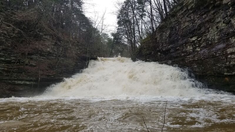
Dry Creek Falls
Waterfall / Large DropClass: VDistance: 0.6 mi (approx.)

After some more boogie, the creek will neck down and quickly drop out of sight. Several eddies exist on the right, as well as an old wooden sign to warn you of imminent danger. Take one of the right eddies to scout. Portaging would be very difficult but is apparently possible, and setting safety would require a big hike.
The line is center-right the whole way down. A shelf extends through the entire left side at the bottom of the falls, and is quite painful to hit. The right side has a series of mogul-type bumps which break up the drop into less abusive pieces. Make sure to stay upright! Fortunately there's a big pool at the bottom.
Class IV Stuff
OtherClass: IVDistance: 1 mi
According to AL WW, there's some good class IV buried in the gorge below the falls. We hiked out shortly after the big one due to a bad line, so no description for these yet. Will update when possible.
Lake Guntersville
Access PointDistance: 2.3 mi (approx.)
Eventually you'll dump into Guntersville Lake. Hang a right when you get there, and paddle out to the boat ramp. You may want to do a roll or two, to wash the water off from Dry!
Trip Reports
Log in to add a reportKK
Kellis Kincaid
Jun 12, 2019
We partially ran Dry on Feb 22, 2019, when the StreamBeam gauge on Short proper was holding at 7.8'. It had just quit raining, and the Dry gauge on the bridge was reading 6'. This seemed like a great level, not too scrapey or pushy anywhere. Lots of wood down, but we were able to duck or avoid everything above the falls. Can't comment on the condition below the falls, as I had a bad line there and we had to hike out shortly after. Probably needs some chainsaw attention pretty badly.
As a side note, some of the info on this page was associated with the Dry Creek in the Sauty watershed. I've tried to remove it where possible. Thanks.
KK
Kellis Kincaid
Jan 1, 1900
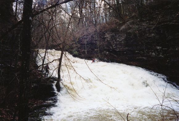
Dry Creek Falls. Hard to see it but there's a bad shelf on the whole left side. Stay center right for best results.