| Difficulty | II-IV |
| Length | 9.4 mi |
| Avg Gradient | 43 fpm |
| Gauge | Sturgeon River Near Sidnaw, Mi |
| Flow Rate as of 56 minutes | 57 cfsbelow recommended |
| Reach Info Last Updated | February 20, 2015 |
River Description
Put-in is from a roadside park on Hwy.41
The main feature on the run is Tioga Falls (about 2 miles downstream).
Take-out is after a L-O-N-G paddle out on the Sturgeon River.
(While our rapids/features list includes waypoints and rapids down this stretch, our gradient statistics cited above are ONLY for the Tioga, and do not include this paddle-out).
River Features
Put In
Access PointDistance: 0 mi
Foot-bridge
OtherDistance: 0.2 mi

Before putting on, check for clearance under this footbridge, and into/through the Hwy.41 culvert.
USGS sampling site
OtherDistance: 0.22 mi
USGS lists a sampling site at this location citing drainage area as 18.5 square miles.
Trail Bridge
OtherDistance: 0.25 mi
Before putting in, check clearance under this bridge.
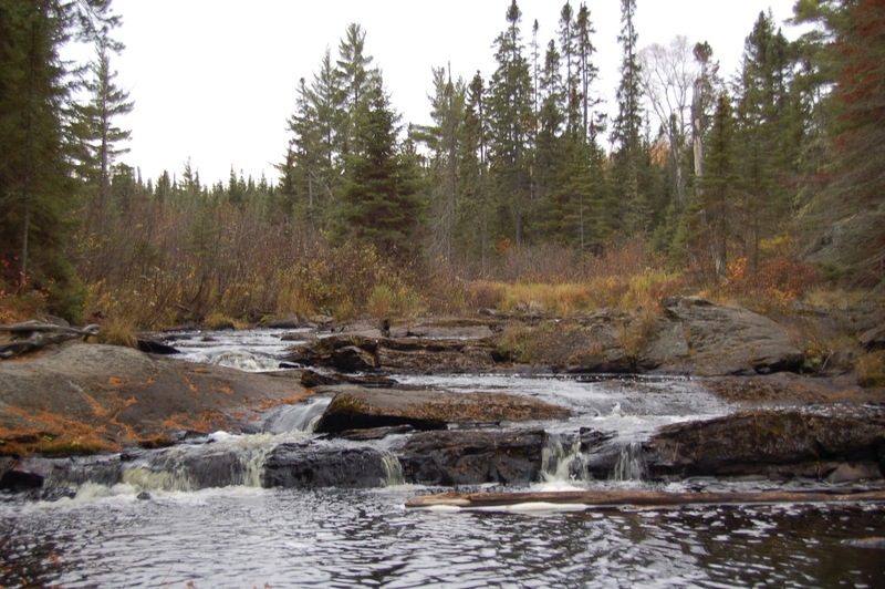
It should be noted that many people may mistakenly believe that the minor rapids they see from this bridge in the wayside park are 'Tioga Falls'. They are not! These are (to the best of our knowledge) just an 'unnamed falls' on the Tioga River, as shown in the photo above, and on the website FishWeb.
Action eases (flatwater)
OtherDistance: 1.16 mi
Action subsides, as the river hits low floodplain and meanders.
Warning shot
OtherDistance: 2 mi
The first little bit of rapids after nearly a mile of flatwater signals you have nearly arrived at the main event.
Tioga Falls
Waterfall / Large DropClass: III+Distance: 2.1 mi
You'll know you are at Tioga Falls when you see a cabin on the immediate river-right shore. (This cabin is a rental unit! Check it out, with great photos of the REAL falls, at: Home Away Vacation Rental.)
End of Tioga Falls Sequence
OtherDistance: 2.22 mi
Online maps appear to show a truck-trail not far from the river down here. If it is not gated or posted against trespass, it may be possible to set a shuttle down to this point to forestall having to do the long paddle out on the Sturgeon.
Confluence, Tioga/Sturgeon
OtherDistance: 2.72 mi
(NOTE: below Tioga Falls, the river hits an area of low floodplain, where it meaners through marshy swampland. At runnable flows, it may be possible/likely to cut off various loops of these meanders. As a result, distance listed here and after may be affected.)
Rapids
OtherClass: IIIDistance: 7.28 mi
After 4.5 miles of dead-flat water, a very welcome (if brief -- 0.2 mile) rapids will be encountered.
Dam/Weir?
HazardDistance: 9.24 mi
A small weir/dam appears to exist at this point. It is likely that (at flows required to run Tioga) this will be a 'non-event', awash in flow with perhaps no sign of its existance. However, in case that assessment is wrong, be alert. It is possible it may (at some flows) create a keeper hydraulic . . . or . . . maybe a playable feature (for those who know the difference).
Take-out
Access PointDistance: 9.34 mi
Take-out (or continue)
Access PointDistance: 9.35 mi
The listed take-out is at Old US Hwy.41. However, if you have allowed yourself sufficient time, you may wish to continue to enjoy these light splishy-splash rapids which continue another 1.5 miles to (new) US Hwy.41.
Trip Reports
Log in to add a reportNo trip reports yet.