| Difficulty | I-II(IV) |
| Length | 1 mi |
| Avg Gradient | 60 fpm |
| Gauge | Vermilion River Near Leonore, Il |
| Flow Rate as of 55 minutes | 4.03 ftbelow recommended |
| Reach Info Last Updated | March 13, 2025 |
River Description
Quick Facts:
Location: 2 miles SouthEast from Oglesby, or 5 miles SouthEast from LaSalle.
Shuttle Length: usually carry-up, 2/3 of a mile. (See details in description below.)
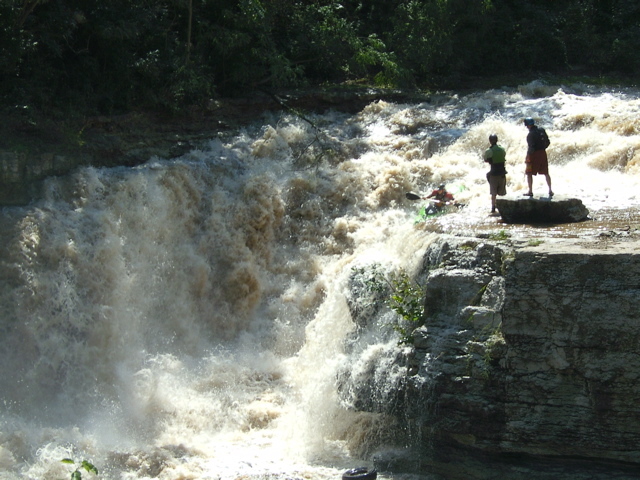
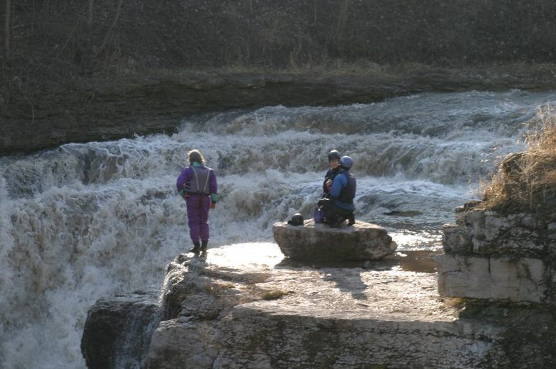
Character: A steep (not quite vertical) waterfall, and runout.
Put-in is approximately 539' elevation.
Take-out is approximately 469' elevation.
Thus total elevation change is approximately 70'.
Video: https://youtu.be/qiiFmeFWY5Y?feature=shared&t=169
General Overview
Bailey Creek is a tributary of the Vermilion. While it can be done on its own (using the put-in listed on this description name), the section above the falls is nothing but strainers with knee deep mud portages. Thus, Bailey is more often done as a side-trip while running the Vermilion.
Bailey Falls (in its present condition) is not a natural formation, but the result of quarrying. Click here to see a stereoscope image of Bailey Falls before it was quarried.
Bailey Creek is now part of the ILDNR properties, but has not yet been officially cleared for public access.
A third of a mile downstream of Wildcat Rapid, look for the mouth of Bailey Creek on river left. The hike up is about two-thirds of a mile on decent trail. From a gravel beach just past the mouth of the creek, go uphill about seventy-five feet to a dirt road. Turn right (away from the creek) and go another eighty feet to a small path ascending to the left. After 150 yards this path encounters a dirt road. Double back to the left on this, and hike a quarter-mile to a fork in the path. The left fork leads down to a large culvert in the river (referred to in the river description below). Bear right at this fork and continue another quarter-mile to the falls. (Partway along this stretch, a path/road
...River Features
Put In
Access PointDistance: 0 mi
Drainage: ~33 sq.mi.
OtherDistance: 0 mi

Drainage area at our listed put-in is approximately 33 sq.mi. (as calculated via USGS StreamStats Beta software).
Bailey Falls
Waterfall / Large DropClass: IV+Distance: 0.6 mi
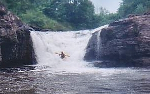
It's not quite vertical, but pretty big and interesting (potentially intimidating). The landing zone is shallow, so have a good 'boof'.
Culvert
PortageHazardClass: IVDistance: 0.88 mi
Due to being completely blocked by trees, this culvert is a serious hazard. Significant flow leads toward the snags, so utmost care and control are needed to avoid disaster. (The 'class IV' rating is primarily to point out the danger of taking this too lightly. IF the trees were ever removed, this would be nothing more than a swiftwater lead-in and an easy hole to punch coming out of the culvert -- maybe class II.) Portage (usually on the right), then check for how playable the hole formed by the outflow from the culvert is.
Take Out
Access PointDistance: 1.04 mi
This is not really a 'take-out', but rather it is the confluence with the Vermilion River, which boaters will run to its take-out.
Pickup Truck
HazardClass: IIIDistance: 1.14 mi
This is the last bit of drop before encountering/returning to the Vermilion River. Rocks generally block river-right, and the frame and wheels of an old pickup truck lay in the riverbed to the left. (You DON'T want to mess with that!)
Trip Reports
Log in to add a reportRS
Rob Smage
Oct 26, 2018
YAHOOOO!!!! *********************************************************************************************************************
As of Oct.25, 2018, the state of Illinois has purchase the BUZZI UNICEM property to add it to Matthiessen State Park and Starved Rock State Park. *********************************************************************************************************************
http://www.newstrib.com/free/springfield-acquires-buzzi-property-for-million-video/article\_203e37f8-d89a-11e8-9a7e-e72ef52ec0d6.html?fbclid=IwAR0Ry4xcff6cheH1HIIlR43f0OufMURYJNTq1rcGbVIXW5ddXwhac7Qpd2E
\\\*******************************************************************************************************************
The above article does say 'The project will indeed bring Bailey’s Falls, Wildcat Rapids and a number of ponds and wooded areas into the public domain, along with expanding access to the Vermilion River for boating and rafting.
It will be some time before the public can set foot in any of the newly-acquired areas.
Kerry Novak, complex superintendent for Starved Rock and Matthiessen, said the agency will have to conduct a number of time-consuming assessments to ensure wildlife is protected and to minimize risks to human safety.
“They’re going to have to be patient,” he said. “It’s going to take a couple of years to get in there.”'