Baltimore
Hwy.45 to M Br Ontonagon to Hwy.45 (5.9 + 3.3 miles)
| Difficulty | III-IV+ |
| Length | 8.5 mi |
| Avg Gradient | 46 fpm |
| Reach Info Last Updated | December 31, 2017 |
Quick Facts:
Location: midway between Rockland and Bruce Crossing, 18 miles SSW of Ontonagon, MI.
Shuttle Length: 4.3 miles. (See details in 'Directions' Tab.)
Character: A couple short falls, bedrock slides, and undercuts.
Put-in is approximately 959' elevation.
Confluence is approximately 713' elevation.
Thus total elevation change (Baltimore only) is approximately 246'.
Take-out is approximately 661' elevation.
Thus total elevation change (full run) is approximately 298' (for overall gradient of 32 FPM).
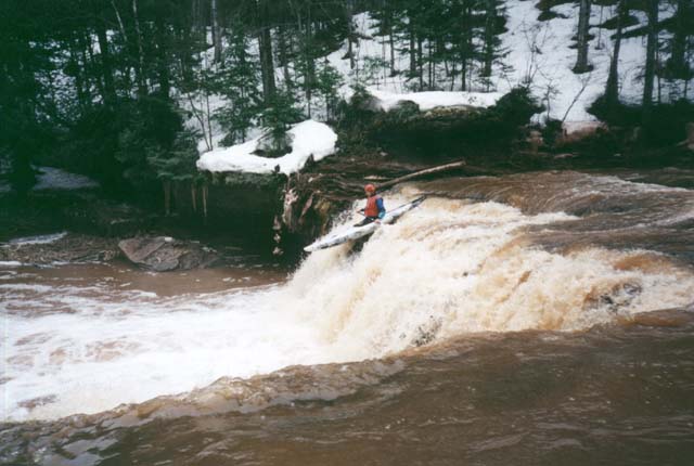
The first 2.5 miles of this reach are a quietwater access paddle with very little gradient. Things start picking up as one approaches ' Creamy Peanut Butter Falls', a very runnable vertical drop of about 10'. A short distance downstream, Okundekun Falls, about 20' vertical which, while possibly runnable, should be considered a portage (river left) since it mostly lands hard on rock. The fun part of the Baltimore begins below Okundekun Falls with very interesting geology creating a great mix of slides and boulder drops (see rapids details below). Unlike most other challenging runs in the U.P., the river bottom is smooth sandstone. (This is the midwest version of slick-rock. In fact, the canyon section downstream makes for some great mountain biking in the summer.) The paddle out on the M.Br.Ontonagon adds 3.9 miles of low gradient paddling (~13 FPM) to this run, and consists of moving water interspersed with a few light rockbed rapids.
Before you change out of your paddling gear, be sure to have a look at Sandstone Creek about 1/2 mile south of the take out, roadside along HWY 45. If you find it boatable, it will be a great 'capper' to your day!

You'll have a nearly 2.5 mile access paddle before the first real drop. There may be a few areas of minor swifts (riffles and rips), but mostly this will be flatwater. And . . . if you are curious what might exist upstream of our listed put-in . . . miles and miles of pretty much the same -- flatwater, riffles, and riffs, maybe a few very brief low-grade rapids (mostly just waves), and likely many many portages (or deadfall-dodging-and-ducking). There is evidence this may be canoed, but it is hard to recommend as a whitewater trip. And the same may be said of various tributaries.
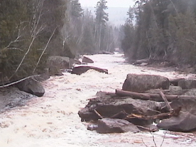
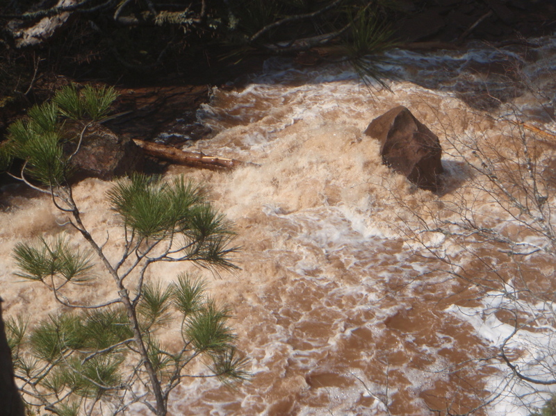
You will also no doubt notice (most occasions this is boatable) that the water is very muddy/silty. This is due to (1) considerable logging upstream, and (2) mostly loose soils, not the rocky stuff of, say, rivers around L'Anse area.
You'd have to ask one of the old-guard 'Hoofers' (UW-Madison outing club) about the origin of the name. (My bet is the answer might involve the color of these muddy waters bearing striking resemblance to that substance.)
This is a short, sweet ledge/falls.
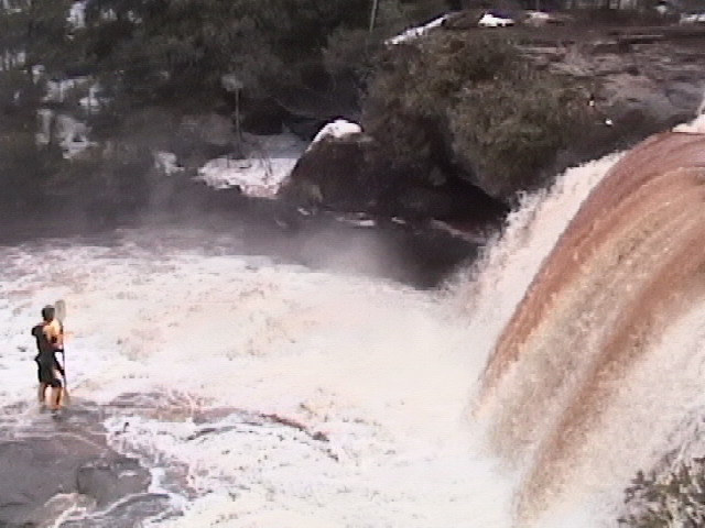
Possibly runnable, but mostly lands hard on shallow rock. Recommended portage.
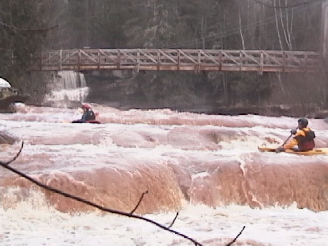
The nearby Michigan community of Mass provides inspiration for names of many of the rapids on this run. ' Let us Pray' is a boulder-garden which begins directly below a footbridge immediately downstream of Okundekun falls.
There are a number of class II and III rapids on the way to ' Cyclops'. The river splits around a rocky island and gradient increases. As you head near the end of the main island, the river drops about 12' in a short, steep slide on each side of the island. Good gradient (class II) continues downstream.
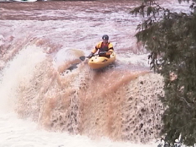
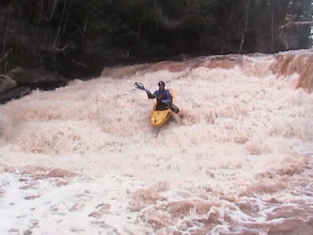
The river continues its slick-rock class II-III rapids until you take a sharp jig/jog and see remains of a defunct swinging footbridge. Take out river right at the footbridge foundations for a mandatory scout. The canyon below is an awesome spectacle. This is the most challenging section of the river, class IV+ at lower flows pushing into class V when higher. Boulders and shorelines are undercut! (Generally undercuts are scarce in the Midwest, but abound on this stretch.) It starts with low angle slide sequences, gradually steepening as the rapids continues. The crux comes with a medium angle slide of about 15' just above where the river makes a hard turn right. The river is deflected hard right with an inconvenient boulder on the outside of the bend, then drops off another, slightly steeper slide of about 12' ( ' The Mass Has Ended'). Scout this whole drop for wood in crux locations before thinking about boating it.
The fun is far from over. Below the major drop lies a 200 yard section of sloping sandstone bedrockin a canyon, for a long, squirrelly, low angle slide ( ' Go In Peace'). There are boulders scattered at random on the surface of this bedrock making a bit of a slalom course. Wood is likely to be trapped between boulders, so plan your route carefully here. Be sure to bring your bike back here in the summer for an excellent ride. Gradient gradually slackens downstream until the confluence with the M.Br.Ontonagon is reached.
Maps show a road of some sort heading near the river. We have no present awareness whether this road is gated, private, or if it can be used as an alternate take-out to eliminate the long (mostly flat-but-flowing) paddle out for this run.
The East Branch has a fine (rather tamer) run.
Apr 17, 2009
George Kaider
This is a really cool run that is an all-day experience in a very remote wide open canyon. The riverbed is very different creating unique rapids, strange side-curling waves, and low head dam type of ledges. It is worth your time and will be a memorable day. We had to walk two stretches due to high water lines that made it very tough whitewater. I think we wimped out on the first section we walked, but the canyon proper section turned into true class V+ after making a dogleg right turn. There were also some death logs crossing the river in here too, so its just the whitewater that is worrisome.
Apr 20, 2008
This dangerous log stuck on the undercut boulder is on the outside of the bend in the beginning of the canyon. Most of the water is pushing into it. Be sure to get out and scout this before you run the canyon. The third footbridge on the run is at the beginning of the canyon (but it and the second one look so dilapidated either one could be removed any time) and is the place to stop and scout from the river right shore.