Cedar Creek
*2025.09.09 Wood Update* Cedarburg Mill to CTH.T (2.3 miles)

| Difficulty | II-III |
| Length | 2.3 mi |
| Avg Gradient | 20 fpm |
| Gauge | Cedar Creek Near Cedarburg, Wi |
| Flow Rate as of 50 minutes | 14 cfsbelow recommended |
| Reach Info Last Updated | September 9, 2025 |
Quick Facts
Location: Downtown Cedarburg to east edge of town.
Put-in: Rebellion Brewing, Cedarburg, WI (street parking)
Take-out: 4900 Lakefield Road, Cedarburg, WI (street parking just west of bridge
Shuttle Length: 0.8 mile, 2 minutes by car, 5 minutes by bike, or walk it in ~17 minutes!
Video Link: https://youtu.be/fMx9dsjahQc?t=154 (link is cued to the putin on Cedar Creek. The Milwaukee-Grafton run is also on the video, which you can watch if you recue to beginning.)
Put-in is approximately 780' elevation, Take-out is approximately 705' elevation, thus total elevation change is approximately 75'. For the 2.2 mile run, that would work out to 34 FPM. Unfortunately, approximately 30' of this is wasted, being backed up by the two dams. This diminishes the effective/usable gradient closer to just 20 FPM.
Class/rating is NEVER enough to decide if you should run a river/rapids! Far more important than gradient and class/rating should be other less-quantifiable 'character factors': continuous versus pool/drop, wide-open routes versus constricted technical rapids, wide-channel (with multiple routes) versus narrow channel (with essentially one route), gradual river banks versus rocky shores or steep-walled gorges, et cetera.
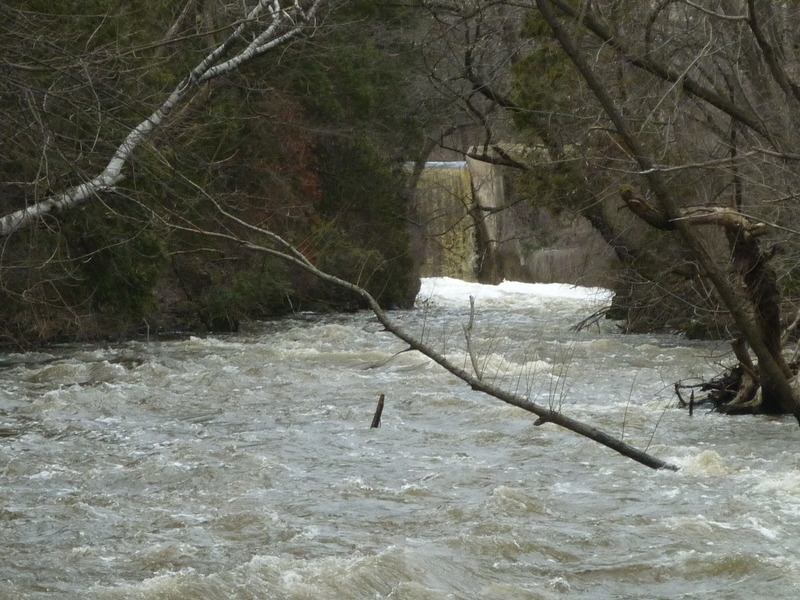
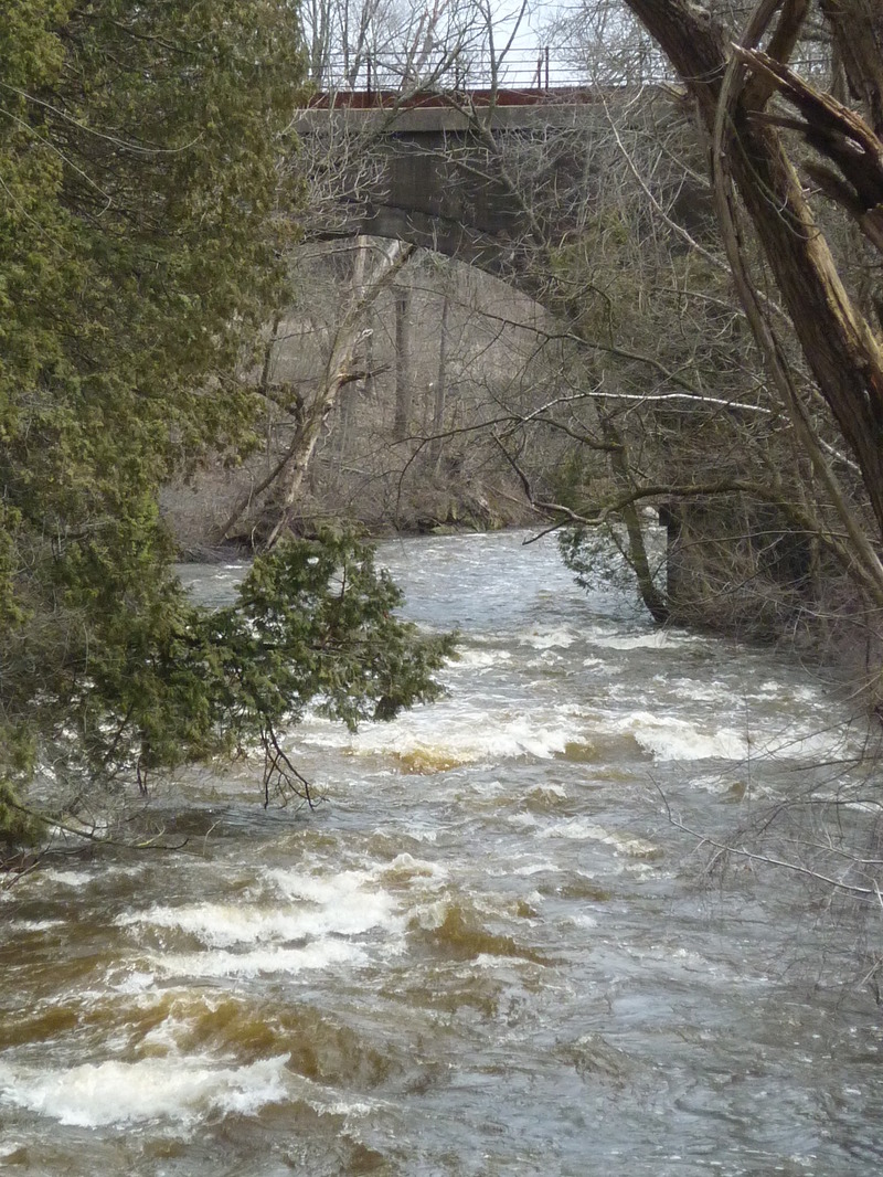
Character: An oxbow in the creek allows paddling 2.3 miles with only a 0.8 mile shuttle! Bedrock ledges and low-angle slides provide a decent assortment of play before gradient peters out in rubble-field shoals.
River banks: (exclusive of the aforementioned mill ponds) vertical walled mini-gorges, steep rocky banks, leading to eroded/vertical/undercut mud banks. Plenty of trees and shrubs (with attendant deadfall, sweepers, strainers, and snags)
Typical widt
...
The USGS gauge is about two miles upstream of the listed put-in, but there are no significant tributaries between it and our put-in. A pair of dams intervene, but they have virtually no 'regulation' or effect on the flow. As a result, the listed gauge VERY ACCURATELY reflects flow in this section.
This creek had long been a 'hotspot' for PCBs (Polychlorinated biphenyls). A major contributor to the PCB load was in the dam pond just above the put-in of this reach. Remediation efforts were done on 'Ruck Pond' (just above the listed put-in) during 1994-1995, on 'Hamilton Pond' (about a mile downstream of our recommended take-out) during 2000-2001, and what is likely the final remediation took place in 2017 in both the the Columbia Pond and the Nail Factory Pond (the two 'ponds' backed up by the two dams normally portaged when doing this run).
As a result, there should now be very little concern regarding PCB levels anywhere on this run.
Headwaters of Cedar Creek are Big Cedar Lake and Little Cedar Lake (in Washington County, just north of Slinger, just southwest of West Bend). Most of its upstream drainage is farmlands and marshes and bogs. As a result, it tends to take somewhat longer to rise and is rather slower to fall-off than many other area runs.
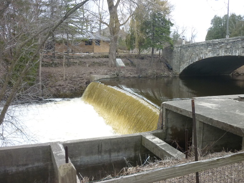
This dam (the first of four within Cedarburg on Cedar Creek) has been identified as having unacceptable risk for failure in flood conditions, which could produce catastrophic consequences in downtown Cedarburg. For this reason, discussions are being held (2025) regarding renovation or removal.
As is often the case, there are two very vocal factions. Those wishing to keep/renovate the dam claim all the dams are important to the history of the town and city and feel the need to preserve that part of their history. Those pushing for removal counter that the dam which actually powered the mill no longer exists. The current dam was built decades after the mill ceased operation, and was built solely to create a pond for swimming and ice skating, thus does not qualify as a 'historic' structure.
We'll have to see how that all plays out, and how long it takes before any decision is reached and action (removal or renovation) actually takes place.
This dam (the second of four within Cedarburg on Cedar Creek) has much less risk for failure and less catastrophic consequences. However, with the prior dam raising the discussion, advocates for removal are reaching beyond the first dam to try to include this dam in the discussion. However, while the city of Cedarburg owns the first dam, this second dam is owned by the Cedarburg Landmark Preservation Society, which is 'committed to preserving it as a part of Cedarburg's heritage', which means that its fate cannot be decided by the city common council.
(This dam is visible in the background of the photo in the masthead.)
Park street side and carry upstream behind Landmark Feed Seed & Supply (the historic Cedarburg Mill), adjacent to the patio for Rebellion Brewing.
About at the doors of the brewpub, a tree stump is very near water level. (Covered/unavailable somewhere above 600-700 cfs.) Carefully lower boat and self down the rockwork to mount up and launch. Another tree stump 20-30' downstream is a bit higher upslope, allowing put-in at higher flows. Other options exist, but tend to be downstream of the 'warm up' features, and mostly involve setting your boat at sidewalk level to get in and slide down stones nearer the main drop.
Peel-out to a few small ledge/waves for minor warm-up (surfs, spins, and attainments) before to the main ledge/drop, which you've likely scouted before putting in (to take note of your 'markers' upstream as you pick from multiple routes).
BTW, some folks may eye the dam upstream (I've heard one claim of having run it 'accidentally', though that's hard to imagine). We strongly recommend against running it. The landing is generally shallow, making boat damage and injury likely, unless you are very skilled at nailing a boof or unless you have plumbed the base of the drop (going at minimal flows to walk/swim the base of the dam).
Width: 60'-70' Length: 50'-200'
A set of ledges (~3-4' total drop) provide an exciting start to the run. Minor play is possible at some flows, but always limited by shallowness and vertical stone walls constricting the stream.
Two main routes are obvious (left-side and right-side), but with imagination and skill there are a number of variations!
Stone/cement steps lead to the water just downstream. Short boats easily fit parallel to the steps for exit; Longer boats will be slightly problematic. Take out, carry up, and relaunch to try multiple runs here (often to the amusement of folks in the park).
***Click 'Show Full Descripiton' to read about concerns here!***
Portage: 100', awkward steep slope egress, steep rock chute return to creek.
An attractive rock-arch bridge at Highland Drive signals the end of the millpond. Before the bridge, a small park river-right looks inviting to get out and walk a path up to the sidewalk. Across the street, river-right is a residential property and river-left is now a medical building. To carry into either property from the sidewalk is a trespass unless (before you put on) you have secured permission to do so!
Wisconsin law requires an available portage around a dam which must be marked with signage (which is absent here)! You have a legal right to portage as long as you enter the private property directly from the river (creek), spend as little time on shore as possible, and take the shortest distance to return safely to the stream. Be very careful to 'leave no trace' of your passing, doing your best not to disturb anything on shore, leaving all landscape (rocks and plantings) as intact as possible.
RIVER-RIGHT: Paddle as tight to the right shore as possible as you come out from under the bridge. Beach your boat parallel to the shore (taking advantage of a bit of cement and rockwork in the water immediately below the bridge). Exit your boat, carefully carry upslope, across a short bit of back yard, and find one of two mini-ravines in the steep, ~12' limestone riverbanks. Small, precarious handholds and footholds generally allow a careful climb down to water's edge, though most often you'll find a significant accumulation of plant matter (pine needles and leaves) making footing quite tenuous.
At water level, a large tree stands on the banks. At low-to-moderate flows, a fairly flat, mossy/gravelly patch of land allows easy re-entry to your boat. At higher flows, you will have to do your best to stabilize your boat in the shallow eddy to get in. At higher flows, more advanced paddlers have been known to forego scaling down the wall, instead doing a 'seal launch' from lawn atop the riverbanks! Nail that boof if you try this!
RIVER-LEFT: There used to be viable portage on this side. However, a gated and locked iron fence now stands at the top of the steps (downstream river-left of the bridge). A building (storm drainage system related) now occupies part of this corner of the lot. The capstone 'patio' area spanning the millrace (which formerly allowed dropping down to land and water access) is fenced off. A storm drain outfall with steep loose quarried-rock rubble (which will tip and slide underfoot if you were to try to scramble down it) has been constructed. With lack of use, shrubbery increasingly blocks access to the formerly accessible shoreline.
WE CANNOT RECOMMEND ANY ATTEMPT TO PORTAGE ON RIVER-LEFT!
**NOTES (as of June, 2022)**
Part of the rock wall forming the sidewalk guardrail of the bridge collapsed into the creek. This rocky debris actually makes beaching a boat (at river-right) and exiting the creek a bit easier at flows under 600 cfs! (That rocky debris may catch and hold leaves, twigs, branches and other debris from time to time.)
Returning to water level after your river-right portage, there is a good-sized log (branchless tree) parallel to shore which may slightly hamper paddling out into the current at some flows.
NOTE: This dam is owned by the city (like the 1st dam, at the Woolen Mill). It has been repaired/renovated relatively recently. The millrace has a working release gate which will be used at times of high flows. There are plenty of properties on the pond above (with strong feelings to preserve the 'pond'), and the 'dells' downstream can easily contain flooding flows without risk to adjacent properties. As a result, this dam is not under consideration for removal.
An alternate put-in (skipping the city park ledges, the flatwater paddle of the pond, and the need to portage the first dam) is available at a city-owned park which is accessible from a cul-de-sac on Creek View Court, Cedarburg. (Mapping/routing should work with just that info, or use coordinates 43.2999, -87.9739) On GIS/plat maps, this greenspace is named 'Hoffmann Glen Park' (though I see no on-site signage to that effect, and Google maps and other apps do not recognize that name).
Park in the cul-de-sac adjacent to the path (don't block the path). Follow the path (initially pavement, quickly turning to rocks, dirt, and tree roots -- watch your footing!) about halfway down the slope, looking for minor path off to the left to get to the creek at a fenceline between conservancy property and the private property. Slackwater/eddy should allow peel-out into the current above the Bank Waves.
For PnP (park-and-play) of this feature (not doing any distance of the run), or for carry up to re-run the upper Bank Waves, look for low shoreline river-right (at the inside of the bend) immediately downstream of the outflow from these waves. (Not very far downstream, the right bank becomes a vertical wall of rock, not affording any convenient egress until you are nearly to the Nail Factory Dam.) Carry upstream on the conservancy path to either rerun the rapids or to return to your vehicle (to just do a park-and-play of these waves).
NOTE: According to the GIS/plat for Cedarburg, the park officially extends just down to the Narrows. Right about at that point on shore, you will feel like you are in the back yards of the next seven houses. However, the GIS/plat shows those properties all ending very close behind those buildings, and the remaining distance to the creek (between the Narrows and the dam) is shown as 'Environmental Corridor', so as long as you are respectful of those properties, you should be able to pass without trespass!
Width: 30'-50' Length: 100'-200'
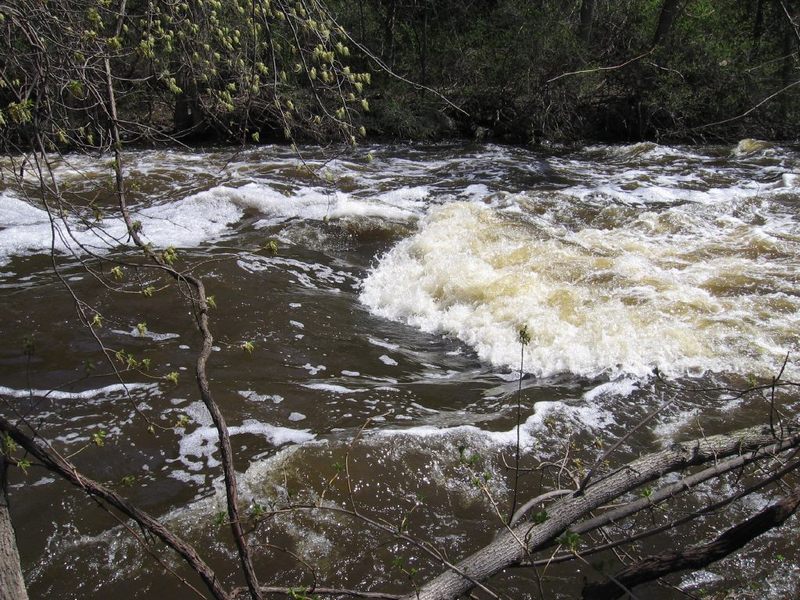
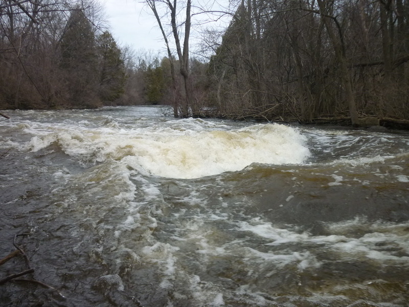
Sloping bedrock create surfable waves: the first two are often catch-on-the-fly, while the wider bottom wave has a river-left eddy for repeat play.
Tame play is possible from 250-500 cfs. The bottom wave builds quite nicely from 500-1600+ cfs, providing wonderful surfs.
At high flows, outflow heads into a steep sometimes brushy river-left shore as the creek bends to the right. (Good paddlers, upright in their boats, should be easily able to stay clear of danger. Weaker paddlers, or anyone upside down or out of their boat may be at great peril of entangling with this shoreline and any woody debris.)
A large river-right eddy exists, but you cannot access the final wave from it ... you would need to ferry across to the river-left eddy.
At flows 1800-2000 cfs and higher, Bank Waves (and nearly all other playable waves) tend to wash out. The whole run will be a risky freight-train of a ride. (If this creek is flowing that high, there are better, safer things to paddle in the area.)
==============================================
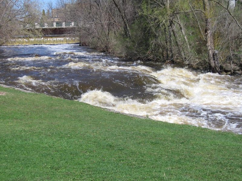
The state DNR issued an edict that all dams (of a certain size/class) must be able to pass the 0.2% chance flood (most often totally wrongly labeled 500 years flood'). The city has renovated the gates in the millrace, and operates them whenever flows are elevated. Water in the millrace returns into the pool below the bottom wave, raising the pool, and diminishing mainstream flow, washing out the bottom wave. As a result, what had been one of the two best playspots on this run, is now often absent.
NOTE: Back when these features were named, the buildings at river-left were the Cedarburg State Bank. Some years back, that became part of BMO Bank. That recently closed, and it now appears this is a medical clinic. At least for the present, we will keep the name in honor of the many years when the building housed banks.
Portage: <200', easy carry, but steep rocky chute to return to river.
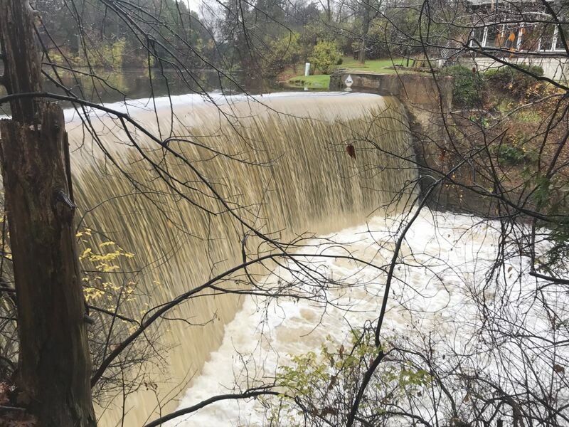
NOTE: the on-shore 'Environmental Corridor' ends right at the dam. The private property upslope (downstream of the dam) actually extends all the way to the creek (and, in fact, extends across to the other shore once past the realty office downstream of the Nail Factory property)! Wisconsin law specifies we do have the right to portage a dam (and further specifies that the portage must be marked, which this one isn't!), but implicit in that right is to be as respectful of the private property that you are on, practice 'leave no trace' ethics, and do not dally!
While the dam has been run (I believe nearly always at lower water levels, around 300 cfs, +/-), most boaters will opt to portage, river-right. Pause to have a look at the dam (and it's boil line!), then carry downstream to carefully make your way down a steep bank to get back on stream.
Those with mountain-goat abilities may be able to carefully shoulder/carry boats downslope to the river. Otherwise it may be best to have one person carefully get partway downslope, have the person at the top pass boats down one at a time, so the midslope person can lower them to a stable position next to the creek. Or ... if you have a throw-rope and a carabiner, affix it to your boat to lower it down, then make your way down (using your own skills or the rope, looped around a tree up top).
FOR SAFETY OF ALL IN YOUR GROUP: No one should begin the climb down while someone else is still making their way down! If the upper person were to lose footing and slide down, they would wipe-out the prior paddler downslope, increasing the likelihood of injury to both people.
At moderate-to-high flows, finding a convenient place to re-launch can be a challenge.
For anyone considering running the dam, be aware that the right bank angles in considerably, so you want to be at least 10-15' off the right flank of the dam to avoid a hard piton landing. Rescue would be difficult here since it is not easy for anyone to get near the river at the base of the dam. Anyone caught in the boil-line (at higher flows) would be in serious trouble. A very shallow boulder-field backs up the pool, and sometimes catches wood and debris.
Putting in as far upstream as possible (at the base of the climb down) will allow strong confident paddlers a chance to make a ferry across strong currents to catch an eddy behind a cement wall (at least, at flows up to 400-500 cfs ... above that, water overtops the wall and increasingly washes through the eddy). From this river-left eddy, it can be very interesting to paddle through one of two archways to go under the Nail Factory building and look at the huge timbers which support it, as well as seeing the base of the turbine which turned shafts and gears to power the whole operation. (BTW, technically there's a fine line as to whether this is trespassing. My belief is that as long as you are on the water, you're good ... just don't go ashore under there!)
NOTE: This dam is privately owned by the owner of the house at river-left. The owner is a local (Mke) developer who (according to rumors, anyway) has sworn as long as he owns the property, the dam is not going anywhere. Also, when the properties on river-right upstream of the dam were developed, (again, according to rumors) they were given assurance the dam would remain in place (though none of those properties extend as far as the river banks, thus have no direct stake in the dam).
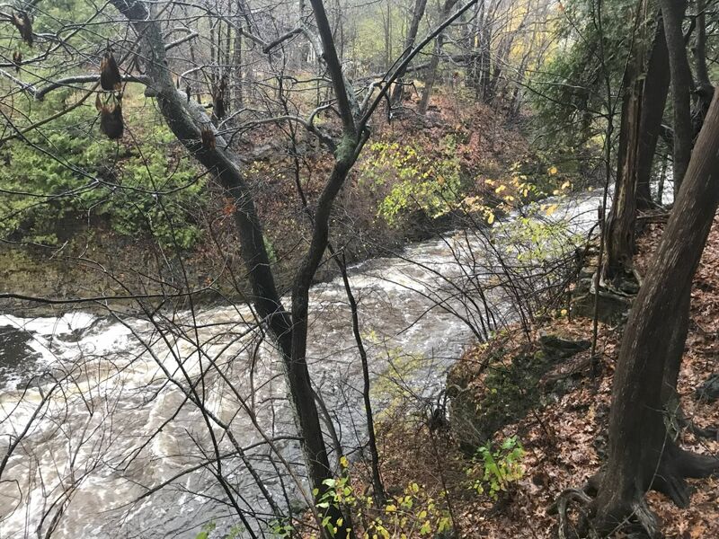
The outflow from Nail Factory Dam heads toward the river-left vertical rock wall in the lower dells. At good flows, water hitting this wall forms a little dish of a wave which can be surfed, and (diving the nose of your boat into the trough) allows fine enders (if you have the skill and interest to do so when you are 'Up Against the Wall'). A slackwater eddy at river-right allows repeat play, if so inclined, before continuing downstream.
Swift currents lead through a brief vertical walled dells before the banks widen and flatten out a bit.
NOTE: One can't help but think that if the Nail Factory dam were not present, this dells would extend 0.3 mile upstream (adding the entire length of the millpond from just downstream of the Bank Waves) with over 18' of drop, with who knows what assortment of ledges and rapids!
As the dells walls recede, before the Estate Bridge is visible downstream, a couple minor waves occur (at least, at some flows). These allow some smooth easy surfs.
NOTE: For 2023, trees/branches at river-right allow passage without much problem, but these waves are gernerally not well-formed until such time as this clutter blows out.
Width: 40'-60' Length: 200'-350'
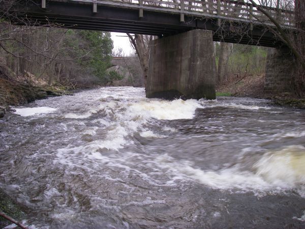
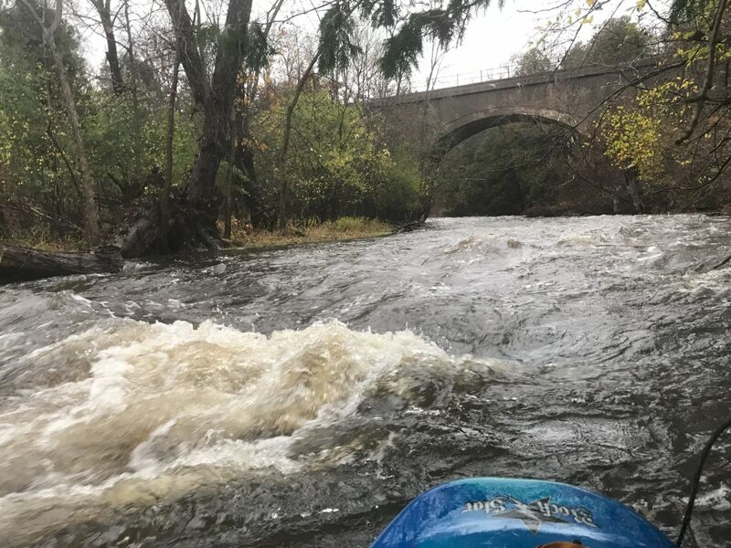
Increasing gradient leads around a curve toward a bridge-pier which constricts the flow. A wave forms just upstream center of flow. Boaters with solid boat-handling skills will charge into a river-left eddy under the bridge for repeat play. Minor play is available as low as 100 cfs (though all else will be extremely boney). Sweet surfs are available on a powerful fast wave from 600-1600+ cfs. It never develops much of a foam-pile, thus is not retentive for linking vertical or aerial moves.
FWIW: the property accessed by this bridge used to be one private estate. That property was divided into four lots, three newer homes were built, and the four properties comprise what is apparently called 'Ravine Manor Condominiums'. Two of those four properties extend across the creek to include the frontage along Columbia Road/Wisconsin Avenue. This is being detailed here to emphasize that all land flanking this run downstream from the Nail Factory dam is privately held, and setting foot on dry land is technically trespassing.
NOTE: AS OF 2024.03.26, all trees (formerly in the water immediately upstream and down of Estate Bridge) have been cleared! One tree/sapling arches over nearly half the width of the approach to Estate Bridge, so it is still a good idea to scout before or during shuttle (in case things have changed) or (failing that) to at least eddy-out river-left before running Estate Bridge, just to know that it is still clear before running. (If you come around the blind curve heading into the bridge without scouting, there are only micro-eddies and awkward egress if you would need to avoid any new deadfall!)
Width: 60'-80' Length: 100'=200'
A couple of small ledges create a couple of waves at most flows. Minor surfing is possible.
NOTE: Large woody debris lies a few locations (mostly at the left) between Estate Bridge and the Railroad Bridge. Generally these do not hamper passage, but are likley changing flow across these ledges, altering playability here (which is seldom all that good anyway).
Width: 45' Length: 50'
Just beyond the railroad, look for a bit of rocky outcropping on the left shore, where a few rocks and bedrock in the creek make (at some flows) a small, sometimes surfable wave tight to river-left. This is pretty much the 'last hurrah' -- the final whitewater feature. From here down, the creek is pretty much just splishy-splash shoals and swiftwater. Do not let down your guard, however, as there will still be some technical maneuvering needed to safely negotiate narrow twists and blind turns, as well as deadfall and overhanging trees and branches.
A bridge (connecting properties on each side of the creek, owned by the Hazelwood estate) spans the river. At low flows there will be shallow shoals through this area. At some flow (above 'maximum recommended flow') this bridge may become a hazard (too low to the water). The bridge pier/support left-of-center can catch whole trees and other woody debris. More than once, it has 'collected' canoes and recreational kayaks, folded in half around its leading edge.
FWIW, between here and the island downstream, Cedar Creek is within 1/3 mile of the Milwaukee River in Grafton Dells, just downstream of the canoe launch in Grafton Lime Kiln Park. However, the creek meanders another 3.3 miles before its confluence with the Milwaukee River, downstream of CTH.C.
WARNING: As of summer, 2022: An assortment of trees and large branches have broken off and hang over and into the water various locations downstream of this private bridge and upstream of the large island. All have been passable (so far), but require alertness and some maneuvering. It is possible some of these could drop into less benign positions or accumulate other debris, thus making passage more problematic at some time in the future.
A large island (13.2 acres ... owned by the aforementioned Hazelwood estate) splits the flow.
Left of the island used to be the main channel (as shown by the default software's mapping of the river). However, over the years, it has become totally blocked by woody debris (at the entrance and places downstream), so you must head to the right of the island.
The right channel is shorter, but the entrance is a sharp zig-zag (right, then left, then right again), sending strong current into the shores, undercutting the streambank. Point your bow toward the left streambank and paddle hard to avoid being pushed into the undercut bank!
Since of April of 2023, hidden just around the first bend, trees and branches block nearly 2/3rds the width of the stream. Safe passage will require skillful paddling. Keep to the river-left ('inside of the bend') as you round the tight-left bend! From that eddy you should be able to avoid disaster of being swept sideways into the branches!
Immediately downstream, additional twists, turns and overhanging trees will keep you scrambling. Keep using the above technique (point bow to the inside around bends and paddle strongly) to avoid disaster!
As you near the end of the island, there is a large tree in the channel. As of May, 2025, either the tree has moved (slightly more parallel to the flow), or shoreline to the right has eroded a bit, (or a combination of the two), making passage easier than it had been for the past few years.
In the 'flow shadow' of a private island (formerly with foot-bridge from private yard), there is generally sufficient depth and some fairly interesting currents (at higher water levels) to allow some playing with stern-squirts and bow-stalls. (Not saying it's a great squirt spot, but with slicey boats coming back into vogue, it's one of few deeper spots with currents on this run.)
While one could proceed downstream, the gradient has largely petered-out at this point. And, it's tough to beat a 2.3 mile run, with only a 0.8 mile shuttle.
For the easist take-out, go just a bit beyond the bridge to where the low grassy shore allows easy egress and easy carry up to roadside.
Paddlers wishing a longer trip may extend their outing by nearly a mile, taking out in the quaint little burg of Hamilton. This yields a trip nearly 3.2 miles in length, with a shuttle of only 1.3 miles.
There will be very little actual whitewater in this extra distance, though there may be swiftwater and shoals. The main 'benefit' will be seeing a bit more of this area. Hamilton has a good number of historic stone buildings (houses and businesses).
However, take-out here is very awkward. River-left is all private property. Above the bridge river-right is very steep banks, uneasy footing, and heavily covered in vegetation (at least, once summer arrives). Downstream of the bridge is private property and a vertical cement wall.
A longer trip might continue to the mouth of Cedar Creek at the confluence with the Milwaukee River. Again, precious little actual whitewater would be found (both on Cedar Creek and on the Milwaukee River), though the current will generally be swift at any recommended paddleable flows.
This confluence lies just 0.43 mile downstream from where the Milwaukee River is crossed by Lakefield Road (CTH.T). Paddling that 0.43 miles upstream on the Milwaukee River would be arduous (especially since just as the bridge comes into sight, you will encounter rocky rips and increase current to paddle against). Brush beating (walking upstream) that distance seems also hard to recommend (all land surrounding the Milwaukee River here is private property).
Thus, paddlers are more likely to paddle 1.32 miles downstream to exit at Pioneer Road (CTH.C), making a total very near 5.9 river miles, and a shuttle of 3.0 miles.
Nov 5, 2022
Apr 15, 2013
Almost immediately downstream of the Estate Bridge (which is pretty much the 'main event' of this run), you'll find a wave-train which leads you down to a couple of ledges (well, really more like transverse dips in the bedrock) which can allow some tame, but sometimes interesting and worthwhile surfs.
Apr 15, 2013
At 710 cfs, this is a sweet, juicy wave. The approach to it (as you come down from portaging the dam) has two catch-on-the-fly waves which can allow surfs and spins, but no repeat play (unless you carry up the heavily wooded shores). This bottom wave allows great repeat play.
Oct 3, 2011
The put-in is right outside Rebellion Brewing (in the backside/basement of the old grain mill). After your run (when they are open) you can enjoy an excellent selection of top notch craft beer. There are outdoor patio tables (during warmer weather) overlooking the river. They don't serve food (other than pretzels or pre-made frozen pizzas), but you can order food from nearby restaurants and have it delivered to you at the pub! Check 'em out: http://rebellionbrewingusa.com/tap-room/