Bobtail Creek
(hike in) FS 1219A to Richland Creek (2.75 miles)

| Difficulty | III-IV+ |
| Length | 2.8 mi |
| Avg Gradient | 120 fpm |
| Gauge | Richland Creek Near Witts Spring, Ar |
| Flow Rate as of 1 hour | 0.69 ftbelow recommended |
| Reach Info Last Updated | February 23, 2018 |
Creek may be significantly different after the March 08 flood.
Note: The combination of Steep banks and lots of deadfalls tend to clog the creek with wood from time to time, so keep look out.
Put-in: Take Richland Creek Road East from Falling Water Creek below the low water bridge toward Hwy 16 at Witts Spring. Turn (North) on Bobtail Trail Road for 3 miles. Park at this point on an 4-WD road that descends a hill to the right (East). If conditions are good or you want an adventure you may be able to drive the 0.7 mile down to the creek on this road, otherwise carry. If you miss this road, go to the end of 1219A and turn around, come back 0.7 miles.
Take-out: Option 1 is to carry along the ATV trail from the confluence with Richland Creek back upstream to the Campground (1-mile). Option 2 is to run the remaining 7.5 miles of Lower Richland. (makes for long shuttle)
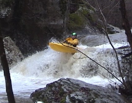
It contains about ten significant rapids and lots of class II-IV action in between. For the first 0.75 miles, the creek is shallow and fast class II-III with willows, a good place to warm up. This section is also prone to downed trees. Be on the lookout for a sweeping bend to the left terminating in a tight slot, the beginning of the good stuff. The 'Opening Act' is a first series of drops from Zorro to just above the Little Bobtail confluence. The drops are back to back and contain fairly tight moves. The action calms for a short while when Little and Short Bobtail creeks enter on the right. But soon this 'Intermission' is over and the 'Feature Presentation' is ready to demand your attention.
Paddlers should be confident running all rapids on upper Richland before trying this run.
Gradient by mile (100, 160, 70 in .7 miles). Steepes
...
Long rapid that consists of 3 sections. It starts with a tight slot-turn back to the left behind a pin rock. Cut back to the right after the slot and back to the left (the Zorro portion), over a small ledge avoid the undercut on the right, and line up for the wave/hole train that follows (The Minotaur portion). Finish by snaking through the rock gardens below with a 4-foot double ledge in the middle. A large boulder rising vertically from the right signifies time to eddy left to scout the next drop.
aka 'Go Left Falls'. Most of the water flows off a flat rock slanted to the right and into a nasty-looking narrow slot and undercut. Get up plenty of speed and go off the end of the flat rock. Several encounters with the slot have produced bruised bodies and egos.
Fall 2006: The crack on river right has opened up to allow more water into the sluice/undercut. This drop is currently a portage unless the water level is high.
(Name is pronouced Cooper for first descent pioneer Cowper Chadbourn)
aka 'Go Right Falls' due to a tree in the left slot on the first runs. Main channel goes to the right and over a 6-foot stairstep ledge. Alternate route is to run the slots on the left and boof into the eddy below the ledge. Take the straight line in the runout through a 3 foot wide slot.
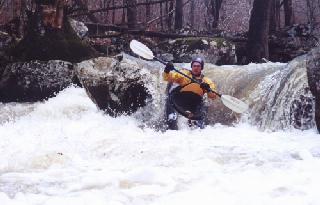
Now the 'Opening Act' of the above drops is over and you get brief intermission of more fast class II-III water as Little Bobtail and Short Bobtail enter from the right to pump up the volume. When the creek cuts back to the left over a horizon line, you're ready for the 'Feature Presentation' of the lower gorge. The next 0.75 miles is Ozark creekin' at its best.
Starts at the next horizon line as the creek bends to the left. This is a long drop with undercuts, trees, holes and pin potential. Main line is to enter down the slide to the right, avoid the rooster tail rock and tree in the middle of the creek, over the ledge, around the corner to the right and down through the series of holes to the left. The holes tend to push hard to the right and into the shallow rocks on the bottom right side. Finish through some tight slots after the recovery eddys below the holes.
As the creek turns back to the left, enter on the slide right and catch the right eddy, ferry back to the left above the Fang rock and down through the series of holes.
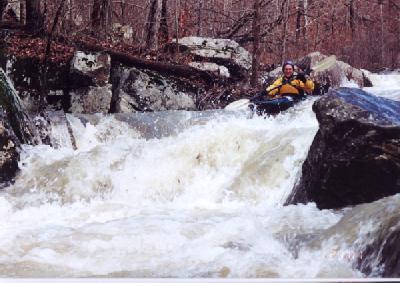
The first ledge is can be sticky, enter from right and punch the angled hole to the left. Turn right for the bottom ledge and angle left to avoid the piton rock. This is the drop pictured above.
After a few more quick turns, your at the entrance to the 'Funnel'. Again trees growing in the middle of the rock garden hide the horizon line. Enter right and punch the sticky ledge hole, and ride the flume down through a couple more holes into the eddy-pool below. The holes in this one have captured many.
Several more class III/IV rock jumbles follow. Including 'Sneaky Pete'. This hidden hole will trash those not on the ball. Be on the look for a rapid where the flume narrows to 10-12 feet and flows into a house sized boulder on the left bank as the creek cuts sharp right. A large eddy to the left is a good place to stop and prepare for 'The Slot'.
The creek curves back to the left and cuts back right as it funnels between two large boulders slanting in from each bank. Build up speed to punch the entrance wave-holes and the final hole at the bottom. This hole has provided numerous creekboat rodeos.
End of Bobtail. Carry 1 mile upstream along Richland via the trail to Richland Campground (take the right forks) or paddle 7.5 miles to the Lower Richland take-out.