Escanaba, M.Br.
B) Co.Rd.CG to 1.2 mile above CR565 (10.8 miles,+1.6 miles for lower)

| Difficulty | II-IV+ |
| Length | 10.4 mi |
| Avg Gradient | 18 fpm |
| Gauge | Escanaba, M.br. Upper |
| Flow Rate as of 1 hour | 160 cfslow runnable |
| Reach Info Last Updated | March 20, 2026 |
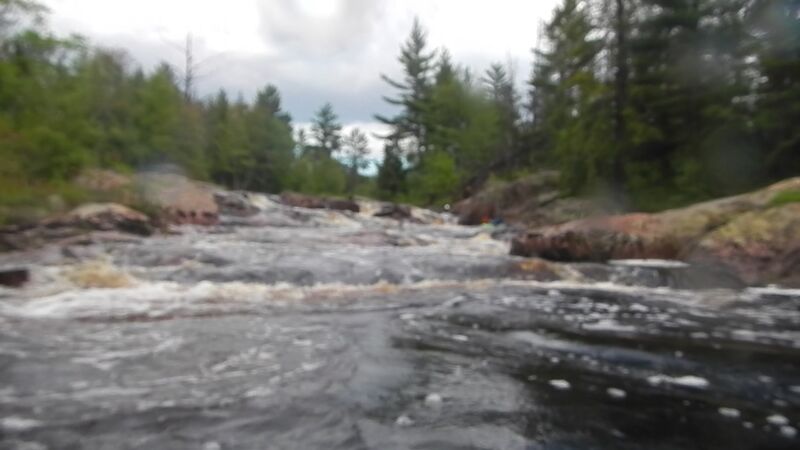
More like 'drop/lake' than 'drop/pool'. (Much flatwater between drops, but the drops are good and the flatwater sections are a beautiful wilderness river.) The first three drops (while not overly complex) can be the most troublesome (i.e., most likely to be portaged, or likely to cause major thrashings). With high water, almost all of the drops on the run will be plenty intense!
Since this is a rather long run, with extended flatwater between drops (one stretch of nearly 3 miles, another nearly 2 miles, and three others over a mile each), feelings about this run tend to divide into two categories. Many boaters will 'pass', or do it once or twice and say 'Never again!' Others will consider the flatwater a reasonable price to pay for the variety and challenge of drops it contains, and will keep it on their list of favorites to hit regularly. This is especially true since this river tends to have a longer season (runs a bit later or more often) than most of the U.P. creeks.
The aerial resolution on mapping apps for this river is quite good. We highly recommended going to the 'Map' tab, clicking on 'Topo' to change it to 'Satellite', clicking the '+'/'-' to (or pinch/zoom in and out), and doing a 'virtual walk' of this reach (using the arrow keys on keyboard, or using the drag/scroll movement on your touchscreen device)! Yes, you will see the long stretches of flatwater, but you will also get a feel for the configuration of most of the drops.
The bulk of this route, especially through the main waterfalls, now goes through posted private property on both sides of the river and falls. Historically, boaters had put-in from a gated, dead-end road (labeled County Road PPE on GoogleMaps, but I'm not sure if you'll find any signage indicating that designation anywhere in real life). It was possible to park in one of a couple of wide spots (which would allow other vehicles to be able to pass). Early/Late-season
...
USGS lists a sampling site with drainage area of 164 square miles at our listed/preferred put-in. You'll have ~1.6 miles of flat/flowing water (no rapids) to the first major drop.
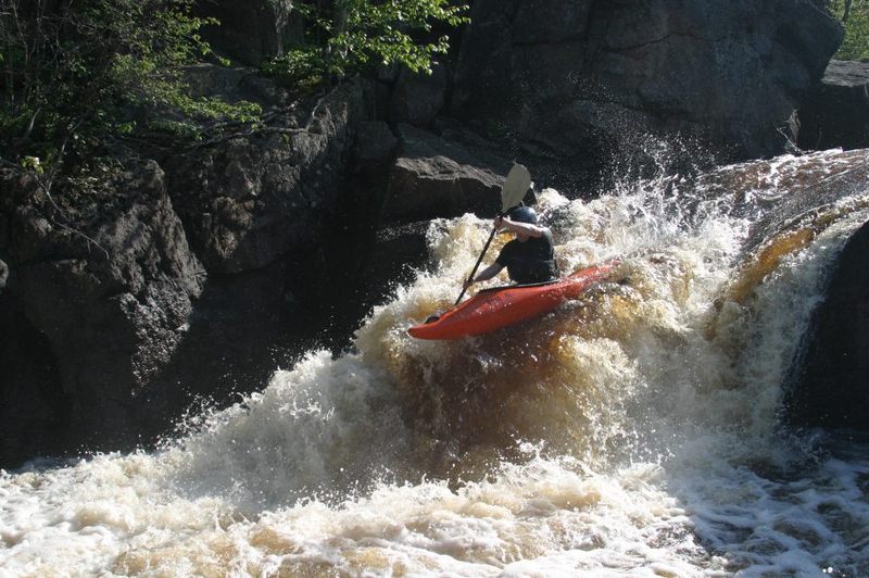
These falls are now surrounded by private property. This falls is just around the corner from the put-in (or 1.6 miles from the Co.Rd.CG put-in). You may encounter very aggressive (non-boater-friendly) landowners taking issue with your presence even when not on river-left. Do not dally any longer than necessary here!
The lead-in is pretty straight-forward. The lip of the falls is seriously 'notched' on river left, up against a wall of rock at left shore. A significant hole and boil will exist at medium-to-high flows. The right wall downstream in the pool is undercut, and the boil is likely to push you strongly in that direction! There is a bit of a 'room-of-doom' in the eddy near the falls, so you probably want to try to angle left off the lip and drive out through the boil and downstream.
These falls are now surrounded by private property. In some ways a bit like a bigger, meaner version of the first falls. There are a few good diagonal waves in the lead-in (to trip you up if you aren't careful). The lip of this falls has a big boulder left-of-center. There may be a (theoretical) line to one side or the other near this boulder, but most runs are more center-to-right, to come off a bit of a tongue of water. The landing seldom seems too 'keepy', but again, there is an undercut wall downstream right.
As the river encounters an island, the left channel spills across a couple of ledges. They are generally quite straight-forward, and could offer some play (other than generally we have never been in a 'play' mode on this long run). (My first run on this, we encountered an inner-tube on a very extended surf in this ledge/hole!)
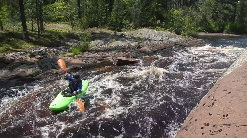
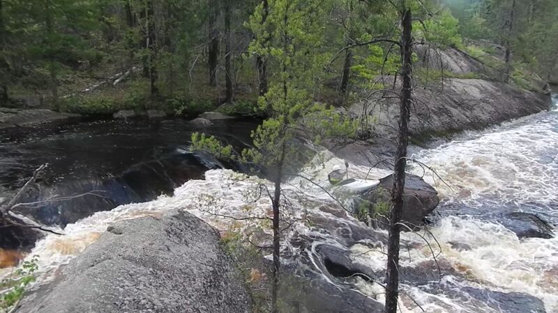
Private property along both sides of this entire stretch. A 'guard rock' or 'guard ledge' confuses the entrance to a half-dome hump of rock. The recommended line (usually) appears to be attempting to ride the top of the hump (to avoid the aggressive holes left and right), but that is more easily said than done.
A brief pool separates this drop from the preceding drop (Half Dome). A line of rocks splits the flow into a number of pourovers. More rock downstream left tends to funnel more of the flow to river-right, through a short series of waves and holes, before it smooths out to a swift runout into a good pool.
After this feature, there is nearly three miles of flatwater (punctuated only by a few very minor riffles or rips) until the next significant features.
After a long (2.9 miles) flat stretch with only one minor rapids interrupting, you finally get to a significant narrowing of the river. A (sometimes) quite juicy pourover/ledge lies in the narrows. Flow heads toward a large rock island, and is diverted to the right, into a large pool. Out of the pool, the flow trips across numerous waves and holes, some of which can be pretty sweet looking. Play may be possible on a few of them, though (again) we've typically been more intent on continuing downriver on this long run.
This is followed by very nearly a full mile of flatwater, again with only minor rips interrupting.
A few different routes are available/viable here, so some may opt to carry up to try more than one. To extreme river-left, a small pourover drops into a 'sluice' between shore and a line of rock parallel to it. To extreme right, a wider channel (or sluice) leads to an often grungy exit. Partway down this route, one can veer left to head to center stream. Down the middle there is generally considerable less flow (obviously at low-to-moderate flows for the river). Overall, generally not too difficult, but you can find/make some more technical or interesting lines. The runout often has a small surfable wave. Scouting is advised (particularly for river-right lines) as this area has been known to accumulate jumble piles of wood (hence the rapids name).
Following this you'll encounter the second longest flatwater stretch, with ~1.8 miles to the next significant feature.
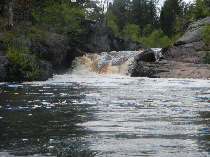
After nearly 1.8 miles of flatwater, some minor boulderbed rapids are encountered. The river takes a right-angle bend (to the right) and a horizon line awaits. This is a sweet sliding drop, into what can be a rather sticky hole (at some flows). Generally best just right down the center, but occasionally boaters may try a line more to the left, to avoid the 'meat' of the hole, and drop a little bit of a 'boof' which can exist off the end of the slide to that side.
The hole can (at times) look really sweet for play, however, the right side of the outflow pool has much rock, generally fairly smooth but also generally fairly shallow, which will hamper access and generally inhibit most interest in risking much play. A LARGE pool (almost a lake!) follows, before the river twists left to continue.
(Note: Rating this rapids is a bit tricky. It is such a simple smooth slide (with no complexity to the approach, and a huge pool below) that it could be called barely class II. However, good boaters have gotten 'worked' by the hole at the base of the slide, which would suggest that it can deserve the class III or higher rating. YMMV.)
Following this, you'll have ~1.2 miles of mostly flatwater to the next significant feature.
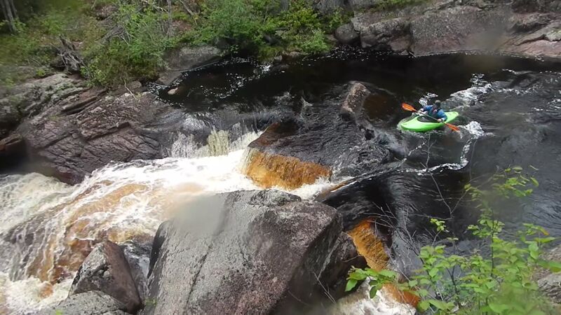
Just beyond a good jig-jog right and then left, the final rapids/falls of the 'upper' reach is encountered. A short pourover/wave/hole traverses center-to-right, causing boiling swirly water preceding the main action here. A huge rock lies just left-of-center below. Water flowing between the sloping bedrock of the left shore and this 'middle finger' tends to funnel into a really aerated boil below. Best outflow is tight to the left wall, since a ledge of shallow rock lies immediately behind the 'middle finger'. To the right of the 'middle finger', flow drops across a couple smaller ledges/rocks (possible hole or two) before meeting the pool below. Often the sweet/semi-gutsy line (to avoid the potentially tricky boiling pourover at the top of this drop) is to start at river-left shore above the drop, drive powerfully toward the right, on smooth flow (which heads toward the 'middle finger' and drops down the left line), keeping your boat upstream of the rock, to drive into the right channel as previously described.
From this feature, it is just over a mile to our listed take-out, or (if continuing with the lower section) about 1.4 miles to the next interesting feature.
Aug 30, 2024
Explored this area in late summer 24 after moving to a camp upstream by Greenwood Res, and all of the land on both sides of the river in this stretch are now posted private property. Do not approach White City Falls (or the downstream Second Falls, Islands, Half Dome, or Granite) if you're not sure you'll make it through the falls without leaving the water. Owners on river-left of the main falls were less than welcoming.
May 11, 2018
This seemed to be a pretty good level. The first 3 features (IV) were a bit pushy, but the rest of the river, except Middle Finger, was a bit boney. White City Falls was a class IV at this level. River left was a boiling hole and there was a recirculating eddy on river right. You needed to boof the center and land with a left angle then paddle. Second City had an entrance whole that made it more challenging. Granite Canyon needed a good scout. We walked Middle Finger, there just didn't seem to be a way thru it staying right side up. Half the river was hitting the finger and turning 90 degrees left. Right of the finger the water seemed to be piled up in a pool like it was behind a dam and below the dam was a hole. And we were tired and it was a 30' portage. The 'sweet/semi-gutsy line' described in the Middle Finger description was discussed, but there seemed little room for error.