Potato
C) Hwy.169 to Potato River Rd (6.5 miles)
| Difficulty | II-IV(V) |
| Length | 6.6 mi |
| Avg Gradient | 49 fpm |
| Gauge | Potato@hwy.169 |
| Flow Rate as of 54 minutes | 14 cfsbelow recommended |
| Reach Info Last Updated | September 7, 2020 |
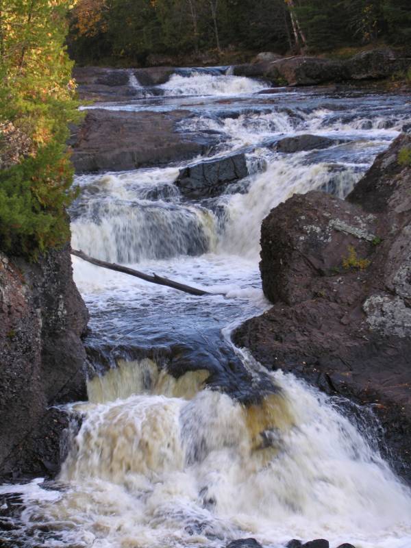
While sections of the Potato River Falls sequence are runnable, most landings are very shallow. (Average and Maximum gradient figures are skewed by the falls sequence, at least the final drop of which virtually all paddlers will not be paddling.)
A bit more than a mile downstream of the falls, as you cross into Ashland County, you are in the Bad River Indian Reservation. Permission from the Bad River Tribe must be obtained before paddling if you wish to continue your trip into the Reservation. (We are uncertain how likely they are to grant such permission.) For this reason, it is likely most paddlers will end their trip by carrying back to the Potato River Falls parking area (from wherever short of the county line they decide to end their trip.
From YouTube, here's a video showing a great aerial view of Potato River Falls: https://youtu.be/Lvyxz7-\_JCM

USGS gauge at our listed put-in lists drainage area of 91.46 square miles, and was activated on 2024.06.20, so we don't have much history to work with. FWIW, on July 5th, the gauge hit a max (for the part of the year it existed) of 292 cfs.
It appears (from aerial views) things may get a bit more complicated/interesting as this opening sequence comes to its end.
Most (all?) sane boaters will want to get ashore before the final drop, which is a very steep slide to an almost uniformly shallow landing area.
Falls Road leads to a parking area from which you can walk paths to view the various parts of the Potato River Falls sequence.
Below Potato River Falls, much lesser and more evenly spread gradient continues.
From aerial view this appears to be a fairly substantial, uniform, river-wide ledge, which could be good or could be trouble!
Hard to tell (from aerials) what is going on here, but this area does appear to end with a drop/rapids of some sort before a sharp left bend.
Somewhere here-abouts you cross the county line and you are in Bad River Indian Reservation lands. Permission (to launch or land, and to be on the water) is required (and reportedly almost certain to be denied).
A series of islands of islands divide the river. (These may be your best sign that you have certainly crossed into the Reservation lands.) From the aerial view, it appears likely these will often hold massive stacks of trees and wood. The first island (in aerial views) is relatively smaller and treeless, thus may be more of a sand/gravel bar which may be partly or entirely submerged at good flows. The next pair of islands have trees (and appear to catch deadfall), and precede a HUGE island. The rightmost channel appears to carry the most water and have somewhat less problem with deadfall blockages. (I.E., KEEP RIGHT!)
Nope, that's not a tributary . . . that's the flow from the (likely far more obstructed) left side of the huge island.
A somewhat long and narrower island (compared to the previously noted large island) splits the flow. Right side carries more flow. (Undetermined whether either side has any notable features to establish preferred route.)
After what appears to be a long stretch of mostly flat/flowing/tame water, this appears to be perhaps nearly a quarter-mile of more entertaining water. Nearly a mile of uneventful water brings you to Potato River Road, our listed take-out for this reach.
No trip reports yet.