Amnicon
Sam Anderson Road to CTH.U (0.33-6 miles)(Amnicon Falls)

| Difficulty | II-IV+ |
| Length | 5.8 mi |
| Avg Gradient | 52 fpm |
| Gauge | Amnicon (approximation) |
| Flow Rate as of 41 minutes | 17 cfsbelow recommended |
| Reach Info Last Updated | September 7, 2020 |
Approximate Mile-by-mile gradient: 33, 27, 50, 144, 38, 31 Approx.Ave.Gradient: 52 FPM, Approx.Max.Gradient: 140 FPM
The Amnicon is a beautiful stretch of river with features which will be interesting to intermediate as well as the advanced paddlers. We'll note up front that the flow ranges are likely quite different for the full run we list versus optimum flows for the sequence of falls within the state park. Moreover, those who are 'vertically addicted' may just do a park-and-huck of the sequence in Amnicon Falls State Park.
Put-in is possible from the Hwy 53 bridge, though (as listed here) we prefer a less-busy access ~1.7 miles upstream, at the start of the gradient. The early portions of the run will consist of class II-ish rockbed rapids with one larger drop (class III) about midway between Hwy.53 and Hwy.2. The pace picks up below the Hwy 2 bridge as the river enters Amnicon Falls State Park. Intermediate paddlers and those unfamiliar with the reach should get out to scout upon reaching the road bridge in the park. There are several hundred yards of class III-III+ before the falls sequence proper. A mistake here could quickly turn epic (not to mention dangerous).
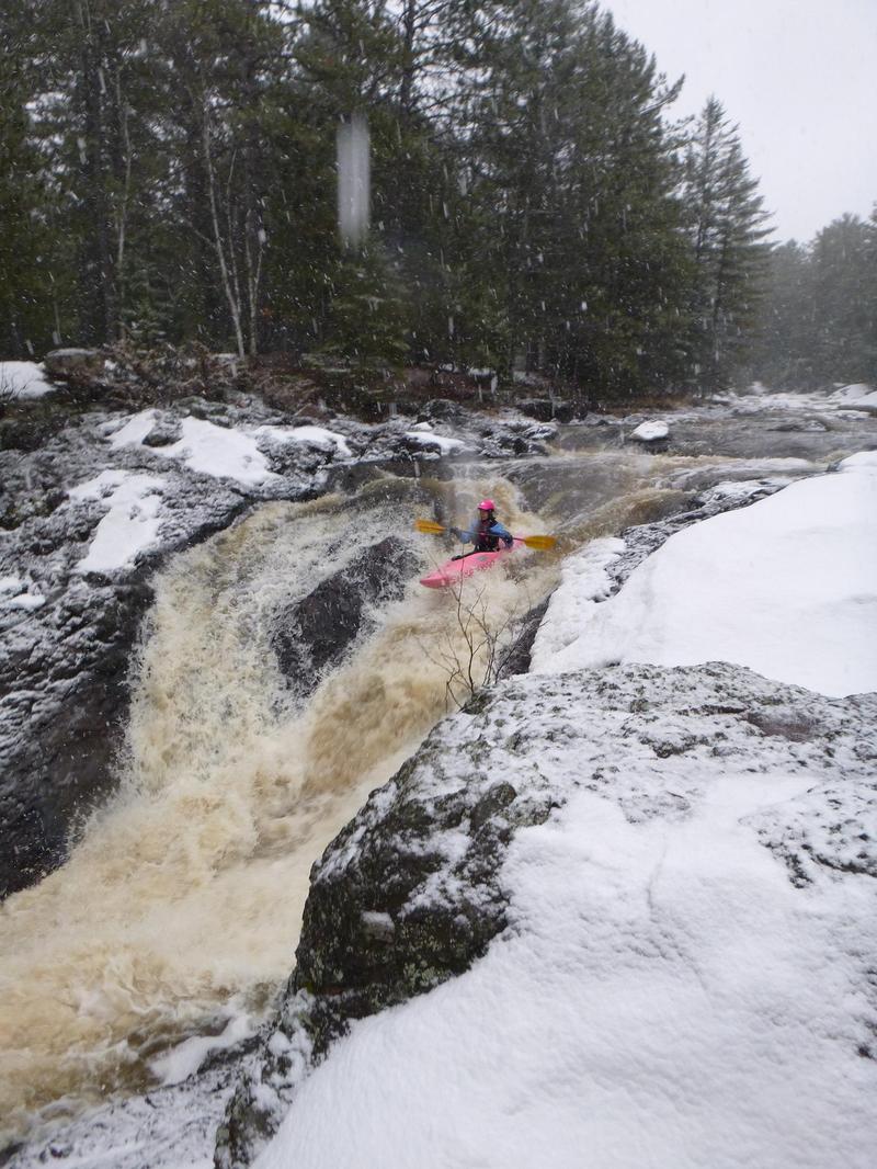
A footbridge and split channel mark the beginning of the falls sequence. Take-out above the footbridge to scout. The right channel carries the most water and is most commonly run. Below the bridge a steep drop of ~15' may generate an aggressive hydraulic at its base. A short distance downstream, the river twists and drops off a second falls of about 15'.
Note: there are splines of rock in the pool below, running parallel to the face of the drop and fairly close in. (These were no doubt formed as the falls, over time, has receded upstream, apparently in uneven 'chucks'. The resultant bottom contour is like the corrugated layer of a corrugated cardboard box.) These shallow splines generally preclude runs of this drop at low-to-moderate flows. You must be jus
...
Drainage area at our listed put-in is approximately 108 sq.mi. (as calculated via USGS StreamStats Beta software).
Uncertain about legality (property ownership), but aerial (satellite) view shows a road stub and no buildings at this site. A clearing appears to lead to good river access, as an alternative to the listed put-in.
The most significant rapids of the 'upper stretch' (before the falls sequence in the state park) comes just after a sharp left-hand bend in the river.
USGS lists a sampling site here with drainge area of 113 square miles.
The nearest active USGS gauge is on the Nemadji where it has drainage of 420 square miles. Thus, flow here might be about 1/4th the flow on that gauge. (Ratio of drainage areas is 0.269)
A sixty-mile section of former railroad line has been converted into a multi-use trail.
At a large island in the park the main flow (straight ahead) goes over a couple major falls. A much much smaller channel splits sharply to the left to head into the 'Snake Pit'. If you haven't thoroughly scouted this area already, this is your final chance to get out and to have someone set safety (and/or shoot video from shore) for anyone running the main drop sequence.
With adequate flows, the river-left channel becomes runnable and offers a very interesting drop sequence.
A sharp right turn contains an apparent rapids (maybe a minor ledge/drop?). Additional light rapids intersperse the remaining two miles to our listed take-out.
Again, the most vertically addicted boaters may attempt a park-and-huck of the action within the park, hoping to avoid any interference by authorities. Some boaters doing the full run may attempt to take out as soon after the action in the park, again hoping for minimal interaction or interference from officials. We prefer extending to our listed take-out as an attempt to minimize hassle. The overall run is just not inordinately long, and flow should move well on the lower-gradient portions of the run.
Apr 6, 2013
Spring run down First Falls at Amnicon State Park 4/6/13. Lower Falls and Snake Pit were not runnable due to ice.
Apr 28, 2009
Used to hike here all the time while in college in Superior. Great river with some big drops. I recall the first waterfall to have rock in the base but with high flow it could be o.k. the other one is a slide and it was very clean. I have heard that there are more big drops upstream (south) of the park.
Jun 5, 2008
This used to be one of my favorite spring runs. I dont know the date when the park opens but many times the river is at peak flow when there is still snow on the ground. This is the ideal situation for this run, no rangers to fuss with & if you go when raining no public either. At these elivated flows the 'normal line' becomes incridibly scary however the snake pit really goes off. If you live near by this little section is sweet!