Elk River
2. Elk Springs(fish hatchery) to Bergoo
| Difficulty | II-III+(IV) |
| Length | 12.1 mi |
| Avg Gradient | 40 fpm |
| Gauge | Elk River Below Webster Springs, Wv |
| Flow Rate as of 42 minutes | 3.54 ftbelow recommended |
| Reach Info Last Updated | September 10, 2016 |
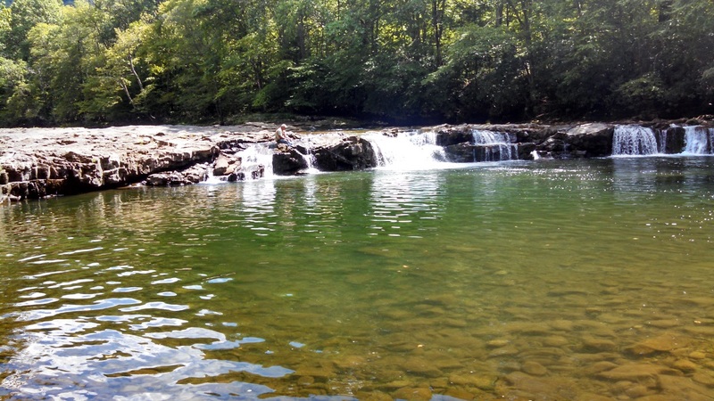
This section includes Whitaker Falls. It is easy to scout from roadside while running shuttle. There are numerous options for putting in or taking out.
Sep 10, 2016
Whittaker Falls on a day with far too little water.
Sep 10, 2016
[Original post date is 4/2009. As noted at the bottom, Robert is describing a longer run than just this section; edits are in brackets] Robert Farmer---Hi, I did this on April 4, 2009. The level was about 6.6/2500 on the telemetric/internet gauge at Webster Springs, which I've been told is 3 feet higher than the visual gauge on the right side of the island in WS. I found it to be mostly Class 2, with perhaps a spot of 3. This is a roadless wilderness section [for about the first 5 miles] that has an old, abandoned railroad on river right. I put in at Slatyfork, about 0.25 mile off of Route 219 immediately upstream of the confluence of Slaty Fork and Old Field Fork, and downhill of a lumber yard. The trip to the first road/trailhead took 1.0 hour exactly. Not having read the description in a while, I was surprised when the large, wide, high-volume river that I was on turned into a small, narrow creek! Quite interesting! After running alongside a road for a little bit, a ledge of about 4 feet appeared, which I scouted on the right. Below here I was pleasantly surprised to find a delightful Class 4 boulder garden that went on for a half-mile or so. A few other rapids are scattered in between easy sections, although the current was always moving nicely; in fact, the water soon started feeling a bit pushy, even though it was usually fairly shallow---odd. Soon, Whitaker Falls appeared, which I had previously scouted while driving up alongside the river, as it is right next to the road. There is an approach ledge that I ran about 1/3 from the left shore through a break, and I ran the final 8-ft-or-so drop tight left, about 20-30 feet from the left bank---Class 4, I'd say. The river here is about 120 feet wide, I'd guess---rather unusual for a whitewater river. You should scout this on your shuttle drive. Beware: the middle part looked like a drowning machine. Although the guidebook recommends the right side, the ledge is pretty irregular over there, and the hole looked somewhat stronger than on the left. I was happy with my decision. Below here is another ledge of about 4-5 feet which I ran on the right, although center would have been good if I had remembered the line there better. Below here the rapids come more slowly, with good rapids every mile or so down to Bergoo, which is where the road makes a 90-degree turn at a one-lane bridge and a fishing shop and small community. The best rapids always seem to be out of sight of the road. A good approach for someone who wanted to cherry-pick the hardest section would be to drive up Bergoo Road (CR 26) from [WV 15, about 4 miles north of] Webster Springs and make the right turn at around the 21 mile point (CR 60) [this puts you on the next section], and put in from the trailhead up that way. This would avoid about 10 miles of Class 2; or, if you want the Class 2 bits only, set your takeout here. (I didn't have time to drive this section of road, as I for-some-reason connected back to Route 15 instead[CR 26 continuing east leaves the Elk and follows a tributary to CR 49, then WV 15].) Then drive down as far as you want, probably somewhere below Whitaker Falls. Upstream of Bergoo, the road is on river right and is very high up for a while. Below Bergoo, the road is on river left for a while before crossing back to the right. In summation, this section was quite enjoyable and better-than-expected. And most of it is roadside, which makes the shuttle and road-scouting a breeze. You should do it sometime. (Final note: I don't know where Elk Springs is [it's about 10 miles from the put in, where CR 26 meets 60 (Elk River Rd on Google Maps)], and ; the guidebook lists only one section from Slatyfork to Bergoo, of about 20 miles, so that is what I described here.)
Sep 10, 2016
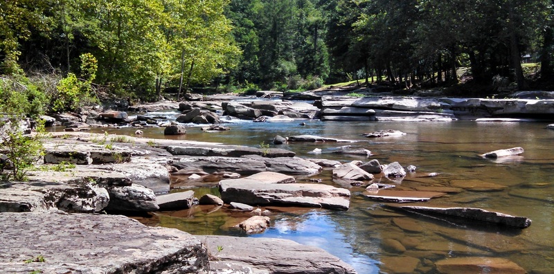
Somewhere a bit upstream of Bergoo, with far too little water.
Mar 28, 2009
I've run this section at many different levels, it is a fun easy run with a shortened run from just about 3-4 waves above Whitaker to tressel bridge that crosses the road about 2-3 miles down. Not sure exact mileage but there looks to be a fun wave to play at tressel bridge when water is a little on the bhigher side of things.
Apr 9, 2004
4 April 2004. Put on just below Whitaker Falls and took out past Bergoo, below Cherry Falls. Water level around 5.8 feet or so. Good run, just a litle scrapy at spots. Class II-III all the way. Cherry Falls was fun, with many trout fishermen as spectators! River was generally open, with only one fallen tree to carry around just below Bergoo. Also looked at the Gorge above the fish hatchery, but was too low to run. Good water, cold weather. Didn't run the next day due to a total accumulation of 8 inches of snow at our campsite just below Whitaker Falls. Fishing was lousy, with only three trout caught on 3 April by my friend Greg.
Jul 15, 2002
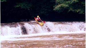
This level is considered below runnable for the reach, but the falls are apparently runnable at this level.