Elk River
2. Elk Springs(fish hatchery) to Bergoo
September 10, 2016
| Reporter |
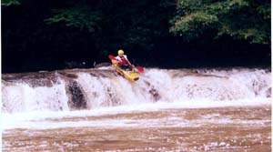
[Original post date is 4/2009. As noted at the bottom, Robert is describing a longer run than just this section; edits are in brackets] Robert Farmer---Hi, I did this on April 4, 2009. The level was about 6.6/2500 on the telemetric/internet gauge at Webster Springs, which I've been told is 3 feet higher than the visual gauge on the right side of the island in WS. I found it to be mostly Class 2, with perhaps a spot of 3. This is a roadless wilderness section [for about the first 5 miles] that has an old, abandoned railroad on river right. I put in at Slatyfork, about 0.25 mile off of Route 219 immediately upstream of the confluence of Slaty Fork and Old Field Fork, and downhill of a lumber yard. The trip to the first road/trailhead took 1.0 hour exactly. Not having read the description in a while, I was surprised when the large, wide, high-volume river that I was on turned into a small, narrow creek! Quite interesting! After running alongside a road for a little bit, a ledge of about 4 feet appeared, which I scouted on the right. Below here I was pleasantly surprised to find a delightful Class 4 boulder garden that went on for a half-mile or so. A few other rapids are scattered in between easy sections, although the current was always moving nicely; in fact, the water soon started feeling a bit pushy, even though it was usually fairly shallow---odd. Soon, Whitaker Falls appeared, which I had previously scouted while driving up alongside the river, as it is right next to the road. There is an approach ledge that I ran about 1/3 from the left shore through a break, and I ran the final 8-ft-or-so drop tight left, about 20-30 feet from the left bank---Class 4, I'd say. The river here is about 120 feet wide, I'd guess---rather unusual for a whitewater river. You should scout this on your shuttle drive. Beware: the middle part looked like a drowning machine. Although the guidebook recommends the right side, the ledge is pretty irregular over there, and the hole looked somewhat stronger than on the left. I was happy with my decision. Below here is another ledge of about 4-5 feet which I ran on the right, although center would have been good if I had remembered the line there better. Below here the rapids come more slowly, with good rapids every mile or so down to Bergoo, which is where the road makes a 90-degree turn at a one-lane bridge and a fishing shop and small community. The best rapids always seem to be out of sight of the road. A good approach for someone who wanted to cherry-pick the hardest section would be to drive up Bergoo Road (CR 26) from [WV 15, about 4 miles north of] Webster Springs and make the right turn at around the 21 mile point (CR 60) [this puts you on the next section], and put in from the trailhead up that way. This would avoid about 10 miles of Class 2; or, if you want the Class 2 bits only, set your takeout here. (I didn't have time to drive this section of road, as I for-some-reason connected back to Route 15 instead[CR 26 continuing east leaves the Elk and follows a tributary to CR 49, then WV 15].) Then drive down as far as you want, probably somewhere below Whitaker Falls. Upstream of Bergoo, the road is on river right and is very high up for a while. Below Bergoo, the road is on river left for a while before crossing back to the right. In summation, this section was quite enjoyable and better-than-expected. And most of it is roadside, which makes the shuttle and road-scouting a breeze. You should do it sometime. (Final note: I don't know where Elk Springs is [it's about 10 miles from the put in, where CR 26 meets 60 (Elk River Rd on Google Maps)], and ; the guidebook lists only one section from Slatyfork to Bergoo, of about 20 miles, so that is what I described here.)