Charles
1. Needham Rapids

| Difficulty | I |
| Length | 0.2 mi |
| Avg Gradient | n/a |
| Gauge | Charles River at Dover, Ma |
| Flow Rate as of 1 hour | 43 cfsbelow recommended |
| Reach Info Last Updated | June 11, 2018 |
Contributed by Jim Cavo:
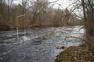
There is about 200 yards of fast Class-I water at the outflow of a dam. There are about 25 slalom gates hung year-round. Strong eddy lines, although the river is too shallow for squirting. Good training site, runs regularly late fall through mid-spring and after heavy rains.
From Route 128: Take Exit 17 and head west .6 miles to traffic light. Left onto South Street. After .6 mi., bear left at fork (stay on South St.). In .5 mi., go straight at stop sign at Chestnut St. In 1.4 mi., cross the river at a dam and park just ahead on either side.
Thanks for the great info, Jim!
Jun 9, 2013
Paddled this today - June 9, 2013. The put in is on the western side of the river at the end of Mill St in Dover, right by the bridge. There was an open gate and a path that goes down to the water.
Not very exciting. Barely 100 yards of quick water with a couple small rapids. Watertown Square was more exciting for me.
Water quality terrible, not recommended as a place to play or surf.
Apr 28, 2012
The directions above were confusing to me so I just wanted to post the LatLng coordinates so people could search for it themselves if they wanted. Here they are: 42.25907, -71.26311
Or, just sue this Google Map link: http://maps.google.com/maps?q=42.25907,+-71.26311&hl=en&sll=42.255967,-71.264191&sspn=0.038212,0.037336&t=m&z=17
Jul 11, 2009
Only one cross-wire with a single pole on it at this site these days...
Dec 27, 2006
Gates on the Charles at Needham Rapids