San Joaquin
3. Horseshoe Bend (Redinger Dam to Kerckhoff Reservoir)
| Difficulty | III-IV(V) |
| Length | 7 mi |
| Avg Gradient | 33 fpm |
| Gauge | San Joaquin at Horseshoe Bend |
| Flow Rate as of 30 days | 81 cfsstale data |
| Reach Info Last Updated | May 19, 2016 |
The San Joaquin River is one of California’s most significant whitewater rivers, flowing from the high Sierra Nevada through the steep granite walls of the San Joaquin River Gorge Special Recreation Area. It is also one of the most intensively developed hydropower rivers in the state. For over two [...]Read More
Horseshoe Bend is a beautiful section of river that has seen relatively little boating use in the past. It only has boatable flows during periods of spill; typically late Winter and Spring of an average to high water year. Many years there is no spill at all and therefore no boatable flows. Scheduled weekend recreation releases will happen in the future if certain fishery studies allow it. In the meantime SCE started providing real time flow information in the summer of 2006, which will allow boaters to use this reach whenever there is boatable flow.
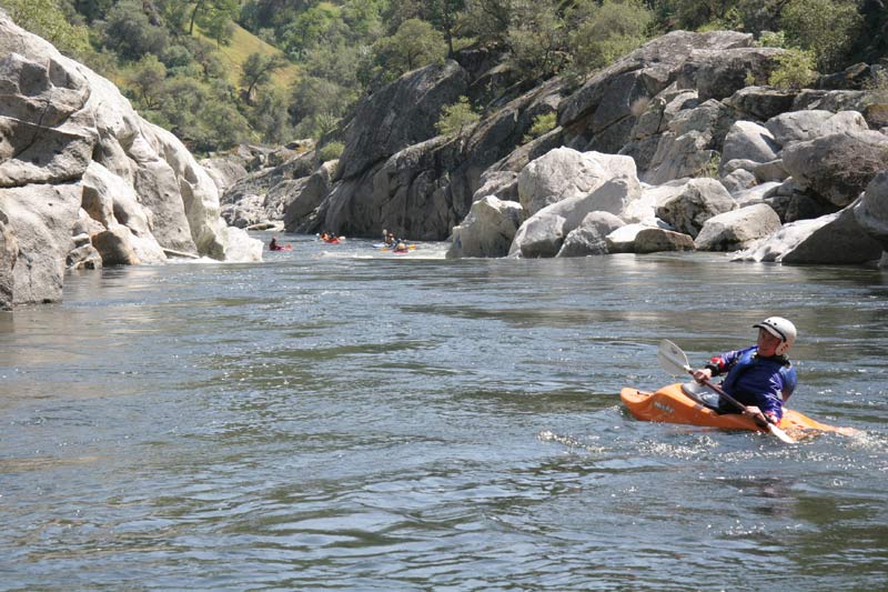
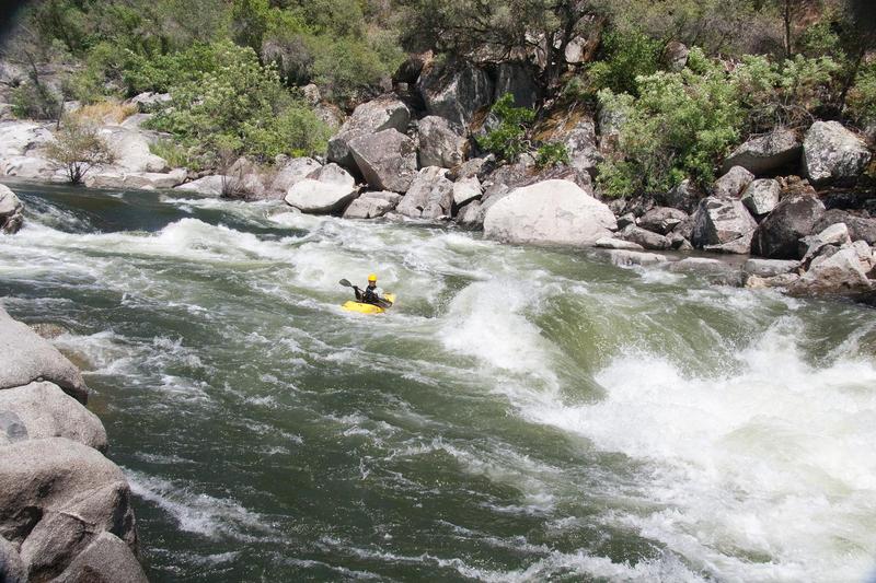
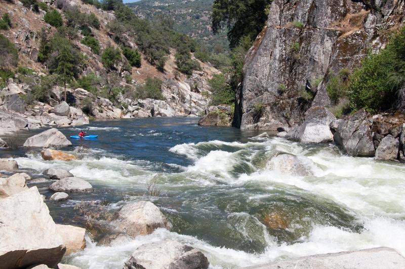
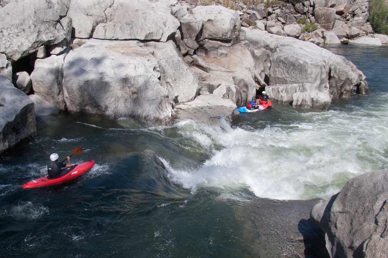
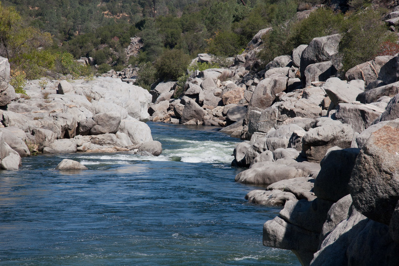
The river character is classic pool drop, with long pools separating relatively short steep drops. The streambed is a deep granite trench and many rapids are formed by large boulders. Most rapids, even the small ones, have distinct horizon lines, which hide any view of the correct route until you are just about entering the rapid or have in fact committed to the rapid. Low cliffs or sculpted boulders form much of the shoreline, but all rapids are easily scouted from shore. There are a few small beaches along the length and one large beach at about the halfway point. It is a very pretty section of river.
Time required: One can enjoyably spend all day, but fast trips are also feasible. A recent kayak trip at 2000 cfs with 3 boaters, doing 4 scouts, two portages, 1 swim, and numerous rolls, took 2 hours and 15 minutes from put-in to take-out.
The Horseshoe Bend Trail is on river right. It comes close to the river in a couple spots, but usually it is several hundred yards up on the hillside. Sometimes its path is obvious but in many other areas it is faint. The downstream end of this trail starts where the road to the powerhouse is gated. The upstream end starts from a level area a mile before you reach Willow Creek. At the upstream end, there is a sign for the trail and a dirt road leading to a power tower. Vegetation in the area is grasslands, brush, oaks and some Dig
...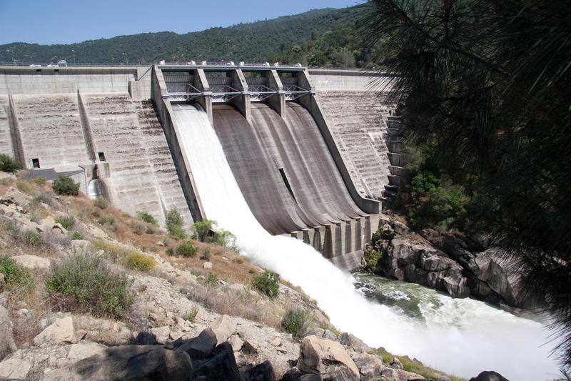
Redinger Dam diverts 3,600 cfs to the Big Creek #4 Powerhouse and controls flows into Horseshoe Bend. During spill events, the gates rotate upwards slightly to create a gap underneath to release water. The gap under the gate is usually 10 or 15 feet below the surface of the reservoir, so the water released is cold. One gate open is typical. Two gates open means really big water and only the hard core will want to challenge themselves.
Some people do or have launched just downstream of the dam, but getting to the river requires descending steep and very exposed slabs that are very wet and very slimy. A better but still very steep put in route is to descend a trail from the access road gate to the gauging station,

This is the best put in option for paddling through the Redinger Gorge. Look for the gated road leading down towards the base of the dam. A sign on the gate says, 'Dam #7' The trail starts just outside the gate and leads straight down the hill. The trail is not in great condition but it is discernable. There are some stairs and ladders near the bottom.
A moderate rapid leads to a very big rapid, class 4+ to 5. It can be portaged over boulders on the left. There is a big splat rock in the middle of the rapid and the release flows of 1600 cfs are too low to provide a good line around it.
As you drive down the road towards the start of the run you will get a good view of the dam. You can see the official parking area at the same time. It is next to and sllightly above where the big aquaduct pipe emerges frrom the hillside. Drive down across Willow Creek, then back up towards the dam. When the paved road levels out, the side road to the parking area cuts sharply back. It is a sharp tight turn when going towards the dam, but an easy turn coming from the dam, so just pass it and use a turn out to turn around. The parking area is big, but has no shade.
A wide trail leads from the parking area to the river. It is a little ways to carry boats, but all downhill. At the river, there is only space for a few rafts at a time.
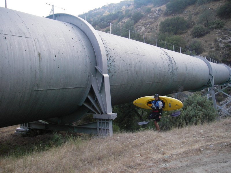
A loop road on the east side of Willow Creek leads to a fairly large unloading area by the auquaduct pipe. A trail leads underneath the pipe and out to the main river. This trail is narrow and awkward for groups carrying rafts and has been replaced by the official parking area above.
The newer parking area and raft put in has been constructed uphill to the east of Willow Creek. Stay on the paved road across the creek heading east. The road turns south and climbs uphill. Shortly after passing above the penstock pipe, the road turns east again. A dirt road cuts back to the west and drops to a large level area. Park here. A trail leads steeply down to the river.
This was the standard put-in location to use before the official parking area and put in trail were constructed. When Willow Creek has enough flow, kayakers can launch into the creek at the road bridge and boat the .35 of a mile to the river. It can be very brushy.
There is usually a thick growth of bushes across the main river downstream of Willow Creek. They grow in the shallow sediment that gets carried down Willow Creek and deposited in the relatively wide and slow main river channel.
Look for a boulder on river right just downstream of Willow Creek. A staff gage is affixed to the downstream face. It is marked in 500 cfs increments and goes up to 5,000 cfs.
Because of the trees growing across the exit from this pool, the gage always reads high, typically by 500 cfs or so. However, the error may vary from year to year as trees grow bigger in low flow years or get washed out in wet years.
FERC Article 402, required the installation of a staff gage marked in 500-cfs increments at a location downstream of the confluence of Willow Creek and the San Joaquin River.
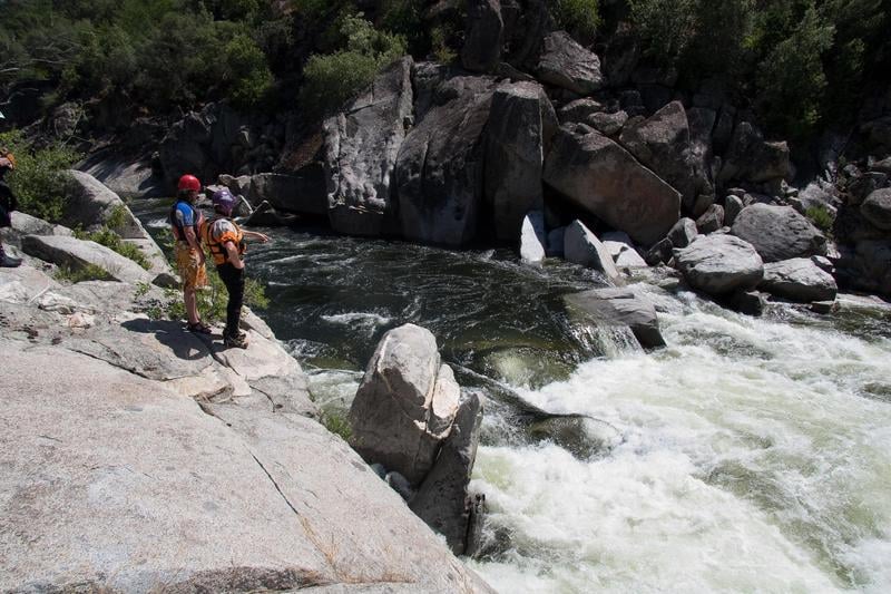
After a mile of mostly flatwater, cliffs develop, especially on the left. A group of large boulders block the channel. To scout, take out upstream on the right. At low flows the center slot is clean and the right side develops a route. At high flows the left side cleans up while the center develops into an ugly hole.
If the flow is below about 1500 cfs, rafters will have to portage this rapid by pulling their boats over the center boulder. At flows up to at least 2400 cfs, the center route is still good, while the left route is still shallow. At flows around 3,000 cfs and up, the left side route is better.

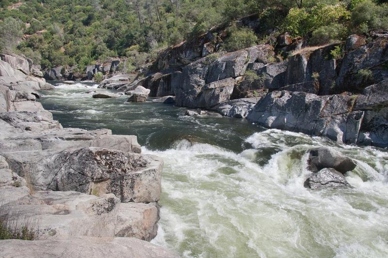
Granite cliffs rise on both sides of the river, creating a long scenic section. A series of moderate rapids are scattered throughout. Many of these rapids have holes to avoid, and most create weird and strong hydraulics in the tail water. There can be fantastic play spots at some flows.
Boulders on river right block your view of this sharp right turn. Rocks in the middle of the entrance force boaters to go far left at lower water the paddle hard to get back right. At 2400 cfs a left of center chute is open that reduces the effort of getting right. Around 3500 or 4000 cfs a steep drop on center right is open. At lower release flows the current pushes boats towards a big hole on the left. Paddle hard to get right. Another large hole hides in the middle in the tail waves below. Scout or portage on river right. Boat scout on river left. There is a long recovery pool below. A few boaters have had deep dark swims here after being separated from their gear. One boater reports swimming underneath a boulder after dropping into the upper hole.
At 1600 cfs both holes are exposed bolders and there is even a narrow waterfall route to the left of the first boulder.
At higher flows (4000 cfs) the lower hole washes out and dissapears, but the upper hole gets bigger and bigger.
This is a relatively big but clean drop. There is a fairly obvious ledge hole near the top, just right of center that is easy to avoid. I think it is top right, but keep your eyes open! The main line is down just left of center, but there is also a narrow line down the right edge between the hole and the cliff.
The river banks spread out and flatten out to some extent in this area. There is a blocky island in the middle with an overflow channel on the left and the main channel on the right. Obvious obstructions under the surface create complications in the center and right. Boaters must enter near the center but most charge to the left edge to avoid the obstructions at the top. This lines one up perfectly aimed at an ominous spray/splat rock. Most seem to shoot over it, but getting to the right seems wise. One can wander farther a field if they wish to punch weird diagonal ledge holes. If one tips over in this rapid, expect to hit rocks. Tuck up and stay in your boat till it cleans up. A good size hole also waits in the middle right of the tail waves.
At 4000 cfs this rapid cleans up into a fun big wave train.
Below this rapid, flat water and small rapids lead to the far portion of the 'Bend'.
The river turns right into the bottom of the horseshoe and heads west. The small Backbone Creek comes in on the left and forms the nicest sand bar on the section. Flat water allows one to enjoy the beautiful cliffs and scenery for the next .3 of a mile.
Big rocks obstruct the middle and left at the top of this steep drop. Enter on the far right, aiming diagonally left between a big hole on the right and the turbulent recirculation from the rocks blocking the middle top. Once past the right side hole, immediately cut back right to avoid a huge ledge hole on the left. Once past this left side hole, aim either far left or far right to avoid the big hole in the bottom middle.
The river turns back north and immediately comes to 'Little Dog', the lead in rapid to 'Big Dog'. An easy take-out for scouting is on river left. Scramble over some boulders to reach a sloping ledge that runs some distance along the river. You can scout all of Little Dog from this ledge and get a fair view of the entrance to Big Dog. With some rope work or strong climbing skill, you get onto the next ledge and probably scout Big Dog as well.
There are left, center and right routes through Little Dog. The center has more water at lower flows, but the side routes look easier at higher flows. A second drop just downstream is down the center but steep and very turbulent. WARNING! Only about 40 yards of swift water separates the end of Little Dog, from the beginning of Big Dog. If someone swims out of Little dog there is a danger of also swimming Big Dog. At 3000 cfs the two rapids are starting to run together.
The most commonly run line is to take the narrow center chute and paddle hard towards the right. If you do not make the move properly, the current will push you back to the left towards an undercut boulder. If you eddy out on the left above the rapid, you will be perfectly set up to enter the rapid at the right angle and with enough momentum.
When boaters exit Little Dog, they have a choice. Paddlers can head right to a small take-out, from where it is easy to scout, and easy to portage if so desired. At higher flows it can be very difficult to get into this eddy. Alternatively, boaters can paddle left towards several different eddies behind boulders. The lowest left side eddy situates one perfectly to run the center chute.
During busy releases when flows are 1600 cfs, the take out here can get very crowded. Rafts can tie up about 30 feet upstream where ledges come down to water level.
At the 1600 cfs release level, the most commonly used line by kayakers was to take the center entrance and drop into a narrow seam between the big rock on the left and the big hydraulic on the right. From there they paddled through a narrow gap to the right of a yellow rock.
A few kayakers got stuck in a backed up hole halfway down on the right which discouraged others from going that direction.
Rocks and holes and maybe a tree in the middle encourage boaters to enter far right. The rapid curves gradually to the left past an overhanging right wall. Boaters must paddle to stay away from the overhanging right wall, without going so far as to end up in a big hole on the bottom left side.
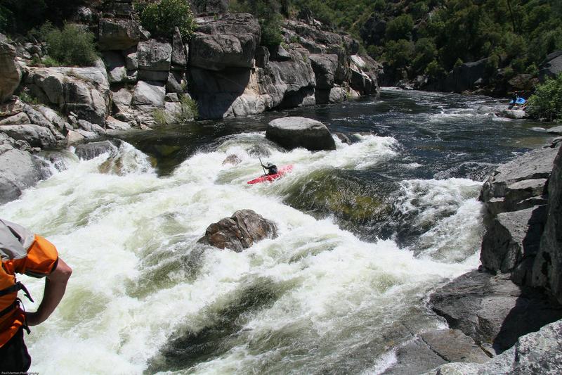
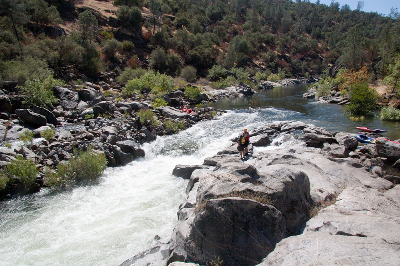
The river enters a large round pool with a very narrow exit. The rapid is a single steep drop. It is impossible to see the drop from a kayak, before committing to it. Always scout if unfamiliar with the drop or the flow as there tends to be strong recirculation at the base. Boats have to punch one side or the other of the hole, but the exact best line may vary with flow. Down the left side is usually best, but I am not sure if it is always best. Scouting from river left is easiest at higher flows but easier on the right at low flows. The right wall below the drop is very undercut at medium high flows and there is a strong eddy current going under it. If swimmers or equipment get pushed into this eddy, it can be awkward to reach them. Because of the undercut right wall, I think it is safest to always run the left side when possible. Scout to be sure.
The danger of the left side run is that the current often pushes boaters into an outcrop on the left. It takes some effort to push off and into the current. Kayakers can flip against this wall and get stuck there.
Constriction Rapid from Paul Martzen on Vimeo.
This is the 3rd large rapid below Big Dog. It is fairly steep and pushy, but relatively clean. As usual, the horizon line and a wide green wave near the top hide any view of the route until one is committed, at least for kayakers. You may get a little better view entering from the left side.
The big wave at the top is reportedly good for surfing at release flows around 1,600 cfs. There is a good eddy on the left to drop into the wave. But, once you come off, you are into the rapid. This wave is very wide and probably the biggest wave on the run at release flow.
At flows above 3,000 cfs and probably a bit less, this rapid funnels into a large wave. At lower flows the wave has a strong reversal, fills the channel and is an automatic boat flipper. Kayaks are cartwheeled and flushed once empty. Rafts can be flipped and held. Swimmers flush immediately but deeply. There is an easy scout or portage on the left, but it can also be scouted on the right.
There is also a man made side channel to the right which offers a fairly easy sneak route for kayakers. The exit from this side channel can get choked with bushes, so stay straight when you bash through them. Also there may be some bolts or rods in the streambed that damaged one kayak. We hope to remove them at low water.
The powerhouse often adds 3,600 cfs of additional flow. The water wells up from underneath then pushes everything over to the left. Relative flat water continues one mile to the highway bridge at Kerchoff Reservoir.
During scheduled releases, the powerhouse will be off and a class 2 rapid appears, leading into the powerhouse pool. There can be a good surf wave at the top of this rapid.
Boaters can hike down the road to the powerhouse and launch into the river here, if they wish.
Take out under the bridge on river right. Carry back upstream along a more gradual trail, up to the old road and then back across the highway to the parking area. Avoid going straight up the hill next to the bridge.
Some rafters prefer to paddle across the lake to a beach where it is easy to unload. There is plenty of parking close to the water and boats don't have to be carried very far. There is a modest current across the reservoir, so if you are patient, you don't even have to paddle much.
May 16, 2025
Excellent flow with 2400 cfs and nice warm day. We scouted Study Rapid, Little Dog and Big Dog. At Study Rapid, the center route was still good, while the left line was still shallow. The right side line looked weird, as usual.
At Two Holes Hiding, the center chute had plenty of water making the move to the right around the big hole much easier.
Long and Shallow was great.
Big Dog let us through without too much damage. No swims.
Wahoo earned its name again. Biggest waves of the day.
Both Constriction and Powerhouse Hole delivered big hits, but let us through without flips or swims.
All concurred that this is a beautiful section of river.
Jun 13, 2024
Jun 12, 2024