| Difficulty | II-III |
| Length | 5.8 mi |
| Avg Gradient | 27 fpm |
| Gauge | Deckers Creek at Morgantown, Wv |
| Flow Rate as of 24 minutes | 29 cfsbelow recommended |
| Reach Info Last Updated | September 25, 2003 |
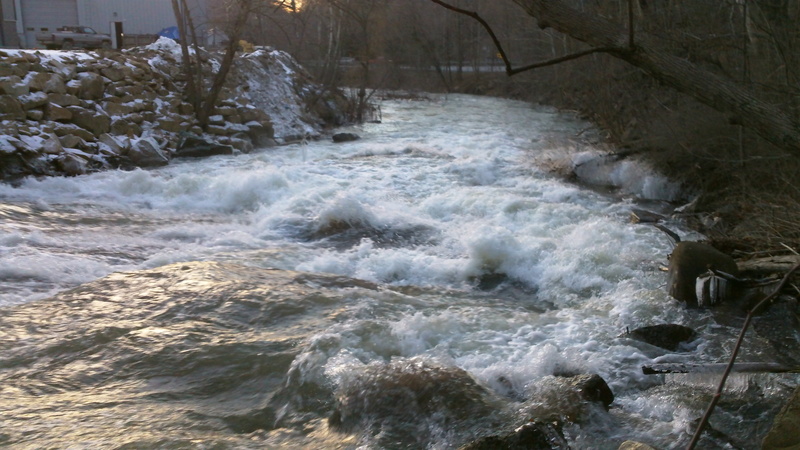
River Description
Gradient, by mile: 30, 60, 20, 20, 15, 15.
Conservation organization: check out Friends of Deckers Creek.
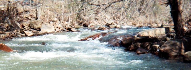
River Features
Put In
Access PointDistance: 0 mi
Take Out
Access PointDistance: 6 mi
Trip Reports
Log in to add a reportBV
Bob Vernon
Sep 27, 2018
Ran this today at around 400. Although there are some trees in the stream I was able to get around or over all without portaging. I agree that it is not a challenging run for experienced paddlers but it is a fun urban run that is very convenient if you live in Morgantown. If you have less experienced paddlers avoid higher levels and put in below the first mile or so. I am an experience paddler and enjoy this stream which includes taking out behind the West Virginia brewery in Morgantown.
AL
Alec Lazarides
Apr 21, 2017
Ran this at 676cfs, was a great time.
?
Untitled
May 18, 2011
There is a new tree down in lower Deckers about a half mile down from Dellslow bridge. There is no way around on the right, on left is a 2-3 ft slot you can slip through, or an easier quick portage.
?
Untitled
Mar 10, 2011
At 500 cfs the slide above bridge. River left had some type of metal or logs lodged in a hole, can't really tell in picture, but make sure its clean if choose to run over there.
?
Untitled
Mar 10, 2011
I ran this after class early February at 500 cfs in a playboat. I started upstream of the slide above the bridge and took out at the big parking lot beside the hotel after going under the overpass. It was a fun run, but at this level the first mile or so is pretty nonstop. Nothing really surprising, but if you struggle hitting eddies then try it at a lower level unless you are in a group. After the first part it really calms down and is rather uneventful. The slide and rapid above the bridge looks meatier than it really is at this level, just stay away from the left side which looked to have some type of metal or logs jammed in a strong hole over there. Otherwise, all boat scoutable, and as of February there was a way through all the downed trees if you stay with the current.
Also, for any who care, nice little surf waves develope at several ledges, including one around the overpass, if you are learning to surf, then try it out when levels are high.
KS
Kevin Schultze
Apr 17, 2009
At 350cfs the bridge outside Marilla Park can become a problem for everybody. We had to exit the boats and sort of walk them under low bridge. There are two small arches. The middle arch (right) has a large underwater structure right before entering and then drops off. Safer to swim under the left side. Had a great time throughout the run though. Very easy access in and out
KS
Kevin Schultze
Apr 5, 2009
Ran at 250cfs today. Proved to be challending during the first 1/2 mile and fun throughout. Hardly had to worry about shallow areas at all. Please note the very low bridge when approaching Marilla Park in Sabraton (about 1mi outside of Morgantown). One of our taller kayaker's had to beach and walk the structure.
KS
Kevin Schultze
Mar 31, 2009
This is at the Dellslow bridge (put-in for the ride into Morgantown)
?
Untitled
Mar 27, 2009
Very nice 6 mi run for beginners and intermediates. Starts off with some fun II's and a III here or there mixed in, with the last half pretty easy. The creek gets progressively calmer as you near Morgantown and provides great scenery. There is a jogging/biking trail that follows the creek nearby for the majority of the run, but other than that, you probably won't see anybody else out there
LOCATION START: Good Start point is at the intersection of Pixler Hill rd and Rt. 7 (earl core rd.). If coming from Morgantown or I-68, Pixler Hill rd is about 1/8th of a mile before Tyrone rd. At the intersection of Pixler Hill and Rt. 7 there is a bridge crossing the creek. This is where we put in, but parking was hard to come by. We ended up leaving the car on the side of an offstreet after dropping the kayaks off.
LOCATION END: A good public lot at the end point is at Hazel Ruby McQuain Riverfront Park. This is where the creek dumps out into the Monongahela river. It is also near the intersection of Beechurst and the Westover Bridge in Morgantown. Any parking down by the river near this is suitable as you can paddle to you car's area.
Also, if you want a shorter trip or one omitting the easy stuff, you can park near the exit of I-68 and rt.7 (sabreton exit) as your endpoint. There is a big gravel area near the offramp where you can park without trouble. This will be a 2.5 mile run or so of mainly II and III.
WARNING: Starting your run any further east (away from Morgantown) down Rt. 7 is very difficult. Just scouting all the large boulders and drops made me a little nervous. Some real IV's and V's that way. Experts only. Everything west of Tyrone rd. and Pixler Hill Rd is realtively safe though.