| Difficulty | V+ |
| Length | 0.9 mi |
| Avg Gradient | 341 fpm |
| Gauge | Meadow River at Nallen, Wv |
| Flow Rate as of 1 hour | 202 cfsbelow recommended |
| Reach Info Last Updated | October 1, 2003 |
River Description
Rapid names include:
What a Way
Man o Man
Energizer
Around the Bend
Tunnel of Love
Long and Twisted
Normally a Portage
Final Frontier
Pop Top
From there you will hit the confluence with Glade, and have a screaming high-water paddle out on Manns.
Brad Roberts shared on 2002-11-11:
From Boatertalk:
For those who run Mann's Creek, the river-left gauge has changed. They put a bunch of concrete in around the gauge rock, but the gauge still works. We ran it the other day at +8 inches, which seemed to us to be more like +3 inches on the 'old' gauge. Some other people ran it around 0 and said that seemed more like -4. I'd say the gauge actually has changed for the better, with 0 being more of an accurate 'low' level, and 8 inches (the top mark on the gauge) being more of a realistic top end. Most first-timers run it around -3 or 4, so now I'd say -1 or 0 would be good low levels.
Jimmy Blakeney
River Features
Put In
Access PointDistance: 0 mi
Take Out
Access PointDistance: 1.7 mi
Trip Reports
Log in to add a reportLB
Logan Bockrath
Feb 25, 2011
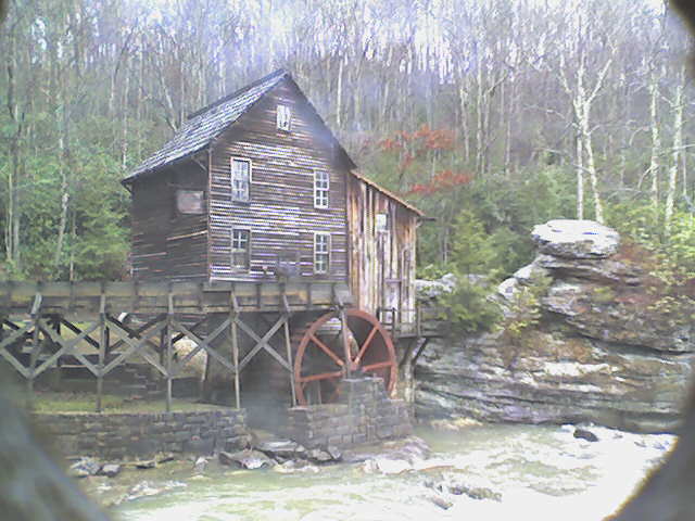
Recently the park has put up a live webcam image on their website (www.babcocksp.com) of the mill in which you can see enough of the creek to get a decent idea of what it is running. Here is a photo of the gauge at 2'.
BK
Bryan Kirk
Jan 4, 2011
The Boatertalk quote, along with Robert's comment, are referring to Glade Creek to the confluence of Manns, then down to the new on Manns Creek. This AWA page pertains to Manns creek above the confluence, AKA Real Manns Creek, which is much less commonly paddled.
RS
Robert S. Farmer
Feb 13, 2010
Unguided first-timers should allow at least 10 hours for the run. The first descent took ten hours. Maybe super-hot boaters can do it faster, but if you don't know the rapids, prepare for a very long day down to the New River.