Lockatong Creek
Just upstream of Idell to Raven Rock Rd.
| Difficulty | III-IV |
| Length | 4.7 mi |
| Avg Gradient | 72 fpm |
| Gauge | Lockatong Creek at Raven Rock Nj |
| Flow Rate as of 3743 days | 2.00 ftstale data |
| Reach Info Last Updated | July 2, 2019 |
This creek is often run after a heavy rain.
Stephen Strange contributes:
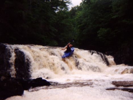
Lockatong Cr. has the exact same geology as the Tohickon across the river in Pa. but instead of getting rid of its gradient evenly, it occasionally dumps a bit of it all at once. There is a 12' waterfall and at least two other ledges that are 5-6'. If there is a day or two of hard rain in the late fall to spring, this and Wickecheoke will come up and can be easily done together in a day.
The put-in for Lockatong Cr. is off of the side road, which is off of Rte. 651
(The Coordinates are UTM 18 497815E 4478741N). Basically you are putting
in right at the confluence of the tiny tributary and Lockatong Cr., just
upstream of Idell.Though you can also take out at the picnic area on Rt. 29 along the Delaware (river-left for paddlers on the Lock.), most people take out at Raven Rock Rd. where it crosses the creek. The gauge is also there, on the river right abutment of the bridge.
Mar 7, 2011
The flow info page needs to be fixed. While it is possible to scrap down at 3.8 -3.9 (200-225 cfs) on the internet gage, 4.5' (400 cfs) should be the recommended minimum flow for running this. Also, the upper recommended level is too low. Most Class III/IV paddlers will have a blast at 1000-1200 cfs, which is 6-6.2' on the internet gage (9-9 1/4 on the old painted gage) and can handle it up reasonably well up to 1500 cfs (6.5' internet, bet 9 1/2 and 9 3/4 painted gage). Definitely runnable by skilled crews up to 2000+ cfs (7' internet, ~10' painted gage) but it does get pretty exciting at that level. Rule of thumb - If you have to hug your deck to get under the first bridge down from the put-in, it is not for the meek of heart. If you can't get under the bridge, consider another creek.
To summarize, here are my recommended levels:
Low = 400 - 575 cfs = 4.5' - 5.0' internet gage = 7 3/4 - 8 1/4 painted gage
Friendly Medium = 575 - 975 cfs = 5.0 - 5.8' internet = 8 1/4 - ~9 painted
Medium-High = 975 - 1500 cfs = 5.8 - 6.5' internet = 9 - 9 1/2 painted
High = 1500 - 2100 cfs = 6.5 - 7.2' internet = 9 1/2 - ~10 1/4 painted
Paddlers have been on it when surged to ~13' and have run the lower third at ~15-16' but these were apparently epic adventures and definitely not recommended. My recommendation is don't put on above 1500 cfs unless your with a strong crew that knows the creek since it is a fairly continuous flush the entire 4 plus miles.
One last thing, I have only heard of the Lock or Wick holding for more than one day once (after a tropical storm). You pretty much have to get on it the day of the rain or the next morning if it rains overnight.
Dec 13, 2010
400 cfs seems (4.5 on the internet gage) like a good minimum. Everything is runnable though the dam drop (right down the center ) wlll land you on some rocks. otherwise everything is runable. Note that as of 12/12/10 that Lock Falls is better run from the left channel due to wood in the main line. 2000 cfs is a good upper limit for most boaters. Gets pretty crazy at this level or above.
Dec 27, 2009
GPS coords
Put-in N 40*27.675' (Fishing access at Brook Road off CR519)
Take-out W 75* 01.515' (Raven Rock Road)
Jun 3, 2006
The approximate correlation is [Painted gauge = Internet gauge + 3.3 feet]
Internet levels: Bare minimum water to paddle all of the drops is about 3.8'-3.9, minimum fun level is about 4.5' and optimum is above 5.0'. Pretty hairy at around 6.5'. (updated 2006-11-24)
Jan 15, 1998
This is the big drop about halfway between Milltown Rd. and Strimbles Mill Rd.
Check out a full-sized version of this picture by clicking here.
Jan 1, 1900
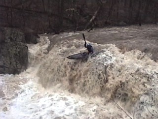
One of the many good drops on the Lock.
Steve showin' us how it's done in an open boat.