Carver Creek
Highway AA to County Road 114 (1 mile)
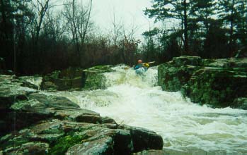
| Difficulty | IV |
| Length | 1.1 mi |
| Avg Gradient | 164 fpm |
| Gauge | East Fork Black River Near Lesterville, Mo |
| Reach Info Last Updated | November 25, 2010 |
(Big Creek tributary) Put-in and take-out are on private property next to roads. Be discreet.
MoCreekin’ has some good info about this and other creek runs in Missouri.
Logistics:
Carver Creek is off Hwy AA, just south of Taum Sauk Mountain State Park. To get to the put-in, begin in Ironton/Arcadia, MO at the intersection of Hwys 72 & 21, go south on Hwy 21 for 8.2 miles to Hwy AA, go right on Hwy AA for 2.2 miles to the Hwy AA bridge on Carver Creek, and park just beyond the bridge at the small pull-off on the right. Don’t block any driveways (with or without mailboxes). Check the gauge on the bridge to see if you have enough water. Walk down the road until you hear the sound of the first drop (about 100 yards) and head for the put-in above the drop.
To get to the take-out, go back on Hwy AA toward Hwy 21 for 1 mile to CR 114 (Victory Baptist Church) and go right on CR 114 for about ½ mile. The road goes down a steep hill and levels out with Carver Creek off to the right. Park off to the side at the place where the creek is next to the road.
History:
Carver Creek was first run in the spring of 1997 by Chris Amelung, Dennis Jones, Greg Brown, and Jerry Schafroth.
No trip reports yet.