Sovern Run
Co. Rd. 14-3 to Rockville
| Difficulty | IV-V |
| Length | 0.8 mi |
| Avg Gradient | 325 fpm |
| Gauge | Big Sandy Creek at Rockville, Wv |
| Flow Rate as of 42 minutes | 3.89 ftbelow recommended |
| Reach Info Last Updated | May 24, 2005 |
This small Big Sandy tributary has, as well as the ubiquitous downed logs every ten feet, a history of Acid Mine Drainage. Click here to read of Friends of the Cheat's successful project to improve Sovern Run! (Clicking will open a new browser window.)
From a post to rec.boats.paddle:
Creekin' Sovern Run Style!
November 26, 1999
Craig and Dave
Sovern Run begins on the hill high above Rockville, West Virginia, by meandering through a farm and cow pasture before making its approximate 200+ foot-per-mile descent to the Big Sandy. The cow pasture explains the bad taste of the creek but does it have anything to do with the class V rating! If you don't like 'em steep, narrow, slot filled, and hard to scout, go no further than reading this description or maybe driving beside it on the way to Rockville.
Craig and I scouted most of the run before deciding if we could/should run it. Starting at the bottom and working up river, nothing appeared too difficult until we reached the first rapid. Long and steep with 3 linked moves and no way to stop between them. A missed line could result in anything from a pin to a major loss of skin or emergency room visit. The line was complicated and not runnable, due to an unavoidable log sticking in the crux of the second move. Well, at least that was the case until 'Hercu-Craig' was able to move the log. The pending reality of running this rapid made my heart start to pound. It's one of those times when you know you are good enough but also know you can get hurt if you make a mistake. Few words were spoken as we dressed, a sure sign that we were undertaking something serious. After putting on, you have no warm-up. 50 feet and 2 micro-eddies later, you sit at the point of commitment. 'You going?, I'll go, You going?.' I reviewed the line in my head. Over a ledge, close to an undercut, don't get shoved under the bank,
...Apr 21, 2011
Broke my boat on this one last weekend, but I'm not mad at it. Here is some video from several years ago.
http://www.facebook.com/#!/video/video.php?v=1249760961450&comments&set=t.1152243703&type=1
And one from this year from a friend.
http://www.vimeo.com/20734759
Mar 1, 2008
paddled this a few weeks ago. suprisingly clear of wood! there were 2 trees but both were passable to the far right... i miss mike vanderberg
Sep 19, 2003
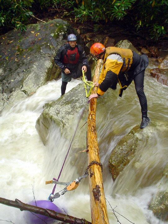
Check this area out carefully before running. The center slot (where Martin and Brian are trying to pop the Topolino free) is made for a vertical pin. We knew of the danger and had safety set up on the rock that they are standing on. Martin was vertically pinned with water over his ears. With Brian's help Martin was able to exit.
We eventually had to use a portable winch (come-a-long) and pull the boat straight up to retrieve it.
With some mechanical advantage and a strong log, we were able to free the boat.
Don't know if we dented the boat with our extraction or if the water force & rocks did it. Martin was able to hammer out most of the dent to finish the run.
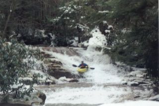
This photo was taken at the bridge support (river left) for County Road 14-3 near the Sovern Run put-in. At this level you may want to use someone else's boat or take a boat you don't like ;-) It's doable but scrapy.