| Difficulty | IV-V |
| Length | 13.9 mi |
| Avg Gradient | 137 fpm |
| Gauge | Pemigewasset River at Woodstock, Nh |
| Flow Rate as of 1 hour | 2.36 ftbelow recommended |
| Reach Info Last Updated | May 2, 2018 |
River Description
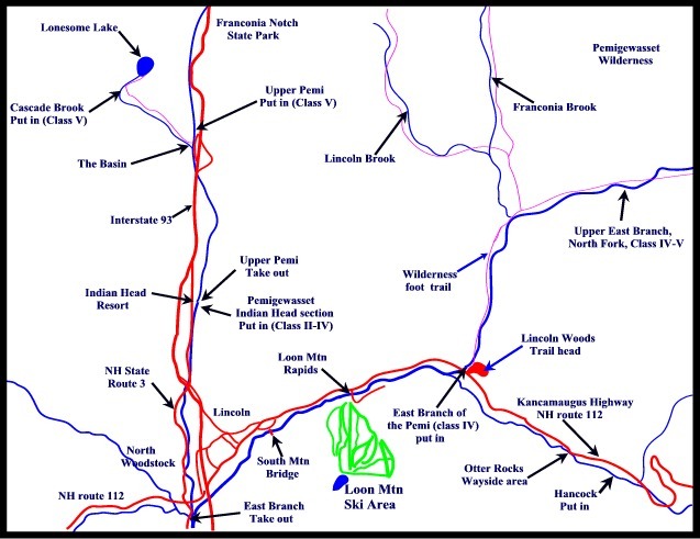
Note: Any run on this river will also include the first 3 miles of the East Branch below Franconia Falls. So the actual length of the run would be 13.5 miles.
Source: Greg and Sue Hanlon's Steep Creeks of New England, which has more info on this run. Text used with permission.
Directions (this is a very long shuttle):
For the Zealand Pond put-in: From I-93 N, take Exit 35 to Rte. 3 N; continue to Rt. 302 at Twin Mountain. Head right on 302 East; head ~2.5 miles to the sign for Zealand Camping Area. Turn right; head up the Forest Service Road approx. 3.5 miles to a small hiker's lot at the end of the road. Hike 2.6 miles to Whitewall Brook below Zealand Falls. Put in as soon as the stream has enough water to paddle.
For the Ethan Pond put-in: From the Zealand Camping Area; follow Rt. 302 past Bretton Woods Ski Area and the Mt. Washington Hotel. Continue thru Crawford Notch to where the Appalachian Trail crosses Rt. 302. Turn right and follow a short access road to the end and park. Hike up the Appalachian Trail 2.4 miles (1400 feet in elevation) to Ethan Pond (the headwaters of the North Fork). Continue past the pond until enough streams enter the North Fork to make it paddleable.
To the takeout: follow 302 West back to Rte. 3 South. Take 3 to I-93 South through Franconia Notch to Exit 32. Follow Rt. 112 East past Loon Mountain. Cross the East Branch of the Pemigewasset and park in the Forest Service lot at the Wilderness Trail on the left.
Flow Info:
The gage linked above is on the East Branch of the Pemi and has been recorrelated to the new readings. The visual paddlers gage on this run is at the takeout bridge (Rte. 112). 1.3 on the bridge 'seems to correlate' with a minimum North Fork level.
River Features

Take Out
Access PointDistance: 10.5 mi
Trip Reports
Log in to add a reportNo trip reports yet.