Wells River
2.) Lower(Old Bridge to Lower Dam)
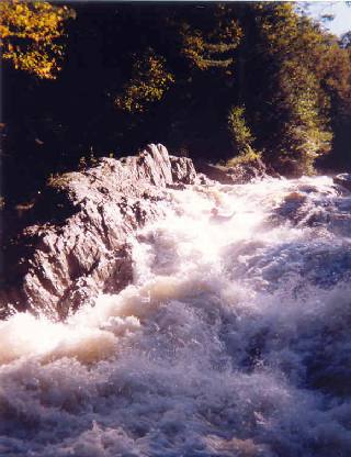
Trees still blocking left channel of last drop as of 5/22/16
There is a tree down across the river after the last rapid. It's not in the rapid itself but looks like it could be a big problem for a swimmer. Take a look if you're running it. It might need to be cut out at some point.
As of 4/18/14 the left line on the last rapid has changed with the last flooding. There are now two big stone blocks in there that weren't there before. If you're headed there definitely take a look at it. The run to the drop probably also changed a little and there's a hole in the runout that's a little meatier. The right line through the main part of the drop is the same as before though.
As of 4-13-2013 the log in the waterfall has been removed. Still worth a careful scout.
There is a log pinned vertically in the river left side (a.k.a the 'race line') of the waterfall. It's about 5-6' in dia, and as high as the falls. It is very hard to see without scrambling all the way to the bottom as the log is tucked back in a notch and very dark in color. You can see a small rooster tail coming off the top of the log from the top of the falls. Scout this very carefully. After scouting from the top with two other boaters we all missed seeing the log and I ran the drop on 4/5/13 and made solid contact with it on the way down.
On August 28th, 2011 Hurricane Irene struck New England. The resulting floods caused extensive damage throughout the region, the worst in over 100 years. More than half the rivers in Vermont and northern New Hampshire recorded their highest flow levels ever. Many roads, guardrails, power lines, bridges, trees and other debris now litter several rivers throughout the region. River beds have been scoured and changed course, many new strainers make navigation problematic at best and downright dangerous at worse. Please realize that the river description you see here may not match current situation after the floods. Use common sense and when in doubt scout especially on blind drops. Also, if you run this river in the next year or so please comment on its navigability, even if there are no problems this will be very helpful. Please report any new strainers or changes to the rapids that will impact future boating.
Thank you,
The trees mentioned have shifted in recent rains and are no longer a hazard so long as you remain river center or right. They are very much in play on river left, so don't go there!
Ran the Wells today after an early summer rain that spiked the gauge. As of today, 6/30/09, there are two downed trees forming river-wide strainers above the waterfall. Take out and portage immediately after the rapid preceding the waterfall. These trees could be potentially dangerous - if the river comes up again this summer, please be careful and scout for wood when necessary!
No articles