Firth
Margaret Lake to Beaufort Sea
| Difficulty | III-IV |
| Length | 99 mi |
| Avg Gradient | n/a |
| Reach Info Last Updated | September 3, 2004 |
With it's headwaters coming off the Brooks Range, the Firth starts in Alaska but this river
trip is on the Canadian side of the border in Ivvavik National Park. While the US continues to debate the
fate of public land on the western side of the international boundary that includes the Arctic National
Wildlife Reserve with its potential pretroleum reserves, this park protects the calving grounds of the
Porcupine caribou herd on the Canadian side. As such this trip represents a spectacular wilderness trip
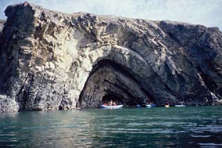
through the arctic that ends on the Arctic Ocean's Beaufort Sea. This river respresents a rare
combination of exellent whitewater, impressive scenery from the river canyons out to the coastal plain,
and a wilderness landscape with fabulous wildlife viewing.
The whitewater includes five canyon sections. You will find excellent hiking
opportunities and if you're lucky you may see musk ox.
Logistics
First you'll need to contact the Ivvavik Park to obtain a permit. They will provide you with
helpful planning materials. This trip can be somewhat expensive since there are no roads into the
watershed and you'll need to charter a flight to both the put-in and take-out. The closest town is Inuvik
at the end of the Dempster Highway and from here it's a 180 mile flight to Margaret Lake. The flight
back from Pauline Cove (Qikiqtaruk) on Herschel Island is 150 miles.
Lat/long for put-in and take-out are not accurate.
Additional Information
No trip reports yet.