Missouri
Great Falls
| Difficulty | II(V) |
| Length | 5.8 mi |
| Avg Gradient | n/a |
| Reach Info Last Updated | May 31, 2008 |
From a comment posted 2008-05-30:
The stretch of water below Morony dam offers a great day float for those interested in seeing a different part of the Missouri. There are two optional takeouts; one at Widow Coulee on Highwood Road (shorter float but longer shuttle) or at Carter Ferry. I've floated this stretch several times and love it.
Right when you put on you want to get river right to catch the nice class II run, but watch out for a couple ledges that could surprise you. It's a very short time before you get to Belt Creek, you'll see a high grass ridge jetting quickly to a huge wave at med-high flows. Even though it's only a 30-50 yd stretch, the wave there is sweet and offers great play.
After another 2 miles of swift Class II you'll come upon the ledge. This is the stopping point for a motorized craft downstream, and at med-high flows is pretty sweet.
Be sure to scout and scramble up the hill to see a Lewis and Clark marker commemorating their portage. Running the ledge is possible through the tongue. For those not interested, the line is river left.
There is also another sweet play wave right above this ledge at med-high flows, and a sneak line hugging the right cliff. Another 2 miles of II's and you're at Widow Coulee (look for an outhouse) or another 5 miles or so to Carter.
May 30, 2008
The stretch of water below Morony dam offers a great day float for
those intersted in seeing a different part of the Missouri. There are two
optional takeouts; one at Widow Coulee on the Highwood road (shorter
float but longer shuttle) or at the Carter ferry. Ive floated this stretch
several times and love it. Right when you put on you want to get river
right to catch the nice class II run, but watch out for a couple ledges
that could surprise you. Its a very short time before you get to Belt Creek
, youll see a high grass ridge jetting quickly to a huge wave at med-high
flows. Even though its only a 30-50 yd stretch, the wave there is sweet
and offers great play. After another 2 miles of swift Class II youll come
upon the ledge. This is the stopping point for a motorized craft downstream
, and at med-high flows is pretty sweet. Be sure to scout and scramble
up the hill to see a Lewis and Clark marker commerating their portage.
Running the ledge is possible through the tongue. For those not interested
the line is river left. there is also another sweet play wave right above
this ledge at med-high flows, and a sneak line hugging the right cliff.
Another 2 miles of II's and your to Widow Coulee (look for an outhouse)
or another 5 miles or so to Carter.
Aug 24, 2006
From Eric Vincent
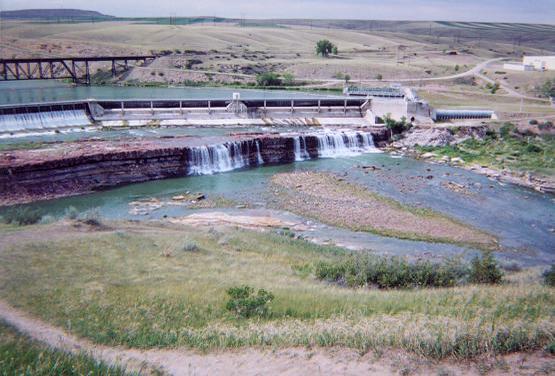
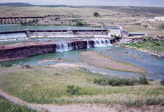
The second picture is mislabeled as 'Great Falls', it is actually Black Eagle Falls. There is a really nice wave hole and surf wave that lie just down stream (30 yards) of that pic. The dam/falls Great Falls is about 5 miles downstream. Below the last dam in the area, Morony Dam, there is a four mile stretch of class II (III) water. Great play where Belt Creek comes in, and a pretty large, sticky hole 1/2 mile downstream
Mar 24, 2004
Tailrace Rapids is pretty fun--it is just off of the far right side of the 'Great Falls Mighty MO' photo. Climb down the embankment in the left side of the photo, paddle across the river visible in the lower part of the photo, and enter through the eddy at the bottom of the tailrace. Don't trespass on the Montana Power/dam land--Great Falls boaters have done a pretty good job of maintaining a good relationship with the corporate neighbors--don't ruin it for them! I paddled it last spring at about 6,000cfs, and it was pretty fun. Locals can probably provide better beta; tailrace flows will vary with the amount of power generated. Check in with Bighorn Wilderness Outfitters downtown for good information, too.
Jul 14, 2003
I took a look at the map for this run and there are some steep creeks falling into this gorge. Also it appears as if there was a mile long rapid below the next dam near sulfur springs see http://www.topozone.com/map.asp?z=12&n=5270663&e=495950&s=25&size=l&u=1