Cold Brook
Rte. 25 to Bearcamp River
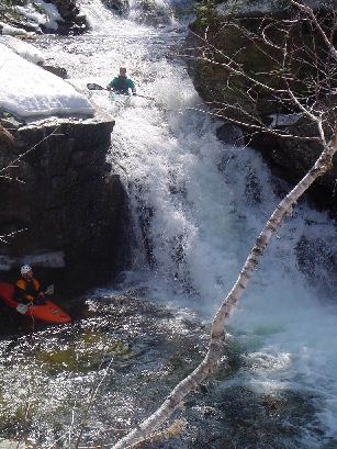
There is an unavoidable river wide log with branches downstream of the gorge section of Cold Brook (S Tamworth). The next notable drop after the gorge - the one that has a couple little holes then a zig zag move that pushes you against the right hand wall, seems like people flip there a fair amount due to the slightly overhanging rock. It's lethal, riverwide, and anyone flipped there or moving through the rapid would hit it. It's showing partway at around a 'zero' level on the abutment, it would remain in play at all except maybe the very highest levels, and at all levels to anyone flipped over or swimming.
The one end is around 6-7' diameter and it could be z-dragged off with a strong static line, or cut out.
Either way - bad spot, not visible from above.
On August 28th, 2011 Hurricane Irene struck New England. The resulting floods caused extensive damage throughout the region, the worst in over 100 years. More than half the rivers in Vermont and northern New Hampshire recorded their highest flow levels ever. Many roads, guardrails, power lines, bridges, trees and other debris now litter several rivers throughout the region. River beds have been scoured and changed course, many new strainers make navigation problematic at best and downright dangerous at worse. Please realize that the river description you see here may not match current situation after the floods. Use common sense and when in doubt scout especially on blind drops. Also, if you run this river in the next year or so please comment on its navigability, even if there are no problems this will be very helpful. Please report any new strainers or changes to the rapids that will impact future boating.
Thank you,
No articles