Potomac, North Fork of South Branch
3. Riverton to Seneca Rocks
| Difficulty | I-II(III) |
| Length | 8.9 mi |
| Avg Gradient | 30 fpm |
| Gauge | N F South Branch Potomac River at Cabins, Wv |
| Flow Rate as of 1 hour | 59 cfsbelow recommended |
| Reach Info Last Updated | February 6, 2020 |
I am going to describe this section putting in 3+ miles upstream of riverton at Judy Gap. This will give you an 11 mile run. the 7.6 mile run is too short for a day run on this swift stream.
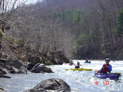
The first 7 miles of this run are characterized by cobble bar rapids, some fairly steep and technical but never exceeding class 2. Around mile 6 you will see a horizon line with a giant eddy on the right and a nice lunch spot.This 2-3 foot ledge (lunchstop ledge)is best run near the right bank.It is a straight run through the chute, but partially submerged rocks must be avoided both upstream and bordering the chute.
After the lunch spot you have a relaxing mile and a half or so until the next road bridge is encountered.Directly under this bridge is where things start to change with a faster current,higher waves, and more confused currents.In the next 3 miles you will run lots of small ledges, some in quick succession,at all angles to the river.This is a very interesting stretch of class 3 minus, with ledges running parallel,perpendicular,and catawompus.after the last of these ,it's a mile to the take-out.
The scenery on this river is nasty near the banks with old cars and chicken farms, but fantastic views of North Fork Mountain and Spruce Mountain may be viewed in the distance.
A cabins gauge reading of 5.7 should be the minimum fun level. there are many rock gardens that would require much more maneuvering and many gravel bars that would require dragging at lower levels.
HAZARDS
At the time of this writing there is no problem with wood but the river is small enough that trees are bound to be found sometimes.At high levels the low-water bridge at the take-out could pose a problem due to strong currents.The river rocks and Shale are particularly sharp, grainy, and hard on boats and your body if you swim !!
ACCESS
There are two parking lots at Judy Gap, use the downstream left one, it is much e
...