Big Panther Creek
Old Hwy 441 to dirt road off Yonah Lake Road
Feb 5, 2022
Paddled the last 3 miles of this section, putting in at what google maps refers to as the 'Panther Creek Trail East Trailhead', with the gauge for the upper hooch at 6ft and the Chattooga gauge near Clayton at 5.4ft. This river is kinda between those so I used them as a reference. Only class II stuff found within the lower 3 miles. With the water level that high there were really no rocks or anything to avoid and there were several spots with some decent waves. No riverwide strainers were found and all were easily avoidable. A fun paddle for a couple of fairly new paddlers, but if you're capable and comfortable running the stuff above the 'Panther Creek East Trailhead' then I'd say you wouldn't find the last 3 miles worthwhile.
Jun 14, 2005
The gage for Big Panther Creek is located on the 441 Old Historic Hwy culvert, upstream river right. In short, its the culvert downstream of the 'white pvc pipe' most people have been using to gage the creek.
You
Sep 18, 2004
We just ran this today (9/18/2004). I'm going to strongly disagree with Sutton's minimum and mildly disagree with Robert's: I would consider 12' on the painted gauge a minimum (this would correspond to a level about even with the above-mentioned PVC pipe). You're going to be battling alot of wood (portages and sketchy limbo maneuvers) and rhododendron in the first 2 miles, and to make that worth your time you'll want enough water on the few rapids downstream. Otherwise, it's class II - III shoals the whole way (frustratingly shallow). The slides are fun, but the big boof needed more water and the boulder gardens would definitely benefit from the reduced pinning potential afforded by more water. Have fun, and let us all know what you think.
Sep 12, 2004
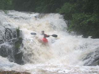
Ran BPC last week when the Chattooga the day after Chattooga crested at a little over 9 feet the night before. It was about 2 inches under the PVC pipe when we put on. It was super-fun. Here are some details. First, the shuttle is truly around-the-world. You'll spend at least 45 minutes one way. This run is truly best if you have a bunny to help. Thanks to some Athens boaters, there is now a beeline through the trees from the parking area all the way down to where the river clears out at the footbridge. It's not very wide, but it will do with some prudent ducking of rhodo. Also, the big drop under the cliff wall will hopefully be cleaned out soon -- making it the best rapid on the river -- 10 foot total double boof thing into a long around the corner slide under a cliff wall into a big hole and two good ledges immediately below. I cant wait to run this thing. Almost did even with the wood, but a mistake at the bottom would have been costly. The river opens up at the campground on the left and the footbridge. After that, you reach the first rapid, a long slide with an obvious horizon line. It's good to go, just dont go too far left and end up in the trees or too far right and end up in the undercut. Left center all the way down will be fine. After that, you'll get some creeky rapids down to the falls. You will see a narrowing of the river through a 15-foot slot with a major horizon line below. That's the falls. Start the portage before the entrance slide to be safe. Carry right. After the falls, you'll see some more great little creeky rapids until you reach the boof. 5-6 foot steep but not vertical slide into a small moving pool and right down the pipe over a perfectly clean 10-footer. Super fun. After that you'll see another horizon line. This is Automatic for the People. You should probably scout left to check out the tree situation, though the scout trail (or lack thereof) sucks. Go left of center with a little right angle down over the double boof and boogie right at the bottom to avoid the tree in the washout. Until it's gone, might consider placing a buddy down there on the tree just in case. The rapid is fine, looks a lot tougher than it actually is (and a lot easier than the portage trail). The next rapid immediately downstream is a fun slide with a tricky entrance and a major piton rock at the bottom right waiting for any stray boaters. Boof left with some good lefthand momentum to be sure to clear the ugly piton rock at the bottom right. If you hit it right, it
Jul 8, 2004
Recently talked to a fellow who had run Panther before, he said that what we tentatively called Automatic is really called Bootcamp and that the 10-footer preceded by a small slide is called Combat. He said that Bootcamp was one continuous drop at the level they ran it. I forgot to ask if the falls had been run yet.
Jul 20, 2003
Panther Creek appeared to be running this afternoon after a heavy thunderstorm. The water was rising at about 3 inches a min. So this stream can come up in a hurry even if the Chattooga is less than 4 feet.