Long Swamp Creek
Grandview Rd to Cove Rd., Near Jasper, GA((aka Cove Creek))

| Difficulty | III-IV |
| Length | 2.7 mi |
| Avg Gradient | 114 fpm |
| Reach Info Last Updated | January 13, 2009 |
This is the after work, after thunderstorm run just outside Jasper, Georgia.
There are a couple of nice runnable waterfalls. The first one can be viewed by hiking less than half a mile down the trail on river left from the put-in. Most of the run consists of bedrock rapids.
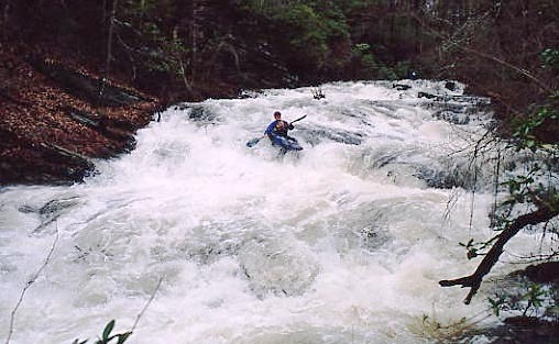
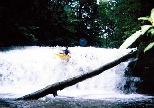
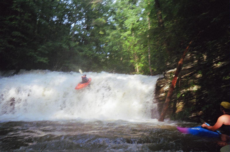
At the put-in the creek is about 15 feet wide. Look for all the rocks under the Grandview Bridge to be underwater. There are a couple of small class 3 slides, then two fairly large slides. Shortly after that is the 15 foot waterfall. Off the middle or middle left is usually preferred. The landing zone is quite deep but the lip shelf gives good boofs. Scout on the left to look for trees.
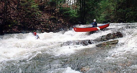
Below that are some more slides and 2 more drops of note. The first is an eight foot tall ledge with a pretty scary notch on the right. At lower flows you have to run thru the notch. Bring your elbow pads.
Next is an eight to ten foot tall ledge that can be boofed right off the middle. After that the river flattens out until the takeout. There is probably a mile of good whitewater followed by a mile and a half of flatwater to the takeout.
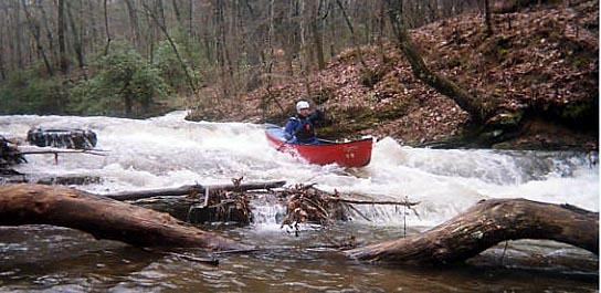
There are usually numerous logs to limbo or portage in the lower section below the rapids (which do collect wood as well). Keep a ready eye out for these. They came down during Ivan (2004) and don't look like they'll be going anywhere anytime soon.
The dam at the takeout can be run, but the landing zone is only one paddle blade deep. If you run it make sure you land the boof dead flat.
The locals still call this one Cove Creek due to the take-out being on Cove Road, but the maps all call it Long Swamp Creek.
Directions:
From Atlanta take I-575 north to Jasper. Go right (east) on Highway 53 to downtown Jasper. Cross over Main Street in Jasper, then take a left at the next light onto Burnt Mountain Road. Go about a quarter mile then take a right on Cove Road. Long Swamp Creek is the first creek you cross over
...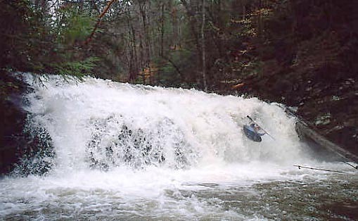
12 footer? Seems a lot like Baby Falls. Pool is very
deep (so far as boaters have probed). Most people
run middle or middle left. Middle offers a boof shelf
that creates tremendous air. Just don't land too flat
from this boof -- easy to do. Most people don't go
right, but it looks the same as any spot along the
falls. Very forgiving drop, pencil-in angles aren't
even punished. Look downstream immediately after
you land, there is sometimes small wood in the
easy 'shoals' just below the falls.
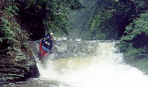
River-wide ledge in the one spot that you feel like
the river 'narrows'. Immediately after the previous
rapid. Drop consists of a river wide ledge (visible in
pic) with a sluice/slot on river right up against the
wall. Preferred line is off the middle with a boof
straight down, though many paddlers get up
against the wall. Wear your elbow pads if you're
doing that right line; it tends to choke down a bit
and bang right elbows if you don't bring them in
close. Drop doesn't develop a hole at high-water.
Nice recovery pool at bottom with big eddy on
right.
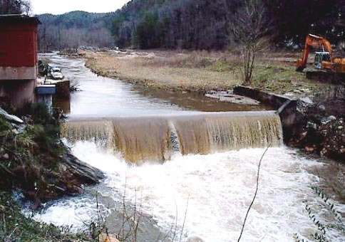
You want to see at least this much water going over the dam before setting shuttle. The dam is runnable but the landing zone is very shallow. Less than two feet deep.
Jan 7, 2009
USGS gauge 02390475 is 10 miles down stream at Reavis rd. This is a 2006 gauge so no correlation is known. It was 7' on this gauge when we ran it at 1' on the damn. It felt like a good low-medium level... ie just right.
Jul 13, 2005
I was looking on the USGS page for georgia to find a potential gauge for Long Swamp and think I may have found an indicator. USGS 2381600 is Fausett Cr. which is about 10 miles away, but is on the other side of the mountain. It spiked to over 300 on Monday when Long Swamp was pumping. Most importantly it does have a rainfall gauge which may be more valuable.
Dec 7, 2004
The gauge does not correlate like it used to...They diverted most of the water around the dam which is where the gauge is so it needs a new correlation or a new gauge below where the two channels join again
Apr 14, 2004
'The first is an eight foot tall ledge with a pretty scary notch on the right. At lower flows you have to run thru the notch. Bring your elbow pads.
Next is an eight to ten foot tall ledge that can be boofed right off the middle. After that the river flattens out until the takeout. There is probably a mile of good whitewater followed by a mile and a half of flatwater to the takeout.'
I think that is mixed up. The notch rapid is the last drop on the run. And the other one 'Exit ramp' is before this one. The scary notch one has a bad sieve/pinning spot on far right. So you want to boof the rock to the left of it (but if u dry out and slide to the right then you are in the sieve.
Jan 20, 2003
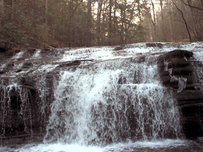
This is what the river looks like all through out, fun slides and good hole potential at high water. (The branch in the foreground is not near the water t all). The run looked clean
This was the first waterfall i saw (and only because i turned back) It is a slide that goes into a waterfall about 10-12 feet. At high it looks like a cool ski jump (or pin) on river right.
total drop was probably roughly 15-16 feet.
This is a view from directly in front, it looks like an auto boof at good water.
A little different perspective
Jan 1, 1900
Awesome run......
www.LithiumKayaking.com
Jan 1, 1900
The river was too low to be any fun, except for the falls and exit ramp....Goto http://filebox.vt.edu/users/cdgorman/index.html for more SE creeking videos