Skykomish
2 - Railroad Bridge to Big Eddy

Jan 10, 2026
We had a beautiful day on the lower Skykomish with Megan, Randy, Candice, Chris, and myself. Our group included three rafts paddled as R1s, along with two whitewater kayaks. Randy provided coaching for Candice and Chris in their rafts, making the trip both a fun outing and a productive training session.
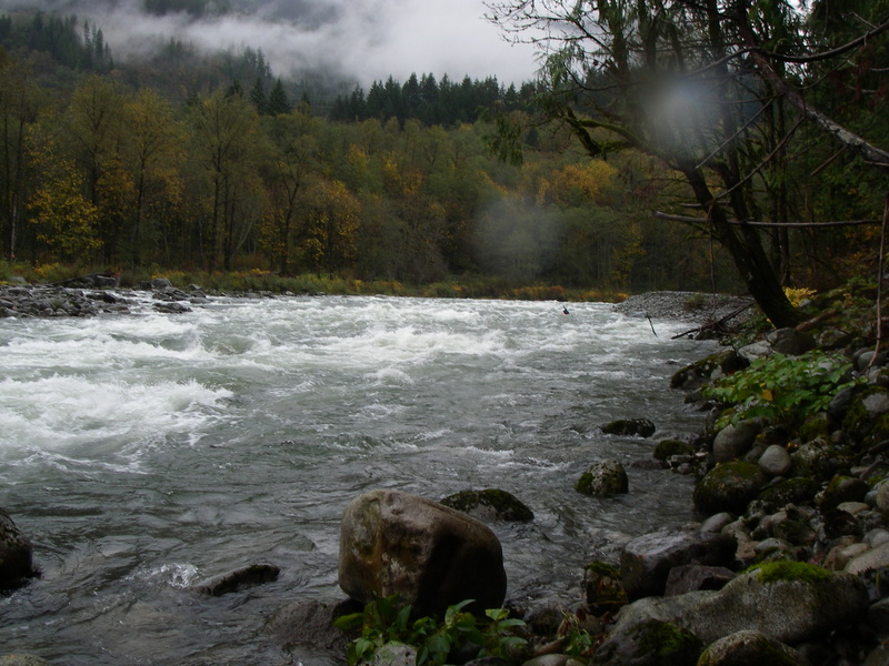
We launched at Split Rock. The put-in beach is now covered in woody debris deposited by last month’s major floods. It was not too difficult to navigate to the launch area, but we did have to climb over one medium-sized tree and step carefully through a scatter of smaller logs and branches. The most striking flood-related feature we saw from the put-in was a large log jam and wood pile perched high on the bank at the railroad bridge on river left just downstream. It was a clear visual reminder of how high the water had been. It also appears the floods have altered the actual Split Rock feature itself.
Once everyone was on the water, we headed downstream. The first rapid at the railroad bridge was very straightforward at this level. The flow felt like an ideal medium level for instruction and training, with well-formed features that are engaging without being overly pushy. Some rapids might feel a bit large for true beginners, but overall the run provided a great balance of challenge and approachability.
Fisherman’s Rapid was also straightforward. We passed a couple dozen anglers, mostly on river right, especially near the fish hatchery at the bottom of the rapid. The river corridor showed clear signs of the recent high water. Along stretches where houses line river left, the high-water mark had come very close to structures. Vegetation below that line was stripped bare of bark and foliage, leaving pale, scoured trunks and exposed roots.
As we continued downstream toward the Highway 2 bridge and the Big Eddy takeout on river left, more flood deposits were evident. Sand and sediment had accumulated at the takeout, requiring a short scramble up a sandy bank. Still, it was manageable with rafts and kayaks, and we were able to reach the vehicles without much difficulty for loading gear.
This is a short run, and we spent about an hour on the water. The weather was mostly cloudy, with the sun attempting to break through for much of the trip before finally shining briefly toward the end. Between the coaching, the ideal flow level, and the visible changes left behind by the floods, it made for a memorable day on the Skykomish.
Jul 29, 2024
For two of us (kayak and packraft) the trip started on the next run upstream at the confluence of the North and South Fork Skykokmish. We picked up another paddler (packraft) at Split Rock and continued on down to Big Eddy. We had just enough water to get through the rapids without any issues and just a few bumps although it required a bit of route finding. It might go a little lower but this was about the low end of the range.
Apr 24, 2015
Rafted this route on April 20th 2015, continuing down to the Sultan
River confluence (~another 8 miles of mellower but really pretty Class I water, described http://www.americanwhitewater.org/content/River/view/river-detail/2210/). Flow was 2950. We did the trip by packraft. Once we
were in the water (e.g., not counting the setup time), the trip took 3.5 hours for the ~10 miles,
with us paddling most of the time (we needed to make it to Sultan in time to get one of our party
to the airport). This section itself only took some 40-45 minutes to complete. =====
For the put-in, we parked at the highway pullout next to the railway bridge, just as described here. This
was a Monday, so we were the only car there. It was a sunny day, so the walk down to the river
was not muddy at all, and no problem with the super-portable packrafts. For takeout, since we wanted to raft all the way to Sultan, we left a car there at a parking lot that required the Discover Pass (though, note that we did not see a place to purchase one, if we hadn't had ours). For those who want to take out at Big Eddy, which is the official stop of this route, there is a fee box (and I think it was also Discover Pass) ===== The first 2.5 miles (the section of river described here) was good fun, lots of class II rapids that soaked us when splashing us, but did not seem to be much risk for overturning the packrafts (not sure about a kayak -- packrafts are generally much more stable).
While we didn't necessarily *want* to swim, there were no fallen trees or log jams anywhere, so
even if we had overturned, it didn't look too dangerous.===== From Big Eddy, the river mellowed. The views of
the mountains were excellent, and the river flows through a remote section that only comes towards
the road and civilization near Gold Bar and Sultan. See my trip report at http://www.americanwhitewater.org/content/River/view/river-detail/2210/ for more information on that section.
Feb 1, 2015
Stand Up Paddle Board'ed this yesterday at 3500cfs Broke my paddle on the second half for a little less control.
Check out my two runs here.
Run 1: https://www.youtube.com/watch?v=9TJV0QYja1U
Run 2 (broken Paddle): https://www.youtube.com/watch?v=DwVTOuBebhc
Oct 17, 2010
We had a fun autumn day with the kids on the Skykomish River from Split Rock down to Big Eddy.
Oct 20, 2007
Fisheman's from about halfway down.
Looking up at Fisherman's from last eddy on river left.
Jul 29, 2004
At big eddy the parking fee is $5 per day (there is a pay station), but you
are exempt from the fee if you have a yellow Washington Department of Fish and Wildlife (WDFW) vehicle use permit. sticker.
Nov 9, 2002
May 25, 2002
We launched just upstream of the railroad bridge with a couple of kayaks and a K2, including two inexperienced paddlers. Starting in the pool above the bridge provided an easy entry, but the shallow water and rocks made for some tricky maneuvering. Within the first short stretch at the bridge, one paddler flipped, leading to an early swimmer and gear recovery. Everyone was quickly back in boats and heading downstream.
As we moved into the main flow, it became clear that one of the newer paddlers was still getting comfortable with boat control. Approaching the first significant hole near the left bank, they were pulled into it, resulting in another swim. After regrouping, paddlers rotated boats to better match experience levels, and the trip continued toward Fishermen’s Rapid, the largest on the run and a Class III drop.
Above Fishermen’s, efforts were made to reach the left bank for a safer line, but the current pulled one boat into the main channel. The descent started well, but an uncontrolled line into a hole midway through the rapid led to another swim. The paddler exited the hole safely and remained eager to continue, and the group pressed on downstream.
Through the following Class II rapids, control remained a challenge, and another hole delivered a brief spin cycle. A chase and recovery followed, with all boats and paddlers brought safely to shore for a short rest. Spirits stayed high, and after a break, the group returned to the water for the final stretch.
Near the end of the run, route-finding through the last wave train required quick decisions. A challenging line was chosen, but growing confidence and newly gained skills carried the paddler through upright. The group glided into the takeout eddy together, smiling and relieved.
Overall, the trip included a couple of swims and some lively moments, but everyone made it out safely, gained experience, and finished the day in good spirits — a memorable run with teamwork, persistence, and plenty of learning on moving water. Maybe next time we’ll catch it at slightly lower flows.