Trappe
97th Street to 73rd Street (2.9 miles)
| Difficulty | I-II(III) |
| Length | 2.7 mi |
| Avg Gradient | 19 fpm |
| Gauge | Prairie River Near Merrill, Wi |
| Flow Rate as of 40 minutes | 1.99 ftbelow recommended |
| Reach Info Last Updated | September 7, 2020 |
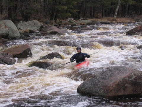
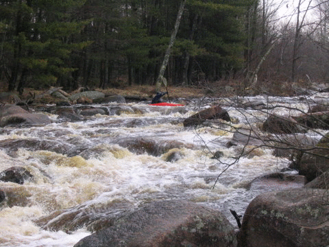
The most significant rapids is about 200 yards long and features considerably more gradient and difficulty than the rest of the run. A substantial hole midway through, followed by shallow rock (right) and a bend with a large tree/snag (left) made this a portage for most of us at the high water level.
UPDATE October 23, 2005. A group of UW Hoofers ran this stretch at probably the bare minimum (see Put-in picture). There are several minor rapids from each/any of the listed acceess points (put-ins) and the most significant rapids mentioned above. At the minimal level, this significant rapid was a steep boulder garden that resembled a pinball course, emphasis on pin. We were able to make our way through due to the low flows. Intermediate flows may make this drop ugly, if not a mandatory portage.
This run makes a great companion run for the near-by Pine River (Lincoln Co.).

For a slightly longer trip, you could put in at Hwy.G.
This adds mostly just swift-flowing water, with relatively little actual rapids.
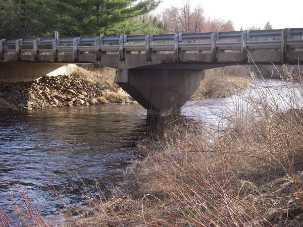
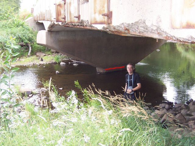
We used to list this as the put-in. However, we have reports that 'No Trespassing' signs have peen posted. Since there are other reasonable access points, we recommend avoiding potential hassle of using this location. That said, there is mention of a gauge painted at this bridge, so you may wish to stop to take note of the level (since the gauge we are using is only a reference, on a different river, which may or may not correlate to levels/flows here).
Having listed the above options (with their pros and cons), this is our recommended/standard put-in.
Drainage area at CTH.G is about 41.7 square miles (as calculated by USGS StreamStats 4.0 Beta software).
At CTH.J it has increased to 48.7 square miles.
At 97th Street (our recommended put-in) it is 49.3 square miles.
At our take-out it is 58.6 sq.mi. (an increase of 20% from our listed put-in).
Our reference gauge (Prairie at Merrill) has drainage of 184 square miles, so ...
flow on this run *could* be 0.2266 times (or a bit under 1/4th) that gauge reading.

The only significant drop on this river, and it can be quite a doozy. With any reasonably boatable flow, you will probably want to scout, and many will be likely to portage! (Low-water, maybe just class II-II+, higher water class III possibly pushing very nearly class IV-.) The river drops 20' in a relatively short distance, through a fairly complex boulder-bed and bedrock drop.
Some maps may show this area as 'Trappe River Dells County Park'. From a Marathon County brochure:
'Trappe River Dells Park – Located in the Town of Texas, this undeveloped park consists of 80 acres of woods. It is not accessible from other public lands or roads. The County has no current plans to develop the woods into a functioning park. Rather, it will remain as a passive open space.'
Jun 7, 2013
A paddled at 4.86' on the reference gauge. There is a visual gauge on the north side of the bridge support on J. It read 4.2 ft. The nice grassy put in now has a no trespassing sign, you can also put in on N. 97th st to cut the length of the run more.
The Main section was similar to that described at 5.05' in the other comment. Is best to scout unless you are familiar with the rock and hole locations or are good at read and run. This is a long and tough stretch of class III water, but so much fun.
Mar 9, 2011
Went down at 5.05' *; We did this last year at 4.21' and the main rapid was a class II. Now with the extra water the rapid turned into a succession of drops and holes and a definite class III. The main drop is the one pictured in most of the photos as the rock on river right was under water and so is the one just toward the center, which if not hit correctly will send you off course and perhaps into a swim:) I would recommend putting in at CTH J instead of G since there is a nice grassy put in on the upstream river right side and you don't miss anything except some swift current. By the way, I love catching this river. So if you are planning on paddling it let me know.