| Difficulty | I-II(III) |
| Length | 1.5 mi |
| Avg Gradient | 20 fpm |
| Reach Info Last Updated | May 19, 2025 |
River Description
This is an alternate put in for a longer trip on the Little River downstream if you cannot find parking on the North Fork and it has some fun rapids along the way including what is likely the highest boof ledge in the Triangle. Parking is somewhat limited on the shoulder of Guess Rd, river right headed back towards Durham, but we got 3 cars on there for a trip recently. Once parked, walk down the steep hill to between the bridge piers to put in.
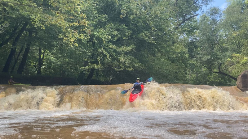
This starts out flat for the first half a mile. Once you see an island ahead, take the left channel where the rapids start. Watch for downed trees throughout, but especially around this island since it is narrow. Easy rapids continue past the island then a slightly larger rapid is reached a bit further before the river bends right. After this rapid, the river curves right into a deep area of flat past some cliffs river left and then a dock also on the left. Ahead is a 6 ft river wide ledge where the Russel Mill Dam used to be. At lower water (3 ft or less), you can exit river right just above the drop and take a look from below or portage if you don't want to run the drop. Over 3 ft on the gage, current is a bit stronger at the top of the ledge and you will need to boat scout and run the drop. We have been running the drop a bit right of center. There is a small slot that dips and drops in two stages far left, but it looks a bit sketchy. You can either eddy right in a little cove just below after the drop or continue in the boogie rapids downstream which end around the S Lowell Rd Bridge. There is an island right after the drop and it is easiest to take the right side if you are lined up at a good spot from the top. There is no room for parking at S Lowell Rd, so you will need to continue downstream for about 2.5 miles further to above the gorge at Johnson Mill Rd.
After the S Lowell Rd bridge, there are a couple more small rapids before the North and South Forks join (1.4 miles) to form the Little River prope
...River Features
Highway 157 (Guess Rd) Bridge Put-In
Access PointDistance: 0 mi
Russel Mill Ledge
RapidClass: IIIDistance: 0.98 mi
If water is low, you can get out river right to take a look. Over 3 ft, you'll probably need to boat scout. We've been running this just right of center and then taking the right channel just downstream at the island.
Little River Confluence
Access PointDistance: 1.45 mi