Pond Brook
Baker Pond to Wentworth
| Difficulty | IV-V |
| Length | 3.1 mi |
| Avg Gradient | 110 fpm |
| Gauge | Baker River Near Rumney, Nh |
| Flow Rate as of 1 hour | 0.40 ftbelow recommended |
| Reach Info Last Updated | May 29, 2006 |
Pond Brook is a very narrow steep creek. The river starts out class III then eases somewhat through a swampy area. The action picks up at about the 1 mile mark then quickly starts to build up to continuous class IV and V. It's geology is somewhat unusual for New England, it has a lot of ledgy type drops of 2' to 3' spaced closely to each other. One drop runs over a granite slide that drops approximately 30' over a 100' distance. Some of the river can be scouted from state route 25A which runs along the run but many drops are out of view from the road.
Pond Brook is located in the Upper Baker River valley about 16 miles west of Plymouth.
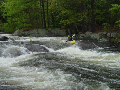
It is a relatively small river that drains Lower Baker Pond. The river itself starts at the dam at Lower Baker Pond. There is good warmup rapids for the first half mile but you must portage around a low snowmobile bridge then contend with some flat water. For this reason most paddlers chose to put in ½ mile further downstream where NH 25A comes close to the river. At this point the river is flat and running through an open marsh. Shortly after the river enters the forest class II-III rapids begin. The most significant factors in this section are tree falls and strainers. Boat scout each drop carefully to avoid problems. The action picks up about a mile and half below Lower Baker Pond. Some class III ledge drops start appearing the first of which is 'Roadside'. More small ledge drops continue until they start to pick up in intensity just after the 2 mile mark. The remaining mile of river contains the largest and most intense rapids. It is mostly away from the road but never more than a quarter mile. Starting at Z-chute there is evidence of river modifications for mills built in the 19th century. These mills are long gone but the rock work is evident all the way to the last rapid.
Posted by Dan Holzman on the MVP message board 3/30/03
Pond Brook has some outstanding ledges, very photogenic, e
...
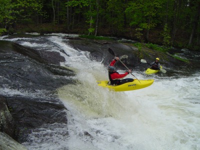
After a long series of class II and III ledge drops and rapids the river pulls in close to the route 25a on river left. Roadside rapid starts with a congested rapid that pushes a paddler towards river right then drops over a 3 foot ledge. The main flow heads directly into a couple large boulders. The left side of the ledge is rather shallow in medium water.
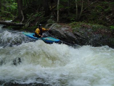
When you notice the river narrow significantly through a dark hemlock forest you are approaching the Funnel. The river narrows to 22 feet wide then drops over a 3 foot ledge. The right side below the ledge has a ski jump. Most paddlers chose to run hugging river left. Be careful when running this section since a tree fall could easily span the entire river.
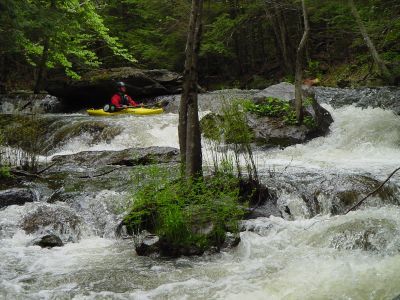
Not necessarily a tough section but it lies just above the Megaslide so a screw up here could be consequential. The river breaks up into several narrow channels amongst ledge drops. Pull out in the eddy below and scout Megaslide.
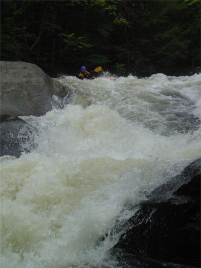
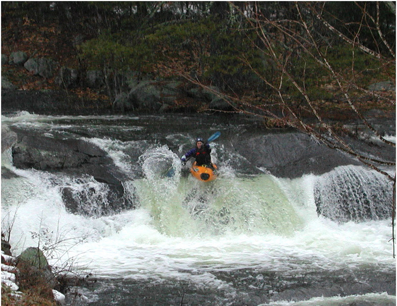
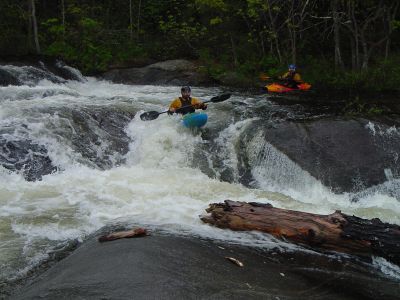
This is the toughest drop on Pond Brook. Shortly after Island the river drops over a double ledge with a somewhat sticky river wide hole. Right after the last ledge drop catch the eddy on river right just above the main part of the slide. The slide itself drops 30 ft within a distance of 100 feet. The main part of the chute forces paddlers through a large hole then directly into a rock with a vertical face upstream. This top of this rock is barely above the water surface at medium levels and forces the river sharply right through the final portion of the drop. This rock usually has a good pillow in front of it but still most paddlers tend to hit it. Good reason to have elbow pads.
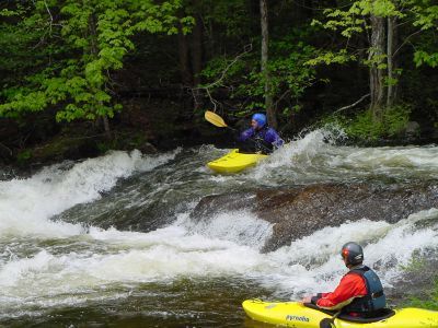
Another narrowing section of the river leads up to Z-Chute. The first ledge drops down to a large curler angled from upstream right to downstream left. Immediately after the end of the downstream left curler another curler cuts to downstream right. At the bottom there is a relatively large hole.
Located directly under the overhead power lines. At the top the river drops over a 3 to 4 foot ledge. The second drop forces the paddler to start on river left then maneuver diagonally over another 4 foot ledge towards river right.
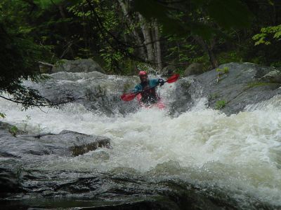
A short distance below the power lines the river drops over another series of ledges then finally runs out into a violent slide. The best approach is to run directly below a midstream boulder at the top of the first ledge then ride out the rest of the drop trying to stay upright in the violent chute between two parallel ledges on either side of the river.
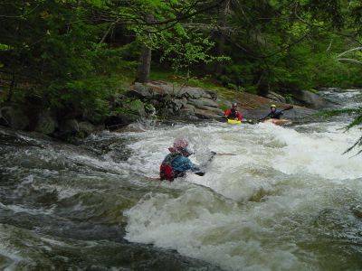
The final rapid on Pond Brook is a long and fun one. Just above the rapid the river splits around an island. The left channel is usually best. Just after the Island the river turns right and drops over a long slide best run on river right. Just after the slide there is a series of low ledges with sticky holes. A small pool lies just upstream of Backyard Boof. Line yourself up in the center of the river and push off the 8 foot vertical ledge drop. Below this there is another small ledge drop that leads to a bridge. Once past the bridge the river flattens out for the rest of its distance to the Baker River. The rapid is named after the residential backyards it flows through. The residents on river right are very friendly and take interest in our adventure just watch out for their river side flower beds if you should scout or decide to take another run on Backyard Boof.
The takeout at the bridge at Backyard rapid has limited parking but is the most convenient. If your group is small then this would be your best bet. Large groups should park their vehicles at the Wentworth ball field directly across the street from the convenience store which is just before route 25 crosses over the Baker river. The confluence of Pond Brook is actually downstream a ways. If you paddle all the way to the Baker you will have to carry back upstream some distance. Another option would be to cut across a spit of land just as Pond Brook takes a sharp right in the runout flatwater below Backyard rapid. Once at the Baker you're vehicle will be directly across the river.