Short Creek
Route 75 to Hustleville Rd.(Upper Short)
| Difficulty | II-III |
| Length | 4.5 mi |
| Avg Gradient | 25 fpm |
| Reach Info Last Updated | November 9, 2001 |
See also www.alabamawhitewater.com
.
Mar 17, 2005
Short Creek's Paddlers gage is located on the SR 75 Bridge. There are actually two SR 75 bridges crossing Short Creek. The gauge is on the upstream bridge (NE bound traffic) on river right support. Best seen from river right, upstream side of the bridge.
Levels:
ELF: 6'
Low: 9'
Medium: 2.0'
High: 3.0'
Short Creek is best correlated off of the USGS Scarham Creek gage.
When Scarham is:
170-200 cfs Short is 9'
350-400 cfs Short is about 2 feet.
As for Town Creek, its not as good an indicator as Scarham, but its a good backup gage:
When Town is:
500-600 cfs Short is 9'
1400 cfs Short is about 2 feet
I have an Excel 2000 spreadsheet that predicts the levels for Short Creek and several other rivers in the southeast. If you
Jan 1, 1900
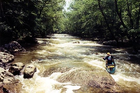
Peter Horne does a nice cross bow draw on the first class II.
Peter Horne enters Pyramid Rock. It is the first of two long class III rock garden rapids on the run.
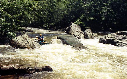
Peter Horne in the middle of Pyramid Rock. You can see the Pyramid Rock in the center of the picture.
Peter Horne running the last drop in Pyramid Rock. You can see the Pyramid Rock upstream in the center of the picture.
Peter Horne runs the entrance to The Garden. The Garden is the second and last long class III rock garden rapid on the run.
Peter Horne punches a hole in the middle of the Garden. The Garden is the second and last long class III rock garden rapid on the run.
Peter Horne runs the last section of The Garden. The Garden is the second and last long class III rock garden rapid on the run.
This is the last rapid on Upper Short Creek. From here the bridge is in sight as well as the horizon line for Short Creek Falls; a specatular 18-20 foot waterfall.