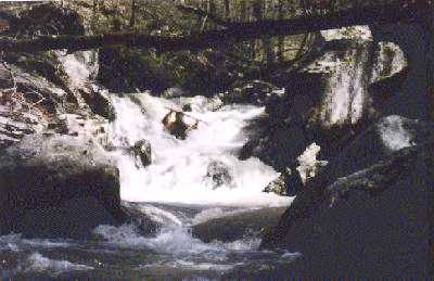
Sulphur Creek
Southern Fork to Richland Creek (1.5+4.5 miles)
| Difficulty | III-V(V+) |
| Length | 5.4 mi |
| Avg Gradient | 310 fpm |
| Gauge | Richland Creek Near Witts Spring, Ar |
| Flow Rate as of 1 hour | 0.73 ftbelow recommended |
| Reach Info Last Updated | January 26, 2009 |
Note: The combination of Steep banks and lots of dead red oak trees (thanks to the borer beetle infestation) tend to clog the creek with wood from time to time, so keep look out.
This is a very small creek, 1.5 miles long. Gradient #s are for Sulphur Creek. Continuous drops with lots of pin potential, tight slots, waterfalls, undercuts. Must run the last 4.5 miles of Lower Richland Creek, or hike back up the mountain.
More info and photos at:
