Mad River
2. Gorge(Secret Gorge)
| Difficulty | III |
| Length | 1 mi |
| Avg Gradient | 73 fpm |
| Gauge | Baker River Near Rumney, Nh |
| Flow Rate as of 1 hour | 36 cfsbelow recommended |
| Reach Info Last Updated | May 17, 2026 |
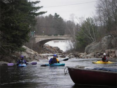
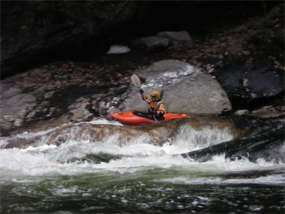
This is a nice but short pool and drop river. There are many 2 and 3 foot ledge drops amongst large granite boulders through a steep sided gorge. At low levels it can be a little scratchy at the begining and the end. There is not much playing to be had on this river section but it is a good place to learn skills for steep creaking. If the dam is spilling water put in at the first location by the dam. Walk down a steep embankment on river left downstream from the bridge. This will give you access to two warm up rapids (Upper and Lower White Pine rapid), with some surfing waves to play in. If the water is marginal or being bypassed by the hydro station it will be necessary to put in 1/4 mile further downstream.
Put in elevation........633'Take out elevation......560'Total drop..............73'Average drop/mile.......73'Distance................1.0 mileRiver width average.....50'River geology...........granite ledge, Large boulders, steep sided gorgeRiver water quality.....Good to excellent, clarity excellent.Scenery.................An isolated steep gorge next to NH route 49 and Campton village, but all are out of sight once you enter the gorge.Wildlife................Occasional Moose, deer, hawks.Interstate 93 north to exit 28.
Take a right at exit on NH 49 east approximately 1.5 miles.
Take a right (south) on NH 175 at the light.
Just after the bridge take a left and park close to the dam.
If the water is too low in this section, continue 1/4 mile to a small pull off where the river is close to the road on the right.
Head back to NH 49.
Take a left (west) at the light back towards Interstate 93
1 mile take a left at the Handyman True Value Hardeware store.
50 yards take a left and park behind the Embroidery factory building just before you e
...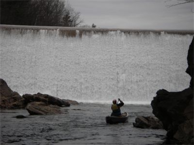
Put in at the Campton Dam at the street light a the intersection of NH rte 49 and NH rte 175. The best spot to carry down is river left just downstream of the dam and rte 175 bridge. Note that during low water much of the water is diverted form the dam through a penstock under rte 175 and re-enters the river at a micro hydro station about 500 ft downstream of the dam. If clear laminer flow continues 1/3 of the way, or greater, down the face of the dam then there should be enough water for the first couple rapids (i.e. upper and Lower Big Pine). Anything less will be a scratchy run at best.
Put in at the Campton Dam at the street light a the intersection of NH rte 49 and NH rte 175. The best spot to carry down is river left just downstream of the dam and rte 175 bridge. When water is pouring over the spillway face of the dam there is enough water for the full run.
Put in at the Campton Dam at the street light a the intersection of NH rte 49 and NH rte 175. The best spot to carry down is river left just downstream of the dam and rte 175 bridge. When water is pouring over the spillway face of the dam there is enough water for the full run.
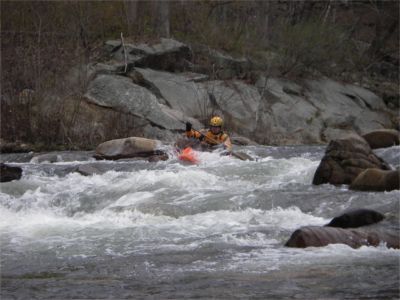
Upper and Lower Big Pine rapids are straight forward easy drops. At the lower levels, such as when the water is diverted around these rapids, they can be boney. Rapid is named for a large tall white pine tree on river left.
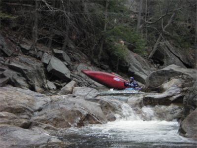
As soon as you turn right away from NH rte 175 the Mad enters the gorge section. You will immediately start encountering several ledge drops spaced only a dozen or so yards apart. One of the major ones is a couple drops downstream of an old metal discharge culvert at a cliff overhang on river left. The drop is somewhat blinded by large boulders but the river right side has a clear path. Drop is named for the Mad River Tavern which is on river right (out of sight) on top of the gorge on NH rte 49.
Nice 3 foot ledge drop great for learning boofing manuevers. Left side is more vertical and has a fairly mean hole in it at higher levels. Feature is named after Sunset Hill on river right above the gorge.

As the river slows down to a few ripples look for an easy exit over the loose gravel and boulders on the river right bank. The takeout from the road is located behind A&H Aoutomotive. From exit 28 turn right on the road between A&H and the Handyman Hardware store. Just past the harware store take a left at the Embroidery factory and park in the roadside clearings by the factory. You should take a walk into the woods to the river to try and get visual marker so you can recognize the takeout from riverside.
May 17, 2026
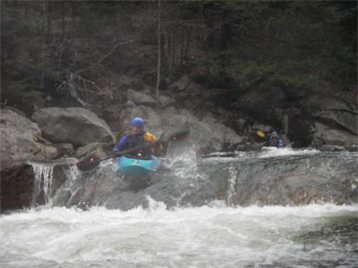
A large amount of water was falling over the spillway with a deafening roar when up close to the dam. Spicy action with a half-dozen fluid drops with Class 3+ character. Boat scouting is accessible for every drop and pools allow for easy self-rescue when needed. It is a good idea to mark the take-out with a flag if you are unfamiliar with this section.
Dec 18, 2023
This is my home run and I have kayaked it before at 500cfs (it is runnable at that level, a bit bumpy but nice if you are new to drops). I have made plans to fully photograph each river section to create a better page for this run as I get to know it better, as the photos on this page are old.
Some other general things to know about this run:
-Large logs fall over the dam often, and may get lodged within the narrow gorge sections making them impassable. It may be hard to portage around blocked sections due to the steep walls of the gorge in some areas.
-The take out is currently marked by a small pink tape off of a small tree. As you leave the run, look for the short cut through the woods to the road. It not, you may feel like you are walking in to someones backyard before turning to the road (because you kind of are). There is also a small pet (?) grave in front of the take out.
-There is now a small walking suspension bridge over the first rapid. I'm not sure if it is open to public use, but has been marked with 'do not enter' signs at various times. It lead to a small building, maybe its an airbnb.
-After the first set of rapids, some of the rocks on the left have 'do not trespass' signs on the rocks (they may be washed away now). Please be respectful of the residence who live alongside the river, as this is a recent development.
However, due to severe weather in the area (12/18/23), the gorge is currently running at 9000 cfs and is suspected to countinue rising. There will be significant changes to the river flow, bank errosion, and potentially features. Be catious if you chose to run this river after this event, as the current descriptions may not accuratly reflect the river state. The banks on both the put in and take out will most likey have suffered some significant erosion as well.
Hopefully this summer I will find time to provide new photographs for this run as it is super fun, and hopefully it will remain runable after this extreme rain event.