Ammonoosuc
5. Pierce bridge to NH 116
| Difficulty | II-IV |
| Length | 7.4 mi |
| Avg Gradient | 40 fpm |
| Gauge | Ammonoosuc River at Bethlehem Junction, Nh |
| Flow Rate as of 1 hour | 1.42 ftbelow recommended |
| Reach Info Last Updated | April 6, 2025 |
Pierce Bridge Put-In: Access the large gravel lot on River Rd just behind the large bridge on Rt 302. There is a 300 ft walking trail down to the river. This is the take-out for the upper section and a great spot for lunch if doing the Class II upper section in the morning and the Class III lower section in the afternoon. This section contains LONG lengths of flatwater and quickwater -- nearly half the run, so plan to engage in a good shoulder work out! There is also a significant river-left portage around Powerhouse Dam. At 3 ft and below, all rapids are Class III and under and the river is slow-going on the flats. At 3.5 ft, the river is more lively and the big rapids increase in difficulty. At 4 ft and above,the major rapids approach Class IV character.
Maplewood Put-in: At the end of River Rd there is a bridge over the river with a small parking area (only 2 cars). This is a good take-out for any paddler who wants to push through Powerhouse Rapid, but avoid Alder Brook and Railroad Rapids at the end of the run.
Powerline Put-in: To bypass the LONG flats after Powerhouse Rapid, put in at the powerlines on NH Rt 116 (44.323311, -71.678313). This gives you a 2-mile short run and puts you in about a half-mile above the beginning of Alder Brook Rapid.
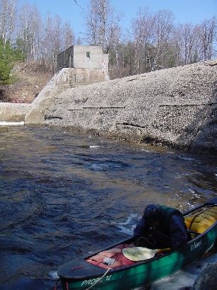
Put in elevation........1167'Take out elevation......875'Total drop..............292'1st mile................32'2nd mile................7'3rd mile................79'4th mile................46'5th mile................26'6th mile................33'7th mile................46'7.3 mile................23' (77 average)Average drop/mile.......40'Distance................7.3 milesRiver width average.....70'River geology...........Small to medium granite bouldersRiver water quality.....good to excellent, clarity good.Scenery.................Nice Mountain scenery, river parallels road most of the wayWildlife................Deer, hawks, mooseA riverwide concrete dam with a dangerous wood-clogged sluice on the right side. The portage on river left is easiest, be sure not to approach the spillway if water is breaching over the concrete (5 ft and above). Portage down a wide trail to less steep access to the river and put in just BELOW the strong recirculating eddy adjacent to the dam.
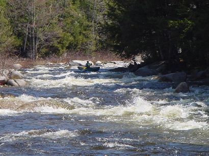
Your group may drop boats and continue to walk the trail to scout the long rapid. Once settled in an eddy at the top, wend your way across to river-right and catch a wide eddy. This offers a better view of the rest of the rapid. Again, work your way to another eddy on river right, then an eddy on river left crossing the strong currents and avoiding boulders and holes. The last section requires a zig-zag maneuver through a shallow pour-over that will bobble your boat and push you into a boulder in river center just above a large pool, great for recovery if anyone swims above. The river takes a sharp right turn and there are three more small drops with several large eddies in between.
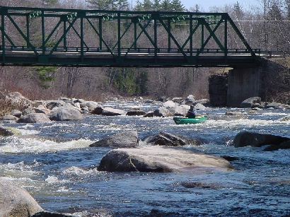
An easy rapid the starts just above the Maplewood bridge. At the tail end of the rapid is a chute formed by a large rock on river right. The main flow at low to medium water levels pushes over a pourover in the middle of the chute. The pourover is easily avoided by catching the eddy behind the rock on river right. From here a jet ferry will carry you above the pourover into an eddy on river left. This eddy affords great access to a series of nice surfable standing waves just below the pourover.
After a long section of quickwater and class I the river approaches Alderbrook rapids about a half-mile below the powerline crossing. Portaging is easiest from river right, which is also the roadside. The rapid is series of large boulders and occasional eddies that define a consistent zig-zag through-line driving mainly river-center. There are some powerful pour-overs that will set your boat on a trajectory into the next boulder, so work is required to maintain the zig-zag pattern to the end of the rapid.
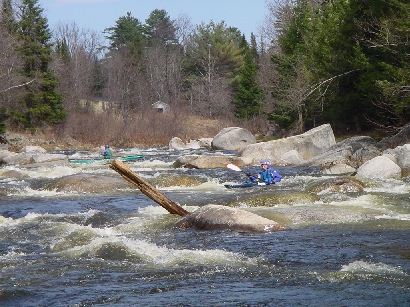
Just before the takeout is the last good rapid on the Ammo. The best route is generally on river right eddy hopping between boulders to avoid some rather large holes.
No trip reports yet.