| Difficulty | II-IV |
| Length | 3.7 mi |
| Avg Gradient | 76 fpm |
| Gauge | Pemigewasset River at Woodstock, Nh |
| Flow Rate as of 1 hour | 2.36 ftbelow recommended |
| Reach Info Last Updated | May 2, 2018 |
River Description
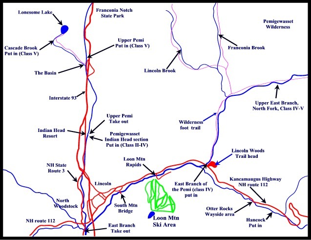
This section of the Pemi is not run often. Its season is relatively short, usually April into early May. When it is running boaters often head to the East Branch, Swift, Ammo and other area rivers. This section of the Pemi lies just below the class V upper Pemi. It runs parallel to a tourist corridor with motels, restaurants and other businesses just out of site from the river. There are a couple class IV boulder drops in the first mile of the run, there is a class IV ledge drop about 1/2 mile upstream from the takeout behind Truant's Tavern on Main street in Woodstock. Most of the rest of the river is class II with several harder sections above and below the Interstate overpass. There is one short portage over a dam 1/4 mile below the bridge at Clarks Trading Post.
Technical Info
Put in elevation........1000'Take out elevation......679'Total drop..............321'Average drop/mile.......76'Distance................4.25 milesRiver width average.....30'River geology...........Medium granite boulders, some ledgeRiver water quality.....Excellent, crystal clear,Scenery.................Parallels tourist corridor, some businesses                        from river.  Road ocassionally visibleWildlife................Occasional deer, moose, trained black bears, tourist

Flow Info:

The gage lies below the confluence of the East Branch and Lost rivers. Be aware that heavier runoff from one of these feeder streams due to a localized rain event could skew the readings.
River Features
Take Out
Access PointDistance: 4.25 mi